MyTopo
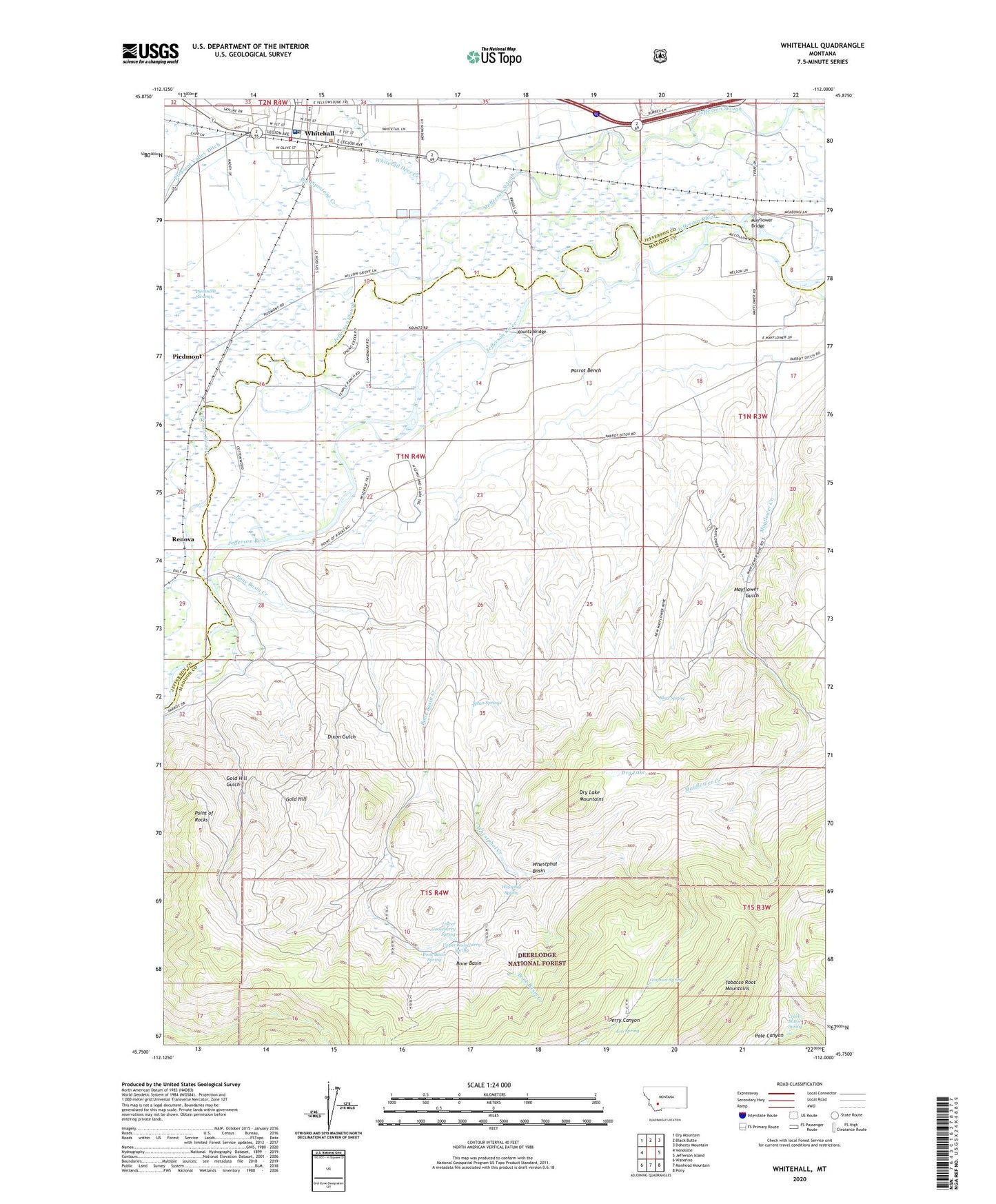
Whitehall Montana US Topo Map
Couldn't load pickup availability
Also explore the Whitehall Forest Service Topo of this same quad for updated USFS data
2024 topographic map quadrangle Whitehall in the state of Montana. Scale: 1:24000. Based on the newly updated USGS 7.5' US Topo map series, this map is in the following counties: Madison, Jefferson. The map contains contour data, water features, and other items you are used to seeing on USGS maps, but also has updated roads and other features. This is the next generation of topographic maps. Printed on high-quality waterproof paper with UV fade-resistant inks.
Quads adjacent to this one:
West: Vendome
Northwest: Dry Mountain
North: Black Butte
Northeast: Doherty Mountain
East: Jefferson Island
Southeast: Pony
South: Manhead Mountain
Southwest: Waterloo
This map covers the same area as the classic USGS quad with code o45112g1.
Contains the following named places: 01N03W17ABDA01 Well, 01N04W03BADD01 Well, 01N04W04ABBA01 Well, 01N04W04ACCD01 Well, 01N04W04ADDA01 Well, 02N04W28CDCB01 Well, Assembly of God Church, Big Pipestone Creek, Bone Basin, Bone Basin Creek, Bone Basin Spring, Chicago Milwaukee and Saint Paul Crossing, Creek Bottom Spring, Dixon Gulch, Dry Lake, Dry Lake Mountains, Era Spring, Fish Creek, Free Christian Church, Gold Hill, Gold Hill Gulch, Guymon Spring, Jefferson Valley Baptist Church, Jefferson Valley Museum, John Gregory Memorial Library, Kountz, Kountz Bridge, Kountz Bridge Fishing Access Site, La Casa Trailer Park, Lower Gooseberry Spring, Mayflower, Mayflower Bridge, Mayflower Bridge Fishing Access Site, Mayflower Creek, Mayflower Gulch, Mayflower Mine, Mud Spring, NE SW Section 9 Mine, NW SE Section 31 Mine, NW SW Section 34 Mine, Parrot Bench, Parrot Castle Fishing Access Site, Perry Canyon Mine, Point of Rocks, Renova, Rice Motel and Trailer Court, Saint Teresa Catholic Church, SE NW Section 4 Mine, SE SW Section 3 Mine, SE SW Section 5 Mine, Splan Springs, SW SE Section 30 Mine, SW SW Section 29 Mine, The Church of Jesus Christ of Latter Day Saints, Town of Whitehall, Trinity Methodist Church, Upper Gooseberry Spring, West Mayflower Mine, Westphal Spring, Whestphal Basin, Whestphal Creek, Whitehall, Whitehall Ambulance, Whitehall Creek RV Park, Whitehall Elementary, Whitehall Fire Hall, Whitehall Medical Clinic, Whitehall Museum, Whitehall Police Department, Whitehall Post Office, Whitehall Volunteer Fire Department, Whitetail Deer Creek, Zion Lutheran Church