MyTopo
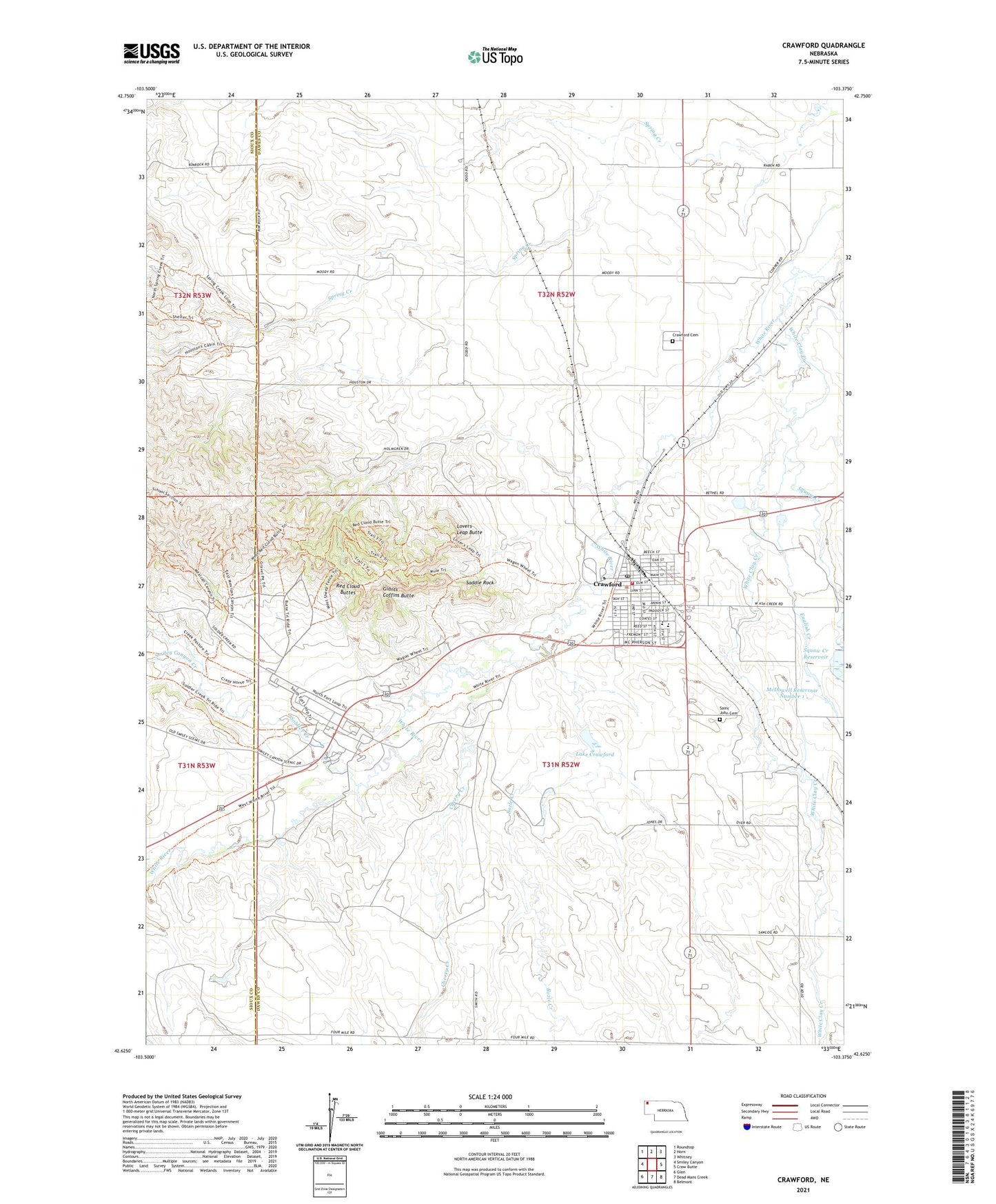
Crawford Nebraska US Topo Map
Couldn't load pickup availability
Also explore the Crawford Forest Service Topo of this same quad for updated USFS data
2023 topographic map quadrangle Crawford in the state of Nebraska. Scale: 1:24000. Based on the newly updated USGS 7.5' US Topo map series, this map is in the following counties: Dawes, Sioux. The map contains contour data, water features, and other items you are used to seeing on USGS maps, but also has updated roads and other features. This is the next generation of topographic maps. Printed on high-quality waterproof paper with UV fade-resistant inks.
Quads adjacent to this one:
West: Smiley Canyon
Northwest: Roundtop
North: Horn
Northeast: Whitney
East: Crow Butte
Southeast: Belmont
South: Dead Mans Creek
Southwest: Glen
This map covers the same area as the classic USGS quad with code o42103f4.
Contains the following named places: Adobe Officers Quarters Historical Marker, Barracks Row Historical Marker, Bozle Creek, Brick Barracks Historical Marker, Buffalo Soldiers at Fort Robinson Historical Marker, Cherry Creek, Christ Community Church, City of Crawford, Clinic - Legend Buttes Health Services of Crawford, Congregational Church, Crawford, Crawford Cemetery, Crawford City Park, Crawford Elementary School, Crawford High School, Crawford Historical Marker, Crawford National Fish Hatchery, Crawford Post Office, Crawford Public Library, Crawford School Bell Historical Marker, Crawford Volunteer Fire Department, Dawes County Sheriff's Office, English Creek, Finnegan Park, Flagstaff Historical Marker, Fort Robinson, Fort Robinson and the Railroad Historical Marker, Fort Robinson Camping Area, Fort Robinson Historical Marker, Fort Robinson Museum, Fort Robinson Post Office, Fort Robinson State Park, Fort Robinson State Park Museum, German POW Camp Historical Marker, Giants Coffins Butte, Hospital - Legend Buttes Health Services of Crawford, K-9 Training Area Historical Marker, Lake Crawford, Legend Buttes Golf Course, Lovers Leap Butte, McDowell Dam Number 1, McDowell Reservoir Number 1, Officers Row Historical Marker, Ponderosa Villa, Post Headquarters Historical Marker, Prehistoric Prairies Discovery Center, Red Cloud Agency Historical Marker, Red Cloud Agency Historical Site, Red Cloud Buttes, Saddle Rock, Saint John Cemetery, Saint John the Baptist Church, Saw Log Creek, Smiley Canyon Creek, Soldier Creek, Squaw Creek, Squaw Creek Reservoir, The Cheyenne Outbreak Historical Marker, The Death of Baptiste Garnier Historical Marker, The Fort Robinson Cemetery Historical Marker, Trailside Museum, United Methodist Church, White Clay Creek, White River Trail