MyTopo
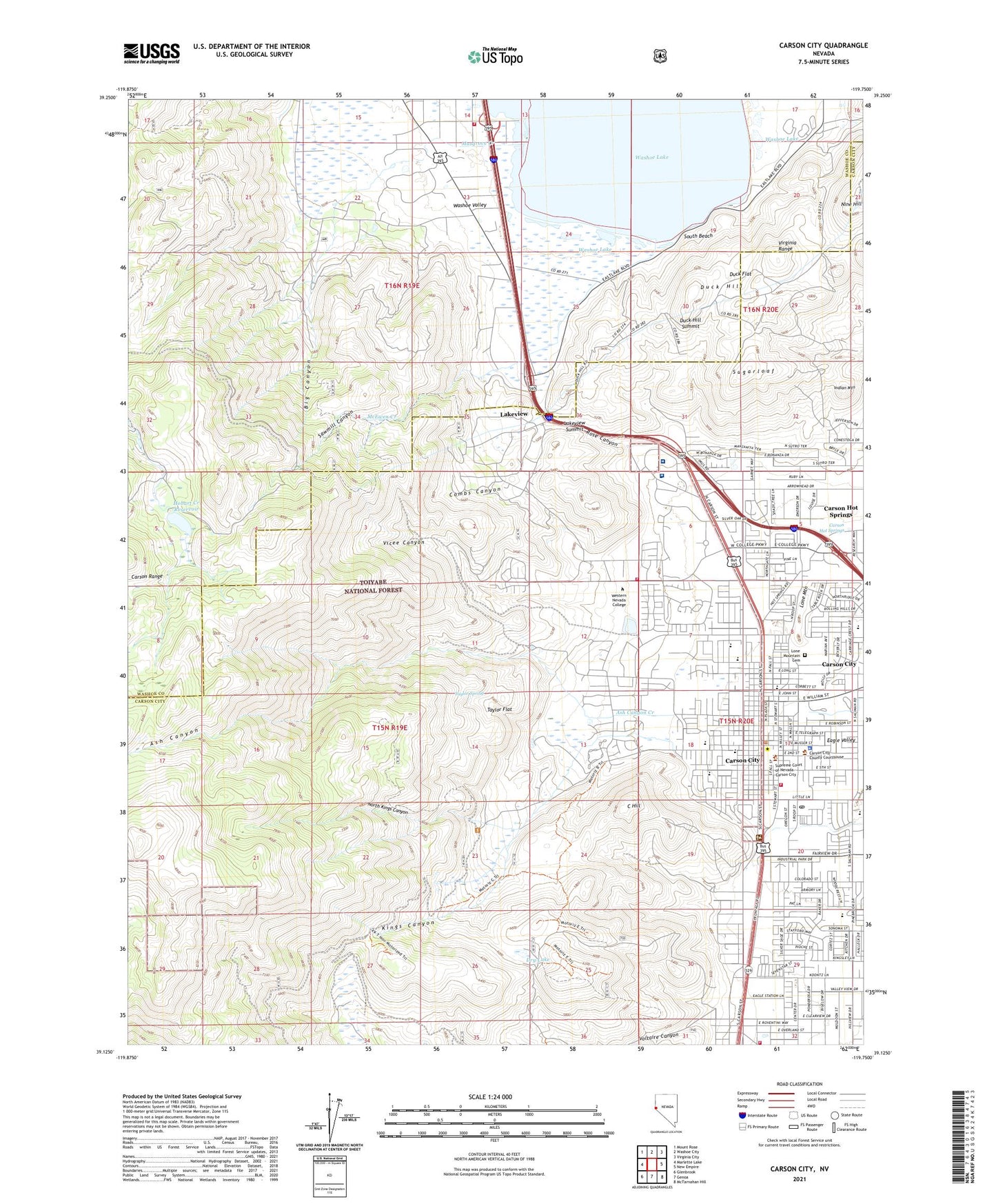
Carson City Nevada US Topo Map
Couldn't load pickup availability
Also explore the Carson City Forest Service Topo of this same quad for updated USFS data
2021 topographic map quadrangle Carson City in the state of Nevada. Scale: 1:24000. Based on the newly updated USGS 7.5' US Topo map series, this map is in the following counties: Carson City (city), Washoe. The map contains contour data, water features, and other items you are used to seeing on USGS maps, but also has updated roads and other features. This is the next generation of topographic maps. Printed on high-quality waterproof paper with UV fade-resistant inks.
Quads adjacent to this one:
West: Marlette Lake
Northwest: Mount Rose
North: Washoe City
Northeast: Virginia City
East: New Empire
Southeast: McTarnahan Hill
South: Genoa
Southwest: Glenbrook
This map covers the same area as the classic USGS quad with code o39119b7.
Contains the following named places: Al Seeliger Elementary School, Ash Canyon, Ash Canyon Creek, Ashs Sawmill, Athens Mine, Bellvue Day Use Area, Bernadette Murphy Juvenile Detention, Bethlehem Lutheran School, Big Canyon, Bordewich Bray Elementary School, C Hill, Camp Nye, Carson Black Lead Mine, Carson City, Carson City Fire Department Station 51, Carson City Fire Department Station 53, Carson City Post Office, Carson City Seventh Day Adventist School, Carson City Sheriff's Office, Carson City Station, Carson Colony, Carson Convalescent Center, Carson Hot Springs, Carson Mall, Carson Middle School, Carson Mine, Carson Mining District, Carson Ranger Station, Carson Recreation Area, Carson Rest Area, Carson Shopping Center, Carson Tahoe Regional Medical Center, Carson-Tahoe Hospital Heliport, Combs Canyon, Comstock Extension Mine, Deadmans Canyon Dam, Deadmans Canyon Reservoir, Dry Lake, Duck Flat, Duck Hill, Duck Hill Summit, Eagle Station, Eagle Station Shopping Center, Eagle Valley, Eagle Valley Ranch Childrens Foundation, Educare Academy, Evergreen Carson City Hospital, Evergreen Mountain View Health Center, Fremont Elementary School, Fritsch Elementary School, Frontier Plaza, Golden Eagle Mine, Governors Field, Gregorys Mill, Hobart Creek, Hobart Creek Dam, Hobart Creek Reservoir, Indian Mountain, Kings Canyon, Kings Canyon Creek, Lake View Post Office, Lakeview, Lakeview Summit, Landmark Letter, Lewers Creek, Lighting W Ranch, List Ranch, Lone Mountain, Lone Mountain Cemetery, Lucky Strike Mine, Mark Twain Elementary School, Market Spot Shopping Center, Martha Gleason Elementary School, McEwen Creek, Mill Creek Settlement, Mill Station, Mills Park, Montreal Mine, Musgrove Creek, Nevada Division of Forestry Western Area Station, Nevada Governor Mansion, Nevada Highway Patrol Headquarters, Nevada Highway Patrol Northern Command Carson City, Nevada State Capitol, Nine Hill, North Kings Canyon, Ohio Mine, Panama Canal Mine, Pioneer High School, Premier Mine, Red House, Rose Canyon, Ross Gold Park, Saint Teresa of Avila Catholic School, San Antonio Ranch, Sawmill Canyon, Sierra Fire Protection District Washoe Valley Volunteer Fire Department, Sierra Surgery Hospital, Silver City Mall, Silver State High School, Snow Valley, South Beach, Sugarloaf, Sunny Acres Childrens Home, Swifts Station, Taylor Flat, Taylor Spring, The Mallard Center, The Tanks, Vicee Canyon, Voltaire Canyon, Voltaire Mine, Voltaire Mining District, Washoe Lake State Park, Washoe Pines Ranch, Washoe Tribal Police Department, Western Nevada College, Woods Ranch, ZIP Code: 89703