MyTopo
Marlborough New Hampshire US Topo Map
Couldn't load pickup availability
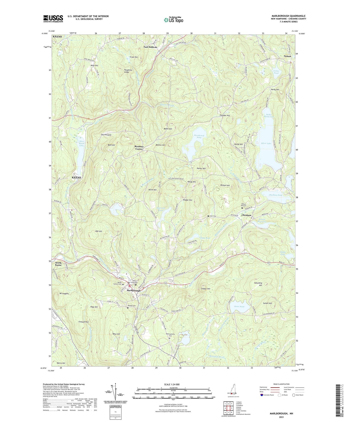
2024 topographic map quadrangle Marlborough in the state of New Hampshire. Scale: 1:24000. Based on the newly updated USGS 7.5' US Topo map series, this map is in the following counties: Cheshire. The map contains contour data, water features, and other items you are used to seeing on USGS maps, but also has updated roads and other features. This is the next generation of topographic maps. Printed on high-quality waterproof paper with UV fade-resistant inks.
Quads adjacent to this one:
West: Keene
Northwest: Gilsum
North: Marlow
Northeast: Stoddard
East: Dublin
Southeast: Monadnock Mountain
South: Troy
Southwest: West Swanzey
Contains the following named places: Babbidge Reservoir, Babbidge Reservoir Dam, Bald Hill, Banks Hill, Bassett Hill, Center Pond, Center Pond Dam, Chesham, Chesham Pond, Chesham Pond Dam, Chesham Village District, Childrens Camp, Clapp Pond, Cooper Hill, Derby Hill, East Cemetery, East Sullivan, Echo Lake Dam, Federated Church of Marlborough, Ferry Brook, Forbush Hill, Frost Hill, Hardy Hill, Horse Hill, Houghton Ledge, Howe Reservoir, Howe Reservoir Dam, Hubbard Brook, Kidder Hill, Leighton State Forest, Marcy Hill, Marienfeld Camp, Marl - Harris First Aid and Emergency Squad, Marlborough, Marlborough Census Designated Place, Marlborough Fire Department, Marlborough Post Office, Marlborough School, Marlborough Town Hall, Marlborough Town Police Department, Meetinghouse Cemetery, Meetinghouse Pond, Meetinghouse Pond Dam, Minnewawa Brook, Minnewawa Dam, Minniwawa Brook Reservoir, Mount Calvary Cemetery, Mount Huggins, Mountain Brook, Nelson, Nelson Congregational Church, Nims Hill, Oak Hill, Otter Brook, Otter Brook Dam, Otter Brook Lake, Otter Brook State Park, Page Hill, Parker Hill, Pine Grove Cemetery, Pinnacle Mountain Ski Area, Pottersville Historic District, Rhodes Cemetery, Roaring Brook, Robbins Brook, Roxbury Center, Roxbury Fire Department, Roxbury Police Department, Roxbury School, Russell Reservoir, Russell Reservoir Dam, Sacred Heart Church, Saint Francis Church, Seaver Reservoir, Silver Lake, Silver Lake Dam, Silver Lake District, South Keene, Spaulding Hill, Spectacle Pond, Stone Pond, Stone Pond Brook, Stone Pond Dam, Sucker Brook Cove, Sunset Hill, The Pinnacle, Thunder Hill, Town of Marlborough, Town of Roxbury, Wells Memorial School, West Hill, Wheeler Brook, Wight Pond, Willard Brook, Willard Hill, Willard Hill Cemetery, Woodward Pond, WTIJ-AM (Roxbury), ZIP Code: 03455