MyTopo
Carlsbad East New Mexico US Topo Map
Couldn't load pickup availability
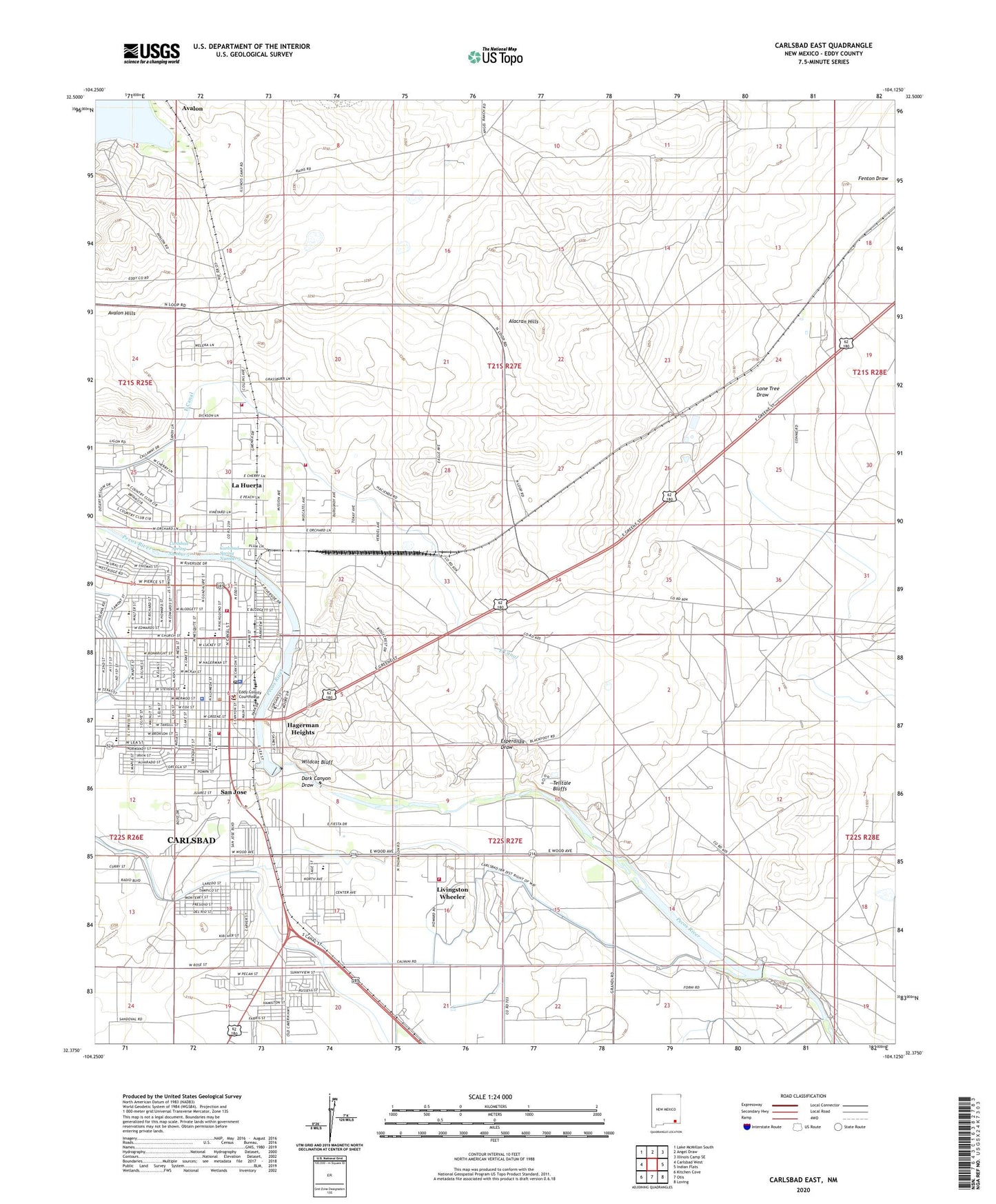
2023 topographic map quadrangle Carlsbad East in the state of New Mexico. Scale: 1:24000. Based on the newly updated USGS 7.5' US Topo map series, this map is in the following counties: Eddy. The map contains contour data, water features, and other items you are used to seeing on USGS maps, but also has updated roads and other features. This is the next generation of topographic maps. Printed on high-quality waterproof paper with UV fade-resistant inks.
Quads adjacent to this one:
West: Carlsbad West
Northwest: Lake McMillan South
North: Angel Draw
Northeast: Illinois Camp SE
East: Indian Flats
Southeast: Loving
South: Otis
Southwest: Kitchen Cove
This map covers the same area as the classic USGS quad with code o32104d2.
Contains the following named places: 10191 Water Well, 10192 Water Well, 10194 Water Well, 10196 Water Well, 10197 Water Well, 10198 Water Well, 10199 Water Well, 10200 Water Well, 10201 Water Well, 10202 Water Well, 10204 Water Well, 10205 Water Well, 10206 Water Well, 10207 Water Well, 10216 Water Well, 10224 Water Well, 10225 Water Well, 10226 Water Well, 10227 Water Well, 10228 Water Well, 10229 Water Well, 10230 Water Well, 10231 Water Well, 10232 Water Well, 10234 Water Well, 10235 Water Well, 10238 Water Well, 10410 Water Well, 10412 Water Well, Alacran Hills, Alta Vista Middle School, Alternative School Program, Avalon, Avalon Hills, Becker, Bond Ranch, Boyd Park, Calvary Assembly of God Church, CARC Farm School, Care Plus Ambulance, Carlsbad, Carlsbad Fire Department, Carlsbad Fire Department Station 3, Carlsbad Fire Department Station 5, Carlsbad High School, Carlsbad Historical Marker, Carlsbad Municipal Fine Arts Center and Museum, Carlsbad Police Department, Carlsbad Post Office, Carlsbad Public Library, Carlsbad Reclamation Project, Carlsbad Spring Number 3, Carlsbad Spring Number 5, Carlsbad Weather Station, Church of Christ, Church of the Nazarene, City of Carlsbad, Constructors Pit Incorporated Crusher, Dark Canyon Draw, Doctor E M Smith Elementary School, East Canal, Eddy and Bissell Livestock Company Headquarters Historic Site, Eddy County Courthouse Historic Site, Eddy County Sheriff's Office, Eddy Elementary School, Eddy National Bank Historic Site, Edison Kindergarten Center, Eisenhower Middle School, Esperanza Draw, Fenton Draw, Guadalupe Medical Center Library, Hagerman Heights, Hillcrest Elementary School, Hillview Baptist Church, J J Hagerman House Historic Site, Joe Stanley Smith School, KAMQ-AM (Carlsbad), KATK-AM (Carlsbad), KATK-FM (Carlsbad), KBPM-La Huerta (Los Alamos), KCCC-AM (Carlsbad), KDIR-TV (Carlsbad), La Huerta, La Huerta Census Designated Place, La Huerta Fire Department Station 1, La Huerta Volunteer Fire Department Station 2, Livingston Wheeler Census Designated Place, Lone Tree Draw, Lower Tonsill Lake, Lower Transill Dam, Lower Transill Reservoir, Monterrey Elementary School, New Mexico Salt Company, New Mexico State Police District 3 Carlsbad, New Mexico State University - Carlsbad Branch, New Mexico State University at Carlsbad Library, North Mesa Medical and Dental Group Library, Omega Christian Fellowship Church, Otis Volunteer Fire Department Station 2, P R Leyva Junior High School, Pate Elementary School, Phoenix Adobe, Popes Wells Site, Potters House Full Gospel, Primera Iglesia Bautista, Puckett Elementary School, Ranch Acres Baptist Church, Riverside Elementary School, Rose Pit, Saint Edwards School, Saint Francis Family Medical Center, Saint Peters Evangelical Lutheran Church, San Jose, San Jose Church, Six Mile Dam, Spanish Assembly of God Church, Sunset Elementary School, Tansill Dam, Telltale Bluffs, Townsite Salt, Victory Christian Academy, Walter Craft AWARE Program School, Westinghouse Electric Corporation WIPP Library, Wildcat Bluff, Willow lake