MyTopo
Little Falls New York US Topo Map
Couldn't load pickup availability
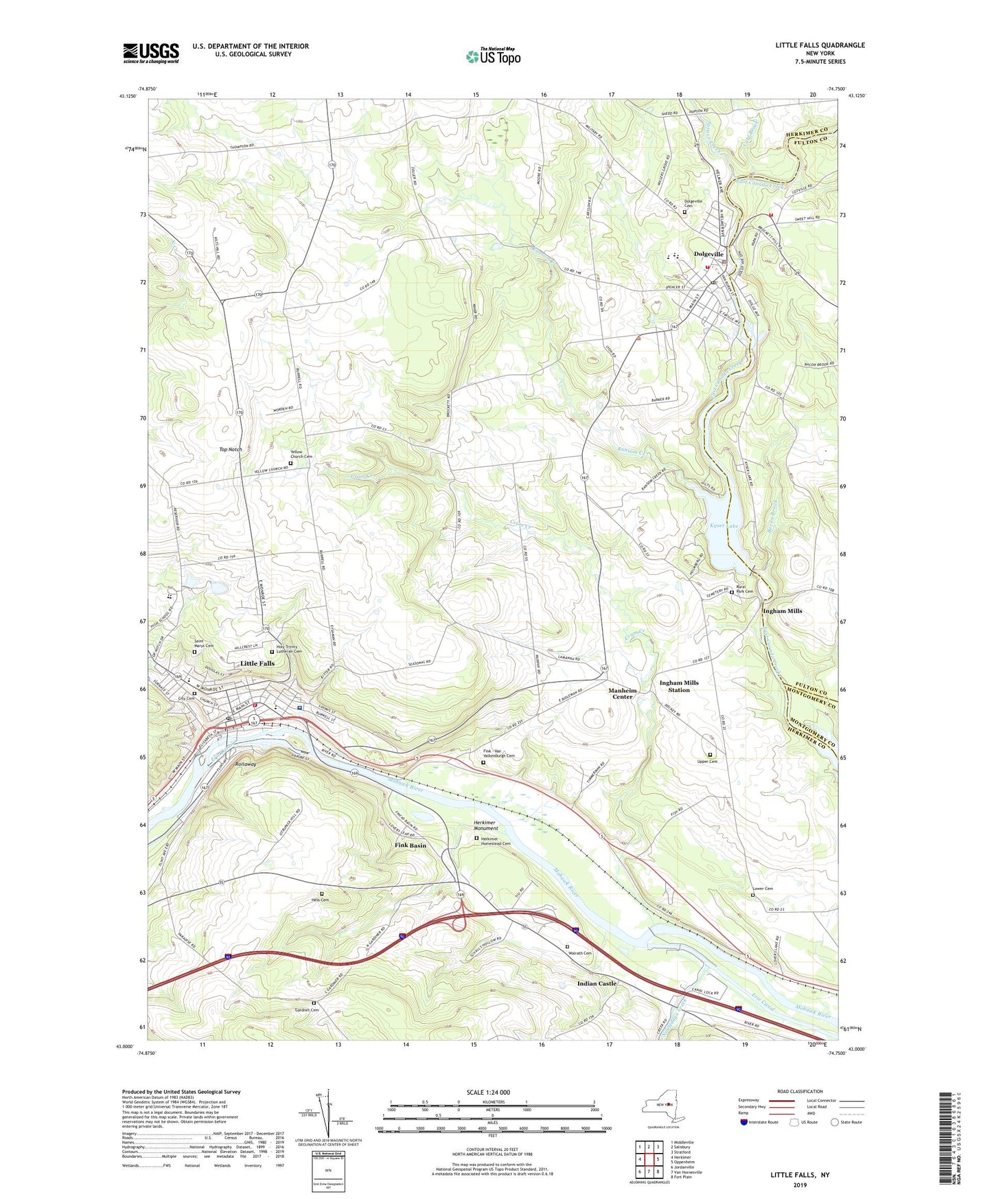
2023 topographic map quadrangle Little Falls in the state of New York. Scale: 1:24000. Based on the newly updated USGS 7.5' US Topo map series, this map is in the following counties: Herkimer, Fulton, Montgomery. The map contains contour data, water features, and other items you are used to seeing on USGS maps, but also has updated roads and other features. This is the next generation of topographic maps. Printed on high-quality waterproof paper with UV fade-resistant inks.
Quads adjacent to this one:
West: Herkimer
Northwest: Middleville
North: Salisbury
Northeast: Stratford
East: Oppenheim
Southeast: Fort Plain
South: Van Hornesville
Southwest: Jordanville
This map covers the same area as the classic USGS quad with code o43074a7.
Contains the following named places: Bacon Brook, Beaver Creek, Benton Hall Academy, Christ Evangelical Lutheran Church, Church Street Public School, City Cemetery, City of Little Falls, Clinton Park, Cold Brook, Crum Creek, Dolgeville, Dolgeville - Manheim Public Library, Dolgeville Cemetery, Dolgeville Central School, Dolgeville Christian Fellowship, Dolgeville Elementary School, Dolgeville Post Office, Dolgeville Volunteer Fire Department, Dolgeville Wastewater Treatment Plant, Eastern Park, Emmanuel Episcopal Church, Falls Court Housing Assisted Living Center, Fink - Van Valkenburgh Cemetery, Fink Basin, First Assembly of God Church, First Baptist Church, First Methodist Church, First Methodist Episcopal Church, First Presbyterian Church, First Universalist Church, Fivemile Dam, Gardner Cemetery, Garlock Corners, Goodell Corners, Herkimer Homestead Cemetery, Herkimer Monument, Hess Cemetery, Hilltop Volunteer Fire Company, Holy Trinity Evangelical Church, Holy Trinity Lutheran Cemetery, Holy Trinity Lutheran Church, Homestead Mobile Park, Hunter Crossing Farm, Indian Castle, Indian Castle Church, Indian Castle Church Cemetery, Indian Castle Eastbound Rest Area, Ingham Mills, Ingham Mills Station, Inghams Mills Baptist Church, Iroquois Westbound Rest Area, James A Green High School, Jefferson Street Public School, Kingdom Hall of Jehovahs Witnesses, Kyser Lake, Little Falls, Little Falls Canal Harbor, Little Falls City Fire Department, Little Falls City Hall, Little Falls City Wastewater Treatment Plant, Little Falls Department of Public Works Garage, Little Falls High School, Little Falls Hospital, Little Falls Middle School, Little Falls Municipal Golf Course, Little Falls Post Office, Little Falls Public Library, Little Falls Toll Plaza, Lower Cemetery, Manheim Center, Middle Sprite Creek, Mohawk Valley Christian Academy, Monroe Street Public School, Moreland Park, Niagara-Mohawk Power Corporation Dolgeville Hydro Plant, Nowadaga Creek, Number 1 Hose Company, Polish National Catholic Church, Ransom Creek, Rialto Theatre, Rollaway, Rural Park Cemetery, S and S Volunteer Ambulance Service, Sacred Heart Polish Roman Catholic Church, Saint Joseph's Convent, Saint Joseph's Roman Catholic Church, Saint Mary's Academy, Saint Marys Cemetery, Saint Mary's Convent, Saint Mary's Roman Catholic Church, Saint Nicholas Ukrainian Catholic Church, Saint Paul's Universalist Church, Saint Teresa House, School Number 1, School Number 3, School Number 4, School Number 5, School Number 6, School Number 7, School Number 8, School Number 9, Shedd Corners, Skinner Park, Spofford Square, Spruce Creek, Strand Theatre, Top Notch, Town of Manheim, Upper Cemetery, Van Allen Nursing Home, Village of Dolgeville, Walrath Cemetery, Western Park, WLFH-AM (Little Falls), WOWB-FM (Little Falls), Yellow Church, Yellow Church Cemetery, Zion Evangelical Lutheran Church