MyTopo
Norwich New York US Topo Map
Couldn't load pickup availability
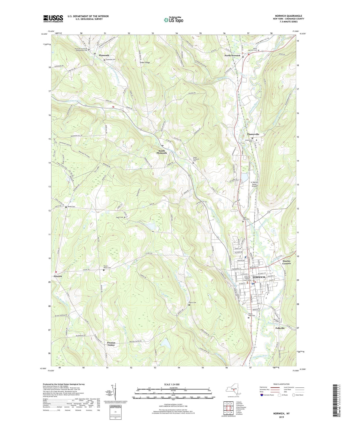
2023 topographic map quadrangle Norwich in the state of New York. Scale: 1:24000. Based on the newly updated USGS 7.5' US Topo map series, this map is in the following counties: Chenango. The map contains contour data, water features, and other items you are used to seeing on USGS maps, but also has updated roads and other features. This is the next generation of topographic maps. Printed on high-quality waterproof paper with UV fade-resistant inks.
Quads adjacent to this one:
West: East Pharsalia
Northwest: Otselic
North: Earlville
Northeast: Sherburne
East: Holmesville
Southeast: Guilford
South: Oxford
Southwest: Tyner
This map covers the same area as the classic USGS quad with code o42075e5.
Contains the following named places: Agape Baptist Church, Assembly of God Church, Broad Street Methodist Church, Calvary Baptist Church, Canasawacta Creek, Canasawacta Golf and Country Club, Chenango County Court House, Chenango County Historical Society, Chenango County Home Preston Manor, Chenango County Office Building, Chenango Memorial Hospital Residential Health Care Facility, Chenango Valley Home For Aged Women, Christ Lutheran Church, Christian Missionary Alliance, City of Norwich, Cold Brook, Colonia Theatre, East Branch Canasawacta Creek, East Park, Emmanuel Episcopal Church, First Baptist Church, First Congregational Church, Fly Creek, Free Methodist Church, Galena, German Hollow, Grace View Manor Assisted Living Facility, Guernsey Homestead Memorial Library, Harris Cemetery, Hawley Corners, Heady Cemetery, Johnson Creek, Lambs Quarters Organic Farm, Lt Warren Eaton Airport, Maple Grove East, Mead Pond, Mount Hope Cemetery, New Beginnings Church, North Norwich, North Norwich Cemetery, North Norwich Fire Department, North Norwich Post Office, Norwich, Norwich City Hall, Norwich Club, Norwich Drive-In, Norwich Fire Department, Norwich High School, Norwich Jewish Center, Norwich Middle School, Norwich Post Office, Packer - Mason Cemetery, Peacock Park, Pearl and Everett Gilmour Health Care Facility, Perry Browne Intermediate School, Plasterville, Plasterville Cemetery, Plymouth, Plymouth Fire District Volunteer Fire Department, Plymouth Northside Presbyterian Cemetery, Plymouth Post Office, Polkville, Preston, Preston Center, Preston Volunteer Fire Department, Ransford Creek, Saint Bartholomew's Roman Catholic Church, Saint Pauls Cemetery, Saint Pauls Parochial School, Saint Paul's Roman Catholic Church, School Number 1, School Number 11, School Number 12, School Number 2, School Number 3, School Number 4, School Number 5, School Number 6, School Number 8, School Number 9, Seventh Day Adventist Church, Slater Cemetery, South Plymouth, South Plymouth Cemetery, South Plymouth Post Office, Southside Cemetery, Stanford J Gibson Primary School, Stuart Corners, The Church of Jesus Christ of Latter Day Saints, Thompson Creek, Tinker Ridge, Town of Plymouth, Town of Preston, UHS Chenango Memorial Hospital, United Methodist Homes Doris L Patrick Campus, Valley Heights Christian Academy, Valley View Manor Nursing Home, Valley View Mobile Home Park, Ward School Number 1, Ward School Number 2, Ward School Number 3, Ward School Number 4, Ward School Number 5, West Park, Whapanaka Brook, Woods Corners, ZIP Code: 13815