MyTopo
Owego New York US Topo Map
Couldn't load pickup availability
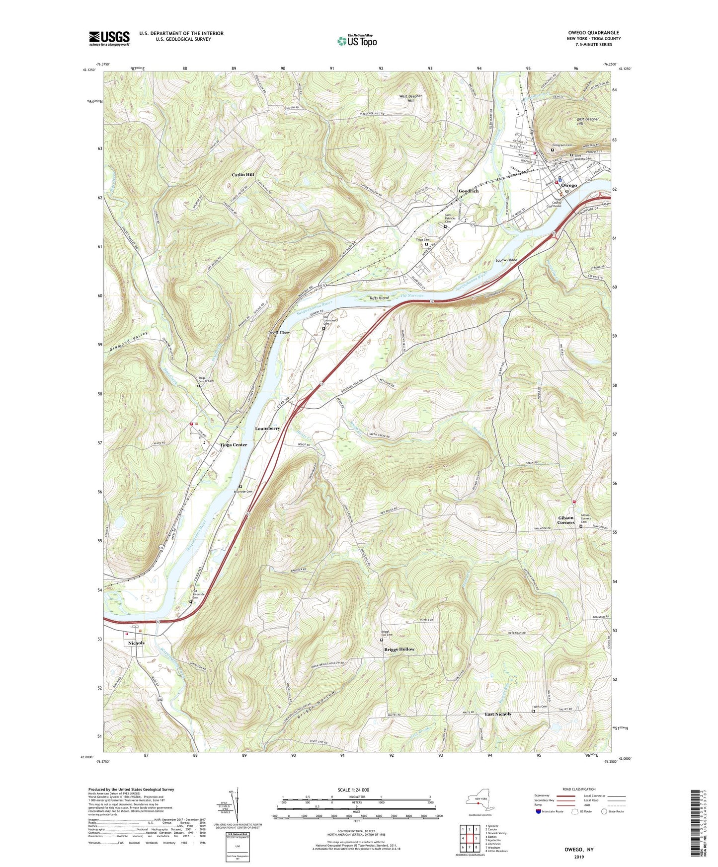
2023 topographic map quadrangle Owego in the state of New York. Scale: 1:24000. Based on the newly updated USGS 7.5' US Topo map series, this map is in the following counties: Tioga. The map contains contour data, water features, and other items you are used to seeing on USGS maps, but also has updated roads and other features. This is the next generation of topographic maps. Printed on high-quality waterproof paper with UV fade-resistant inks.
Quads adjacent to this one:
West: Barton
Northwest: Spencer
North: Candor
Northeast: Newark Valley
East: Apalachin
Southeast: Little Meadows
South: Windham
Southwest: Litchfield
This map covers the same area as the classic USGS quad with code o42076a3.
Contains the following named places: Airways Mobile Home Park, Albro Pit, Allen Glen, Assembly of God Church, Bridge of Hope Ministries, Briggs Hill Cemetery, Briggs Hollow, Catatonk Creek, Catlin Hill, Church of the Nazarene, Coburn Free Library, Devils Elbow, Diamond Valley, Draper Park, Dry Brook, East Beecher Hill, East Nichols, Evergreen Cemetery, First Baptist Church of Owego, First Presbyterian Church, First Presbyterian Union Church, First Presbyterian Union Church Cemetery, George P and Susan Platt Cady Library, Gibson Corners, Gibson Corners Cemetery, Gibson Corners United Methodist Church, Glenmary Mobile Home Park, Goodrich, Gospel Chapel, Heart of God's Fellowship Church, Horton Crossing, Huntington Creek, Hunts Creek, Hyde Park, Kirby Park, Livingston Park, Lounsberry, Lounsberry United Methodist Church, Maple Shade Trailer Park, Marvin Park, Mountain Top Greenhouses, Mountain View Mobile Home Park, Nichols, Nichols Baptist Church, Nichols Elementary School, Nichols Fire Department, Nichols United Methodist Church, Old Lounsberry Cemetery, Old Riverside Cemetery, Owego, Owego Creek, Owego Elementary School, Owego Fire Department Emergency Squad, Owego Fire Department Station 1, Owego Free Academy, Owego Northbound Rest Area, Owego Pit, Owego Post Office, Owego United Methodist Church, Owego Village Sewage Treatment Plant, Owego-Apalachin Middle School, Pipe Creek, Pumpelly Creek, Reformed Presbyterian Church, Riverside Cemetery, Saint Josephs Cemetery, Saint Patrick School, Saint Patricks Cemetery, Saint Patrick's Church, Saint Paul's Episcopal Church, Smith Creek, South Side Fire Department, Squaw Island, Sulphur Springs Chapel, Sunnyside Farm, Sword And The Spirit Christian Church, The Church of Jesus Christ of Latter Day Saints, The Narrows, Thorn Hollow, Tioga Airport, Tioga Cemetery, Tioga Center, Tioga Center Baptist Church, Tioga Center Cemetery, Tioga Center Christian School, Tioga Center Fire Department, Tioga Center United Methodist Church, Tioga Country Club, Tioga County Court House, Tioga Elementary School, Tioga Middle School, Tioga Senior High School, Town of Nichols, Town of Tioga, Tuffs Island, Village of Nichols, Village of Owego, Waits, Waits Cemetery, Wappasening Creek, WEBO-AM (Owego), West Beecher Hill, Wildrose Farm, Zion Lutheran Church, Zion Lutheran School, ZIP Codes: 13812, 13845