MyTopo
Peach Lake New York US Topo Map
Couldn't load pickup availability
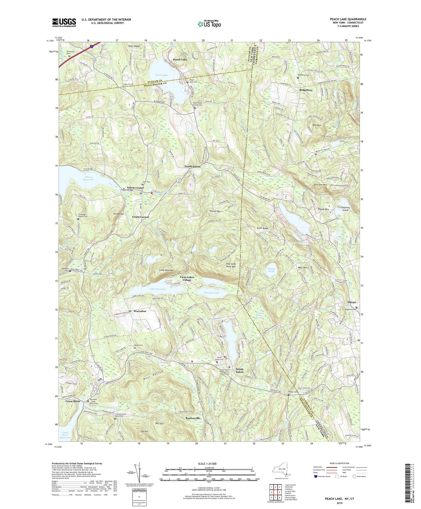
2023 topographic map quadrangle Peach Lake in the states of New York, Connecticut. Scale: 1:24000. Based on the newly updated USGS 7.5' US Topo map series, this map is in the following counties: Westchester, Fairfield, Putnam. The map contains contour data, water features, and other items you are used to seeing on USGS maps, but also has updated roads and other features. This is the next generation of topographic maps. Printed on high-quality waterproof paper with UV fade-resistant inks.
Quads adjacent to this one:
West: Croton Falls
Northwest: Lake Carmel
North: Brewster
Northeast: Danbury
East: Bethel
Southeast: Norwalk North
South: Pound Ridge
Southwest: Mount Kisco
This map covers the same area as the classic USGS quad with code o41073c5.
Contains the following named places: Ballard Green, Ballard Park, Barlow Mountain Elementary School, Boutonville, Cable Corner, Cat Ridge Baptist Cemetery, Chase Meadows Farm, Chauncey Island, Colonel Enoch Avery Cemetery, Congregation of Notre Dame, Crane Corner, Crook Brook, Cross River, Cross River Post Office, Cross River Shopping Center, Croton Falls Fire District North Salem Station 2, Deer Hollow, Dibbles Log Cabin Corners, Dingle, Drewsclift Cemetery, East Long Pond Mountain, Field's Corners, Fitzgerald Field, Four Winds Westchester Campus, Fox Hill, Grant Corner, Halstead Cemetery, Hammond Museum, Hemlock Lake, Hidden Meadow Farms, John Jay High School, John Jay Middle School, June Cemetery, Keeler Cemetery, Lake Naraneka, Lake Naraneka Dam, Lake Rippowam, Lake Waccabuc, Lake Windwing, Lake Windwing Dam, Lakes West Census Designated Place, Lakeside Field Club, Laurel Lake, Lewisboro Elementary School, Lewisboro Library, Lewisboro Police Department, Lobdell Corner, Long Pond Mountain, Long Pond Preserve, Mamanasco Lake, Mamanasco Lake Census Designated Place, Mamanasco Lake Dam, Mead Cemetery, Mead Memorial Chapel, Mill River, Mill's Bridge, Mopus Brook, Mountain Lakes Camp, Ned Mountain, North Salem, North Salem Central High School - Middle School, North Salem Post Office, North Salem Town Hall, North Salem Vineyard, Oscaleta Lake, Peach Lake, Peach Lake Cemetery, Peach Lake Census Designated Place, Peach Lake Meetinghouse, Peach Pond Friends Cemetery, Pehquenaknock Country Club, Pell Hill, Pequenakonck Elementary School, Peter Parley School, Pine Lake, Pine Tree Corner, Pumping Station Swamp, Reynolds - Cross River Cemetery, Richardson Park, Ridgebury, Ridgebury Cemetery, Ridgebury Census Designated Place, Ridgebury Congregational Church, Ridgebury Elementary School, Ridgefield Cemetery, Ridgefield Christian Center Church, Ridgefield Fire Department Station 2, Ridgefield Golf Course, Ridgefield High School, Ridgefield Montessori School, Ridgefield Post Office, Round Mountain, Round Pond, Ruth Keeler Memorial Library, Sachem Hill Field, Saint Elizabeth Seton Church, Saint Johns Church, Saint John's Episcopal Church, Saint Marys Roman Catholic Church, Saint Marys School, Salem Center, Salem Golf Club, Scotland Elementary School, Scott Ridge, Seth Low Mountain, Shadow Lake, Shadow Lake Dam, Silver Spring Country Club, South Salem, South Salem Cemetery, South Salem Fire Department, South Salem Post Office, South Salem Presbyterian Church, South Salem Presbyterian Church Cemetery, Spruce Lake, Temple Shearith Israel, Titicus, Titicus Mountain, Titicus River, Town of Lewisboro, Town of North Salem, Town of Ridgefield, Truesdale Lake, Turkey Hill, Turtle Pond, Twin Lakes Village, Vails Grove Golf Course, Waccabuc, Waccabuc Country Club, Waccabuc Post Office, Waccabuc River, West Mountain, West Mountain Census Designated Place, West Mountain Refuge, Whatmores Lake, Yerkes Corner, ZIP Codes: 10518, 10560, 10590, 10597