MyTopo
Alarka North Carolina US Topo Map
Couldn't load pickup availability
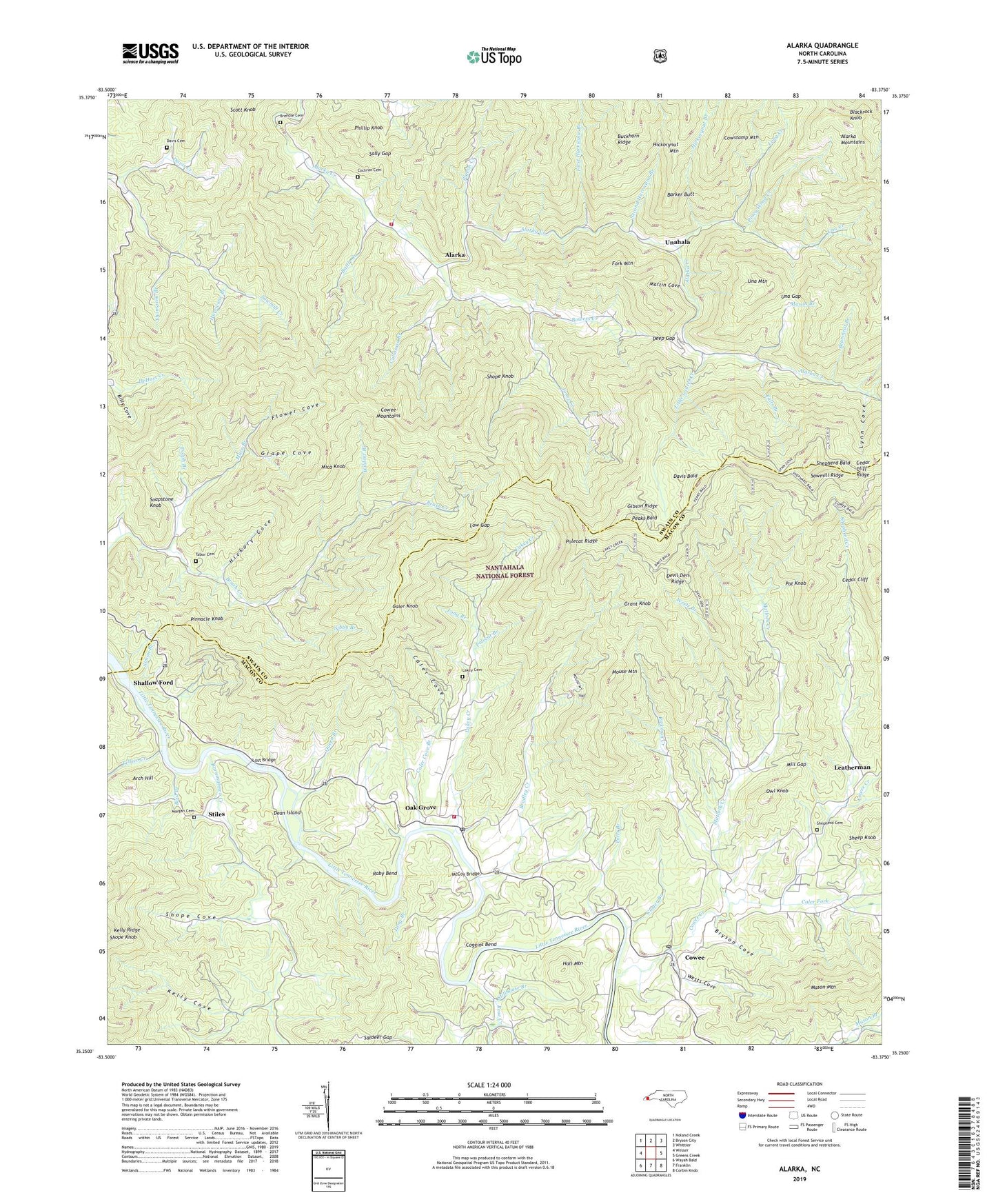
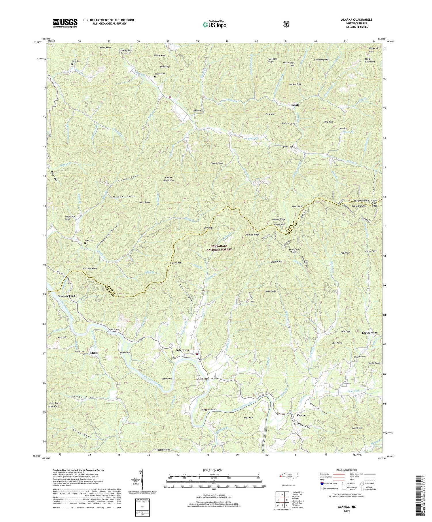
2019 topographic map quadrangle Alarka in the state of North Carolina. Scale: 1:24000. Based on the newly updated USGS 7.5' US Topo map series, this map is in the following counties: Swain, Macon. The map contains contour data, water features, and other items you are used to seeing on USGS maps, but also has updated roads and other features. This is the next generation of topographic maps. Printed on high-quality waterproof paper with UV fade-resistant inks.
Quads adjacent to this one:
West: Wesser
Northwest: Noland Creek
North: Bryson City
Northeast: Whittier
East: Greens Creek
Southeast: Corbin Knob
South: Franklin
Southwest: Wayah Bald
Contains the following named places: Alarka, Alarka School, Alarka Volunteer Fire Department, Arch Hill, Barker Butt, Battle Creek, Bearmeat Branch, Billy Cove, Bird Branch, Blackrock Knob, Bonanza Mine, Bowers Creek, Bradley Creek, Brendle Cemetery, Brush Creek School, Bryson Cove, Burningtown Creek, Caler Cove, Caler Cove Branch, Caler Creek Ruby Mine, Caler Fork, Caler Knob, Carter Branch, Cedar Cliff, Cedar Cliff Ridge, Cochran Cemetery, Cochran Church, Coggins Bend, Cold Spring Branch, Cowee, Cowee Church, Cowee Creek, Cowee School, Cowee Volunteer Fire and Rescue Department Substation, Cullasaja Branch, Dale and Demkos Mine, Davis Bald, Davis Cemetery, Davis Creek, Dean Island, Deep Gap, Deep Gap Church, Devil Den Ridge, Dolph Branch, Etna Post Office, Falls Branch, First Hurricane Branch, Flower Cove, Fork Mountain, Gibby Branch, Gibson Ridge, Gibsons Ruby Mine, Grant Knob, Grape Cove, Hall Mountain, Hickory Cove, Hickorynut Branch, Hurricane Branch, Jacobs Mine, Jones Creek, Jones Ruby Mine, Kelly Cove, Kelly Ridge, Lakey Cemetery, Lakey Creek, Leatherman, Little Laurel Creek, Long Branch, Long Creek, Lost Bridge, Low Gap, Lynn Cove, Marr Branch, Martin Cove, Mason Branch, Matlock Creek, McCoy Bridge, McCoys Fishing Lake, Mica Knob, Mill Gap, Morgan Cemetery, Mount Vernon Church, Mouse Mountain, Oak Grove, Owl Knob, Pat Knob, Peaks Bald, Phillip Knob, Pigeon Creek, Piney Wood Creek, Pinnacle Knob, Pleasant Hill Church, Polecat Branch, Polecat Ridge, Potts Branch, Pyle Dam, Pyle Lake, Queen Branch, Raby Bend, Rickman Creek, Rose Creek, Rose Creek Church, Saldeer Gap, Sally Gap, Sawmill Ridge, Scott Knob, Second Hurricane Branch, Shallow Ford, Sheffield Mine, Shepherd Bald, Shepherd Cemetery, Shepherd Creek, Shope Cove, Shope Knob, Simon Branch, Snow Hill Church, Soapstone Knob, Stiles, Stillhouse Branch, Tabor Cemetery, Tellico Creek, Thomason Branch, Township of Cowee, Una Creek, Una Gap, Unahala, Upper Long Creek, Wests Branch, Wests Cove, Wests Mill Post Office, White Oak School, Wildcat Branch, Yukon Mine, ZIP Code: 28713