MyTopo
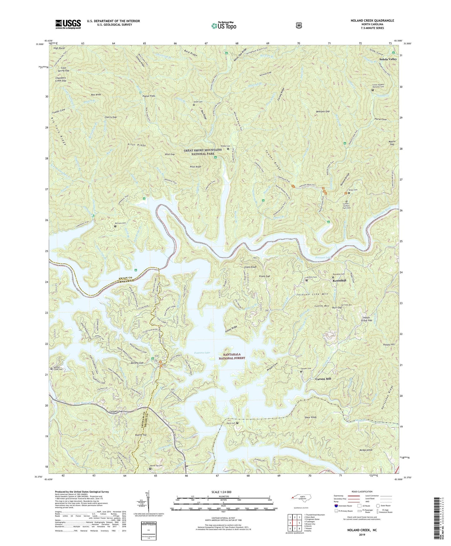
Noland Creek North Carolina US Topo Map
Couldn't load pickup availability
Also explore the Noland Creek Forest Service Topo of this same quad for updated USFS data
2022 topographic map quadrangle Noland Creek in the state of North Carolina. Scale: 1:24000. Based on the newly updated USGS 7.5' US Topo map series, this map is in the following counties: Swain, Graham. The map contains contour data, water features, and other items you are used to seeing on USGS maps, but also has updated roads and other features. This is the next generation of topographic maps. Printed on high-quality waterproof paper with UV fade-resistant inks.
Quads adjacent to this one:
West: Tuskeegee
Northwest: Thunderhead Mountain
North: Silers Bald
Northeast: Clingmans Dome
East: Bryson City
Southeast: Alarka
South: Wesser
Southwest: Hewitt
This map covers the same area as the classic USGS quad with code o35083d5.
Contains the following named places: Advalorem Branch, Alarka Creek, Alarka Dock, Almond Park Dock, Almond Post Office, Ammons Branch, Andreas Branch, Anthony Branch, Battles Branch, Bear Creek, Bearpen Branch, Bearpen Gap, Bee Gum Branch, Bee Knob, Bee Ridge, Big Branch, Brewer Branch, Burnett Branch, Calfpen Gap, Canebrake Branch, Carson Mill, Chambers Branch, Chambers Creek Gap, Cherry Branch, Cherry Gap, Cold Spring Gap, Collins Mountain, Connor - Hickory Flats Cemetery, Dark Branch, Davis Branch, Davis Cemetery, Dowell Dock, Drinklog Branch, Evans Gap, Evans Knob, Fishtrap Branch, Flat Branch, Flat Branch Launch Site, Flint Gap, Forney Creek, Fowler Cove, Glady Branch, Goldmine Branch, Grant Branch, Grassy Branch, Gray Wolf Creek, Greasy Branch, Greasy Branch Dock, Gunter Branch, Hickory Flat Branch, High Rocks, Hogpen Branch, Holder Cove Branch, Horse Branch, Horse Cove, Horseshoe Ridge, Hoyle Cemetery, Hurricane Mountain, Hyatt Branch, Indian Creek, Indian Grave Gap, Indian Ridge, Jackson Line Mountain, Jenkins Branch, Jenkins Cemetery, Jenny Branch, Jumpup Ridge, Kate Branch, Laurel Branch, Lemmons Branch, Little Horse Branch, Lower Noland - Monteith Cemetery, Massie Gap, McClure Cemetery, McHan Knob, Meadow Branch, Midway Church, Mill Creek, Mount Zion Church, Mouse Branch, Murphy Branch, Murphy Gap, Nantahala River, Noland Creek, North Fork Chambers Creek, Panther Creek, Panther Creek Cemetery, Panther Creek Church, Phipps Cove, Pilot Gap, Pilot Knob, Pilot Ridge, Pole Bridge Branch, Poplar Cove, Poplar Flats, Poplar Pole Branch, Potato Hill, Reeny Branch, Rich Gap, Rinehart and White Dock, Round Top, Round Top Cemetery, Roundhill, Roundhill Cemetery, Sawyer Cemetery, Sawyer Dock, Shear Knob, Slab Cove, Solola Valley, Springhouse Branch, Stevenson Branch, Stiles Cemetery, Swain County Park, Town Branch, Tsali Campground, Tsali Horse Trail, Tuckasegee River, Tunnel Branch, Tunnel Ridge, Turkey Branch, Watertank Branch, Welch Branch, West Fork Chambers Creek, Whiteoak Branch, Whiteoak Ridge, Wolf Creek, Woody Cemetery, ZIP Code: 28702