MyTopo
Franklin North Carolina US Topo Map
Couldn't load pickup availability
Also explore the Franklin Forest Service Topo of this same quad for updated USFS data
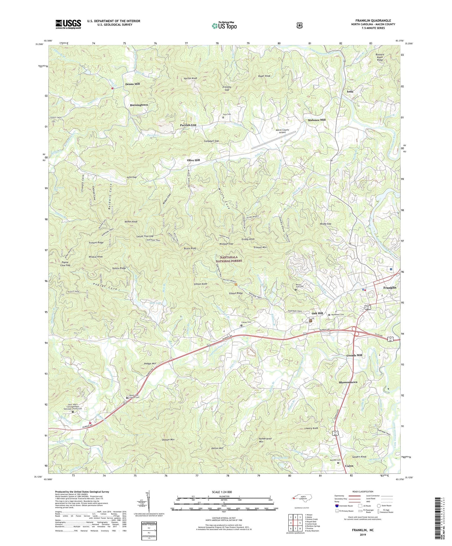
2022 topographic map quadrangle Franklin in the state of North Carolina. Scale: 1:24000. Based on the newly updated USGS 7.5' US Topo map series, this map is in the following counties: Macon. The map contains contour data, water features, and other items you are used to seeing on USGS maps, but also has updated roads and other features. This is the next generation of topographic maps. Printed on high-quality waterproof paper with UV fade-resistant inks.
Quads adjacent to this one:
West: Wayah Bald
Northwest: Wesser
North: Alarka
Northeast: Greens Creek
East: Corbin Knob
Southeast: Scaly Mountain
South: Prentiss
Southwest: Rainbow Springs
This map covers the same area as the classic USGS quad with code o35083b4.
Contains the following named places: Allen Branch, Angel Medical Center, Baldwin Cove, Blaine Branch, Blossomtown, Bruce Knob, Burningtown, Burningtown - Iotla Volunteer Fire and Rescue Department, Burningtown Dam, Burningtown Falls, Buzzard Roost Ridge, Campbell Gap, Carson Cemetery, Carson Chapel, Carson Cove, Cartoogechaye Church, Cartoogechaye Creek, Clanpit Cove, Cochran Cove, Cozads Mill, Dates Creek, Deans Mill, Dobson Branch, Dobson Mountain, Downes Branch, Edwards Branch, Fout Cemetery, Franklin, Franklin Fire and Rescue Department, Franklin Police Department, Franklin School, Gibson Cove Branch, Gibson Knob, Gibson Ridge, Grant Dam, Grant Lake, Grassy Knob, Gribble Branch, Hayes Mill Creek, Holiness Church, Horton Knob, Iotla, Iotla Branch, Iotla Church, Iotla Creek, Iotla Gap, Jacob Branch, Jones Cove, Jones Creek, Lenoir Branch, Locust Tree Gap, Longview Church, Louisa Chapel, Lowery Creek, Lowery Knob, Macon County, Macon County Airport, Macon County Emergency Medical Services - Franklin Station, Malonee Mill, Mason Branch, Mason Mountain Rhodolite Mine, Masons Sapphire Mine, Maxwell School, McDowell Branch, McGhee Cemetery, McKee Branch, Mill Creek, Miller Creek, Mint Branch, Mint Lake, Mint Lake Dam, Mount Hope Church, Mount Zion Cemetery, Mount Zion Church, Mount Zion Church Cemetery, Muskrat Creek, North Carolina State Prison Camp, Oak Hill, Oakdale School, Old Cardinal Mine, Olive Hill, Olive Hill School, Owenby Branch, Palmer Street Shopping Center, Parrish Creek, Parrish Gap, Patton Chapel, Patton Mountain, Pattons School, Pendergrass Mountain, Piney Grove Church, Podgys Mountain, Poindexter Branch, Poplar Cove, Poplar Cove Creek, Poplar Cove Gap, Potts Creek, Pressley Gap, Rocky Branch, Roper Knob, Rose Creek Mine, Saint Cyprian Church, Saint John's Cartoogechaye Episcopal Church Cemetery, Sanders Knob, Satser Branch, Shingletree Branch, Slagle Memorial Church, Slagle School, Tarkiln Ridge, Tippet Branch, Town of Franklin, Township of Franklin, Trimont Branch, Trimont Mountain, Tubb Quarry, Wallace Branch, Wayah Creek, Wayah Ranger District Office, West Macon Fire and Rescue, Wildcat Knob, Wildes Creek, Wilkes Cove, Wilkes Knob, Willis Cove, Windy Gap, Windy Gap Church, Wolfpen Gap, Woodlawn Cemetery, Younce Creek, ZIP Code: 28734