MyTopo
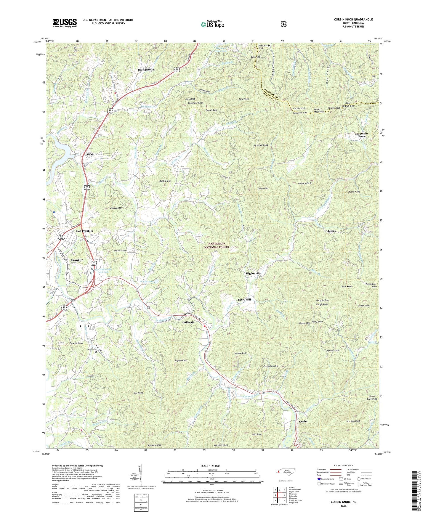
Corbin Knob North Carolina US Topo Map
Couldn't load pickup availability
Also explore the Corbin Knob Forest Service Topo of this same quad for updated USFS data
2022 topographic map quadrangle Corbin Knob in the state of North Carolina. Scale: 1:24000. Based on the newly updated USGS 7.5' US Topo map series, this map is in the following counties: Macon, Jackson. The map contains contour data, water features, and other items you are used to seeing on USGS maps, but also has updated roads and other features. This is the next generation of topographic maps. Printed on high-quality waterproof paper with UV fade-resistant inks.
Quads adjacent to this one:
West: Franklin
Northwest: Alarka
North: Greens Creek
Northeast: Sylva South
East: Glenville
Southeast: Highlands
South: Scaly Mountain
Southwest: Prentiss
This map covers the same area as the classic USGS quad with code o35083b3.
Contains the following named places: Ammons Branch, Angel Cemetery, Arnold Branch, Battle Branch, Berry Creek, Berry Mill, Bethel Church, Bethlehem Church, Brendletown, Brown Creek, Brown Gap, Bryson Branch, Bryson Knob, Buby Gap, Burgoin Gap, Buzzard Knob, Cat Creek, Cedar Knob, Clark Chapel, Clark Chapel School, Clarks Chapel Fire and Rescue Department, Coon Creek, Corbin Creek, Corbin Knob, Corundum Hill, Cove Branch, Cowee Mountain Mine, Cowee Mountains, Crawford Branch, Cross Branch, Cullasaja, Cullasaja Gorge Fire and Rescue Department, Cullasaja River, Dean, Deerlick Knob, Dills Knob, Dowdle Knob, East Franklin, East Franklin Shopping Center, Ellijay, Ellijay Church, Ellijay Creek, Elmore Branch, Falls Branch, Flat Branch Gap, Franklin Post Office, Gem City Mine, Gneiss, Guy Knob, Hickory Knob, Higdon Branch, Higdon Mountain, Higdon School, Higdonville, Hog Cove, Holly Springs Church, Holly Springs School, Houston Knob, Hughes Branch, Hyatt Knob, Indian Camp Branch, Jack Knob, Jacobs Knob, Jane Knob, Katie Creek, Keener Knob, Lake Emory, Lake Emory Dam, Laurel Creek, Laurel Gap, Laurel Valley Mine, Ledford Branch, Lickskillet Branch, Little Buck Creek, Lyle Knob Mine, Macon County Sheriff's Office, Mashburn Branch, Mashburn Branch School, Moore Knob, Moses Branch, Moss Branch, Mountain Grove, Mountain Valley Volunteer Fire and Rescue Department, Nickajack Creek, Nikwasi Indian Mound, North Prong Ellijay Creek, Oak Grove Church, Oak Ridge School, Onion Mountain, Passmore Knob, Peak Knob, Peeks Creek, Pine Grove Church, Pine Grove School, Pine Hill Trailer Park Dam, Pine Hill Trailer Park Lake, Porter Bend Dam, Porter Cove, Rabbit Creek, Rabbit Mountain, Rattlesnake Knob, Ridge Crest Church, Riley Knob, Rocky Face Mine, Rough Knob, Salem Church, Salem School, Sassafras Branch, Sassafras Gap, Scott Branch, Shansfield Branch, Shell Branch, Sloans Chapel, Sugar Fork Church, Thompson Branch, Township of Ellijay, Township of Millshoal, Turkey Knob, Walnut Creek, Walnut Creek Gap, Walnut Creek School, Watauga Church, Watauga Creek, Watauga School, Watauga Vista Dam, Watauga Vista Lake, Wells Grove Church, WFSC-AM (Franklin), Whites Lake, Whites Lake Dam, Wildcat Creek, WLTM-AM (Franklin), Wooten Mountain, WRFR-FM (Franklin), Young Cove