MyTopo
Bat Cave North Carolina US Topo Map
Couldn't load pickup availability
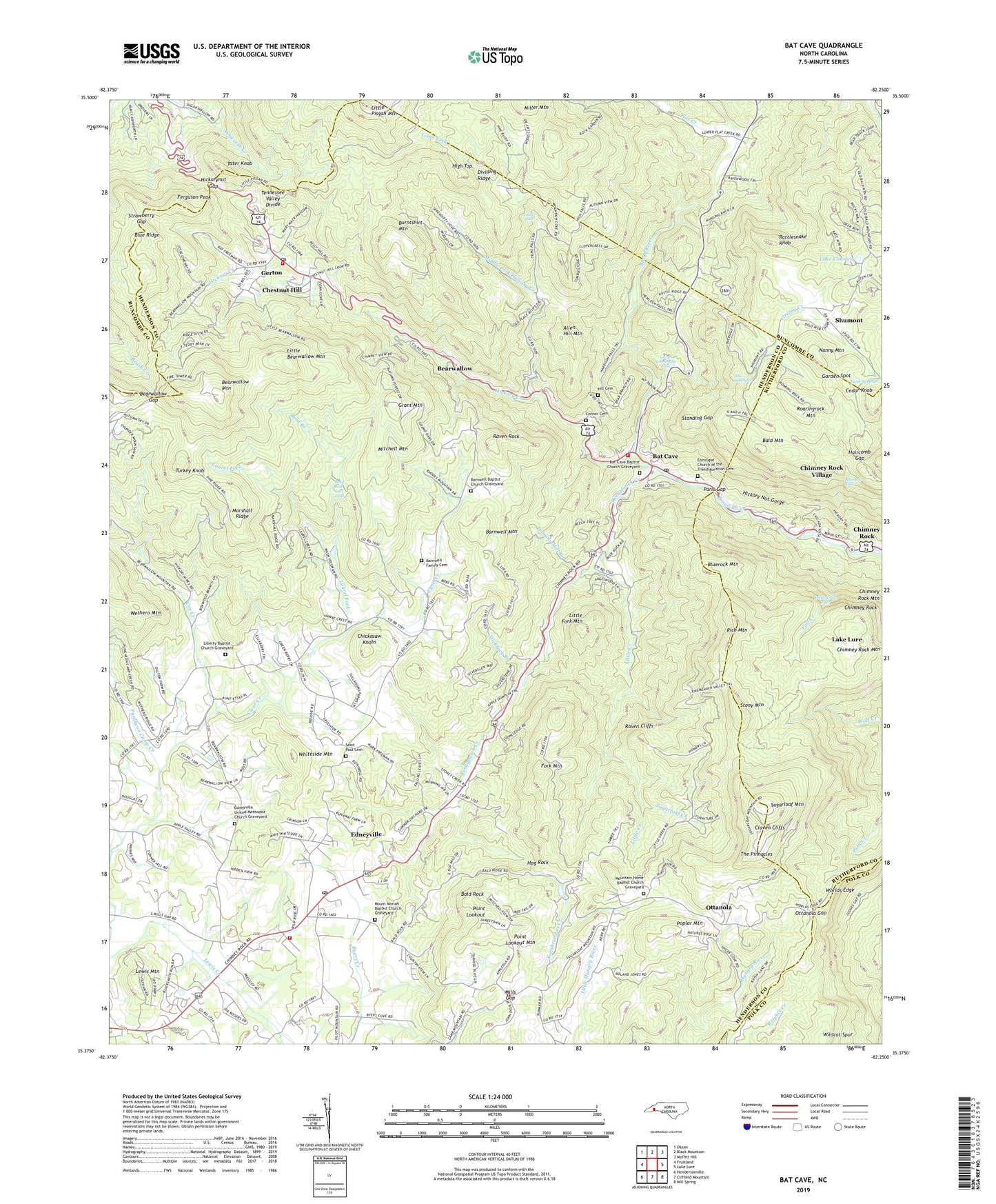
2019 topographic map quadrangle Bat Cave in the state of North Carolina. Scale: 1:24000. Based on the newly updated USGS 7.5' US Topo map series, this map is in the following counties: Henderson, Buncombe, Rutherford, Polk. The map contains contour data, water features, and other items you are used to seeing on USGS maps, but also has updated roads and other features. This is the next generation of topographic maps. Printed on high-quality waterproof paper with UV fade-resistant inks.
Quads adjacent to this one:
West: Fruitland
Northwest: Oteen
North: Black Mountain
Northeast: Moffitt Hill
East: Lake Lure
Southeast: Mill Spring
South: Cliffield Mountain
Southwest: Hendersonville
Contains the following named places: Allen Hill Mountain, Bald Mountain, Bald Mountain Church, Bald Rock, Barnwell Baptist Church Graveyard, Barnwell Church, Barnwell Family Cemetery, Barnwell Mountain, Bat Cave, Bat Cave Baptist Church Graveyard, Bat Cave Post Office, Bat Cave Volunteer Fire and Rescue Department, Bead and Lace Falls, Bearwallow, Bearwallow Church, Bearwallow Gap, Bearwallow Mountain, Bluerock Mountain, Bold Branch, Burntshirt Mountain, Camp Minnehaha Falls, Cedar Knob, Chestnut Hill, Chickasaw Knobs, Chimney Rock, Chimney Rock Mountain, Chimney Rock Park, Chinquapin Gap, Cloven Cliffs, Conner Cemetery, Coon Branch, Cox Creek, Dividing Ridge, Edneyville, Edneyville Census Designated Place, Edneyville Church, Edneyville Fire and Rescue Station 1, Edneyville Fire and Rescue Station 3, Edneyville Post Office, Edneyville United Methodist Church Graveyard, Episcopal Church of the Transfiguration Cemetery, Esmeralda, Fall Creek, Ferguson Peak, Flat Creek, Fork Mountain, Garden Spot, Gerton, Gerton Census Designated Place, Gerton Post Office, Gerton Volunteer Fire Department and Rescue, Grant Mountain, Grassy Creek, Haircomb Gap, Hickory Creek, Hickorynut Falls, Hickorynut Gap, High Top, Hill Cemetery, Hog Rock, Hominy Mill Branch, Lake Charles, Laurel Fork, Lewis Mountain, Liberty Baptist Church Graveyard, Liberty Church, Little Bearwallow Mountain, Little Creek, Little Fork Mountain, Marshall Ridge, Maxwell Mill, Middle Fork Church, Middle Fork Hickory Creek, Miller Mountain, Mills Gap, Mitchell Mountain, Mount Moriah Baptist Church Graveyard, Mount Moriah Church, Mountain Home Baptist Church Graveyard, Mountain Home Church, Nanny Mountain, Ottanola, Ottanola Gap, Paris Gap, Point Lookout, Point Lookout Mountain, Poplar Mountain, Puncheon Camp Creek, Rainbow Falls, Rattlesnake Knob, Raven Cliffs, Raven Rock, Reedypatch Creek, Rich Mountain, Roaringrock Mountain, Runaway Farm Lake, Runaway Farm Lake Dam, Saint Paul Cemetery, Saint Pauls Church, Saint Peters Church, Saint Peters School, Shumont, Slickrock Branch, Standing Gap, Stony Mountain, Strawberry Gap, Sugarloaf Creek, Sugarloaf Mountain, Tater Knob, The Cascades, The Pinnacles, Toms Falls, Toms Fork, Township of Edneyville, Turkey Knob, Turnbreeches Creek, Twin Springs, Village of Chimney Rock Village, Whiteside Mountain, Worlds Edge, ZIP Codes: 28720, 28735, 28792