MyTopo
Gastonia North North Carolina US Topo Map
Couldn't load pickup availability
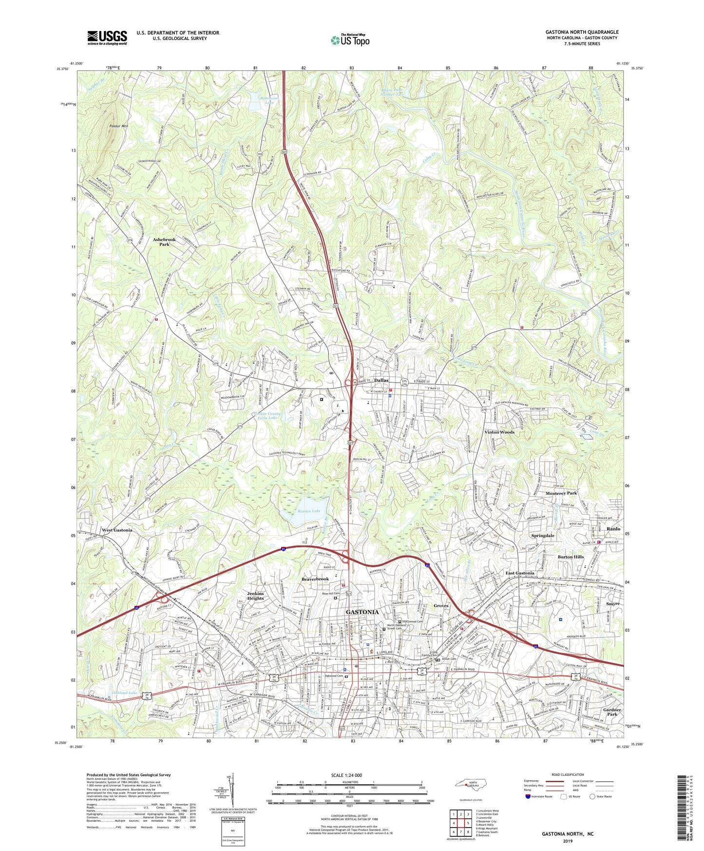
2022 topographic map quadrangle Gastonia North in the state of North Carolina. Scale: 1:24000. Based on the newly updated USGS 7.5' US Topo map series, this map is in the following counties: Gaston. The map contains contour data, water features, and other items you are used to seeing on USGS maps, but also has updated roads and other features. This is the next generation of topographic maps. Printed on high-quality waterproof paper with UV fade-resistant inks.
Quads adjacent to this one:
West: Bessemer City
Northwest: Lincolnton West
North: Lincolnton East
Northeast: Lowesville
East: Mount Holly
Southeast: Belmont
South: Gastonia South
Southwest: Kings Mountain
This map covers the same area as the classic USGS quad with code o35081c2.
Contains the following named places: Abernathy School, Agriculture Center Volunteer Fire Department, Akers Shopping Center, Antioch Church, Arlington Junior High School, Ashebrook Park, Ashley High School, Beaverbrook, Bright Light Church, Burton Branch, Burton Hills, CaroMont Regional Medical Center, Carr School, Coley Creek, Costner School, Craig Family Cemetery, Dallas, Dallas Elementary School, Dallas Police Department, Dallas Post Office, Dallas Rescue Squad, Dallas Volunteer Fire Department Station 63, Dixie Village Shopping Center, East Gastonia, East Ridge Shopping Center, Erwin Park, Evans Lake, Firestone Field, Flint Groves School, Flyer Park, Franklin Shopping Center, Friendly Church, Gardner Park, Gardner Park Elementary School, Gaston College, Gaston Correctional Center, Gaston County, Gaston County Farm Lake, Gaston County Farm Lake Dam, Gaston County Police Department, Gaston County Schools Administration, Gaston County Sheriff's Office, Gaston Landfill, Gaston Lifesaving Crew, Gaston Mall, Gaston Park, Gaston Square Shopping Center, Gastonia, Gastonia Central Elementary School, Gastonia City Fire Department Station 1, Gastonia City Fire Department Station 2, Gastonia City Fire Department Station 6, Gastonia Post Office, Gingles School, Grace Church, Grier Junior High School, Groves, Highland Junior High School, Hollywood Cemetery, Hoyle Creek, Hoylesville, Jenkins Heights, Jule Allen Branch, Kaglor Branch, Lineburger Park, Little Hoyle Creek, Long Creek Memorial Church, Long Creek Sewage Disposal, Loray Mills, Love Park, Mauney Creek, Midway Church, Modena Church, Monterey Park, Mount Olivet Church, Mountain View Church, Myrtle School, Nichols Shopping Center, North Carolina State Highway Patrol Troop H District 1, North Gaston Senior High School, North Gastonia, North Oakland Street Cemetery, North Park, Northside Church, Oakland Lake, Oakland Park, Oakwood Cemetery, Oates Creek, Ozark, Parkwood Church, Pasour Mountain, Peedin School, Philadelphia Church, Plainview Church, Powell Glennwood Shopping Center, Puett Church, Ragan Church, Rankin Lake, Rankin Lake Dam, Rankin Lake Park, Ranlo, Ranlo Fire and Rescue Station 19, Rhyne Lake Dam Number Two, Rhyne Lake Number Two, Rhyne School, Robinsons Lake, Robinsons Lake Dam, Rose Hill Cemetery, Saint Johns Church, Schiele Museum, Shiloh Cemetery, Sims Park, Smyre, Spencer Mountain Road Volunteer Fire Department, Springdale, Springdale Census Designated Place, Town of Dallas, Town of Ranlo, Town of Ranlo Police Department, Township of Dallas, Vinton Woods, WAAK-AM (Dallas), Walnut Grove Church, Warlick School, Water Tower Center, WBTV-TV (Charlotte), WCCB-TV (Charlotte), West Gastonia, West Gastonia Industrial Park, WGNC-AM (Gastonia), William C Friday Junior High School, Wilson School, Windsor Park Shopping Center, WLTC-AM (Gastonia), Woodhill School, WPCQ-TV (Charlotte), Wray Junior High School, WSGE-FM (Dallas), WSOC-TV (Charlotte), ZIP Codes: 28034, 28054