MyTopo
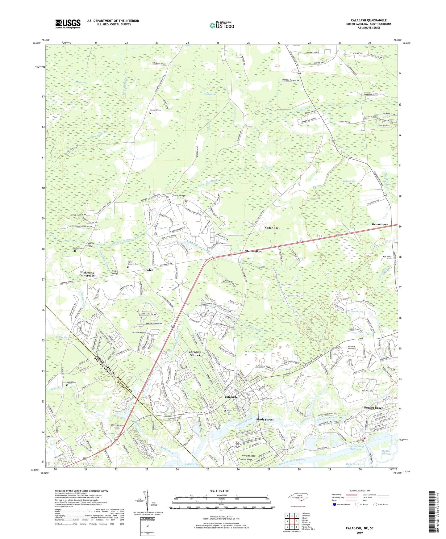
Calabash North Carolina US Topo Map
Couldn't load pickup availability
2022 topographic map quadrangle Calabash in the states of North Carolina, South Carolina. Scale: 1:24000. Based on the newly updated USGS 7.5' US Topo map series, this map is in the following counties: Brunswick, Horry, Columbus. The map contains contour data, water features, and other items you are used to seeing on USGS maps, but also has updated roads and other features. This is the next generation of topographic maps. Printed on high-quality waterproof paper with UV fade-resistant inks.
Quads adjacent to this one:
West: Longs
Northwest: Pireway
North: Freeland
Northeast: Exum
East: Shallotte
Southeast: Shallotte OE S
South: Little River
Southwest: Wampee
Contains the following named places: Andrew Chapel, Bennett Cemetery, Bethel Church, Beulah Church, Blane Landing, Blanes Landing, Blanton Cemetery, Bonaparte Landing, Boundary Creek, Brunswick County Emergency Medical Services Base 6, Calabash, Calabash Creek, Calabash Fire Department Station 12 - 1 Headquarters, Calabash Fire Department Station 12 - 2, Calabash Post Office, Calabash River, Carolina Shores, Carolina Shores Golf and Country Club, Cawcaw Bridges, Cedar Bay, Corkins Neck, Cypress Bay Golf Course, Doghead Bay, Drowned Bay, Earnest Branch, First Apostolic Church, Friendship Church, Greenbriar Lake, Grissettown, Grissettown - Longwood Fire and Rescue, Heather Glen Golf Course, Hickmans Branch, Hickmans Crossroads, Iredell, Iredell Bridge, Jinks Landing, La Savannah School, Lewis Cemetery, Little Cawcaw Swamp, Little River Medical Center, Little River School, Little River United Methodist Church, Little River Village Shopping Center, Manley Bennett Cemetery, Marys Landing, Milliken Cove, Mullet Creek, Old Shallotte, Oyster Bay Golf Links, Pearl Golf Links, Persimmon Swamp, Pleasant Grove Church, Pleasant View Cemetery, Pleasant View Church, Saint Andrew Church, Sea Trail Golf Links, Shady Forest, Shingletree Bridges, Shingletree Swamp, Smith Bridges, South Carolina Noname 26020 D-3623 Dam, Stanland Bay, Stanland Branch, Sunset Beach, Sunset Beach Fire Station 11 - 1, Sunset Beach Post Office, The Big Narrows, Thomas Bay, Thomasboro, Town of Calabash, Town of Carolina Shores, Town of Sunset Beach, United Church, Wesleyan Church, Wilson Cemetery, ZIP Codes: 28452, 28467, 28468