MyTopo
Henderson North Carolina US Topo Map
Couldn't load pickup availability
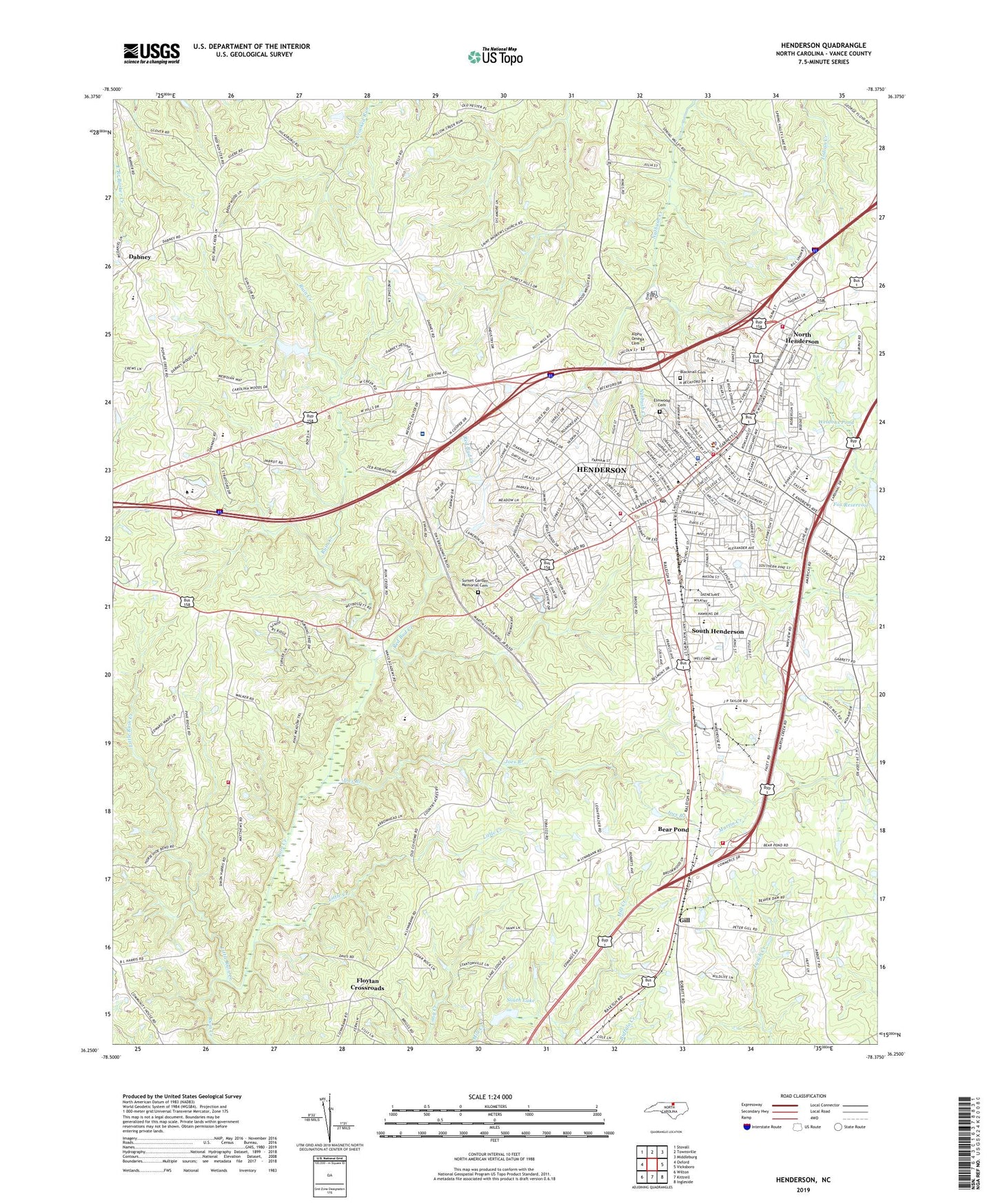
2019 topographic map quadrangle Henderson in the state of North Carolina. Scale: 1:24000. Based on the newly updated USGS 7.5' US Topo map series, this map is in the following counties: Vance. The map contains contour data, water features, and other items you are used to seeing on USGS maps, but also has updated roads and other features. This is the next generation of topographic maps. Printed on high-quality waterproof paper with UV fade-resistant inks.
Quads adjacent to this one:
West: Oxford
Northwest: Stovall
North: Townsville
Northeast: Middleburg
East: Vicksboro
Southeast: Ingleside
South: Kittrell
Southwest: Wilton
Contains the following named places: Alpha Omega Cemetery, Bear Pond, Bearpond Volunteer Fire Department, Blacknall Cemetery, Chestnut Street Park, City of Henderson, Clark Street School, Corbitt Hill Shopping Center, Country Place, Croatan Club Building, Dabney, Dabney Drive Shopping Center, Dabney Elementary School, Deadstick Airport, Eaton-Johnson Junior High School, Eaton-Johnson Park, Elmwood Cemetery, Floytan Crossroads, Fuller Chapel, Garnett Street Station, Gill, Glover House, H Leslie Perry Library, Hale House, Harriet Church, Harris Chapel, Henderson, Henderson Country Club, Henderson Fire Department Station 1, Henderson Fire Department Station 2, Henderson Institute Historical Building, Henderson Junior High School, Henderson Police Department, Henderson Post Office, Henry A Dennis County Office Building, Herman United Methodist Church, Hunters Ridge, Jackson Park, Joes Branch, Kings Daughters Park, Little Creek, Little Ruin Creek, Maria Parham Medical Center, Mistletoe Villa, Mount Moriah Church, North Carolina State Highway Patrol Troop C District 4, North Henderson, North Henderson Park, Nutbush Church, Oak Grove School, Outlet City Shopping Center, Owen Davis Park, Pinkston Park, Pinkston Street Elementary School, Poplar Creek Church, Raleigh Road Church, Red Bud Creek, Rollins School, Saint Andrews Church, Saint Johns Church, Saint Pauls Church, Seaman Way, South Henderson, South Henderson Census Designated Place, South Henderson Park, South Henderson Pentecostal Holiness Church, South Lake, South Lake Dam, Spring Valley Church, Sunset Garden Memorial Cemetery, Township of Dabney, Township of Henderson, Township of Watkins, Vance Academy, Vance County, Vance County Arts Council Building, Vance County Court House Building, Vance County Fire Department and Emergency Services, Vance County Health Center, Vance County Historical Museum, Vance County Rescue Squad, Vance County Sheriff's Office, Vance County Tourism Office, Vance Industrial Park, Vance Square, Vance-Granville Community College, Vance-Granville Technical Institute Pond Dam, Vancey School, Watkins Volunteer Fire Department, Welcome Chapel, Weldons Pond, Westwood Hills, WHNC-AM (Henderson), Willow Oaks, WIZS-AM (Henderson), WYFL-FM (Henderson), ZIP Codes: 27536, 27537