MyTopo
Morganton South North Carolina US Topo Map
Couldn't load pickup availability
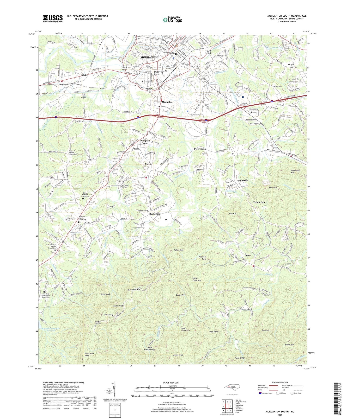
2022 topographic map quadrangle Morganton South in the state of North Carolina. Scale: 1:24000. Based on the newly updated USGS 7.5' US Topo map series, this map is in the following counties: Burke. The map contains contour data, water features, and other items you are used to seeing on USGS maps, but also has updated roads and other features. This is the next generation of topographic maps. Printed on high-quality waterproof paper with UV fade-resistant inks.
Quads adjacent to this one:
West: Glen Alpine
Northwest: Oak Hill
North: Morganton North
Northeast: Drexel
East: Valdese
Southeast: Casar
South: Benn Knob
Southwest: Dysartsville
This map covers the same area as the classic USGS quad with code o35081f6.
Contains the following named places: Bailey Fork, Bethel Cemetery, Bethel Church, Bethel Road Park, Bethlehem Church, Black Fox Ridge, Bob Knob, Brookwood Baptist Church, Broughton Hospital, Burke County, Burke County Emergency Services Station 1, Burke County Human Resources Center, Burke County Sheriff's Office, Burke Memorial Park Cemetery, Burkeley Square, Burkemont, Burkemont Baptist Church, Burkemont Mountain, Calvin, Canoe Creek, Carbon City Park, Carolinas Healthcare System Blue Ridge Morganton, Cedar Mountain, Chambers, City of Morganton, Clyde Valley Airport, Collett Street Recreation Center, Cross Memorial Church, Deaton Chapel, East Prong Hunting Creek, Enola, Enola Fire and Rescue Department, Fiddlers Run, Foothills Correctional Institution, Forest Hill Elementary School, Freedom High School, Freedom Park, Gilboa Church, Gilboa Methodist Church Cemetery, Grace Episcopal Church Cemetery, Hickory Grove, Hipp Creek, Hipp Knob, Hopewell Baptist Church Cemetery, Hopewell Church, Horse Mountain Gap, Ironmonger Mountain, Ivy Creek, Jimmy Knob, Kaylor Knob, Keller Knob, Krunkleton Knob, Leonhart Dam, Leonhart Lake, Liberty Junior High School, Little Cedar Mountain, Little Silver Creek, Magnolia, Magnolia Plaza, Missionary Ridge Baptist Church Cemetery, Missionary Ridge Church, Morganton, Morganton Department of Public Safety Station 2, Morganton Junior High School, Morganton Plaza, Morganton Police Department, Morganton Post Office, Morganton Public Safety Department, Mount Home Church, Mull Grove Church, Mull School, North Carolina School for the Deaf, Olive Hill Cemetery, Petersburg, Pine Mountain, Pleasant Hill Church, Pumpkin Center, Roper Knob, Salem, Salem Census Designated Place, Salem Elementary and Junior High School, Salem Fire and Rescue Station 1, Salem Fire and Rescue Station 2, Silver Creek, Silver Creek Airport, Simms Hill, South Mountain Baptist Church Cemetery, South Mountain Church, Stacy Creek, Sunnyside, Tarkey Tail, Township of Morganton, Township of Upper Fork, Walker Top, Walker Top Cemetery, Walker Top Church, Wes-Mor Shopping Center, West Concord School, Western Carolina Center, Western Piedmont Community College, Westview Baptist Church Cemetery, Westview Church, Yellow Gap, Yellow Mountain, Zion Church