MyTopo
Dysartsville North Carolina US Topo Map
Couldn't load pickup availability
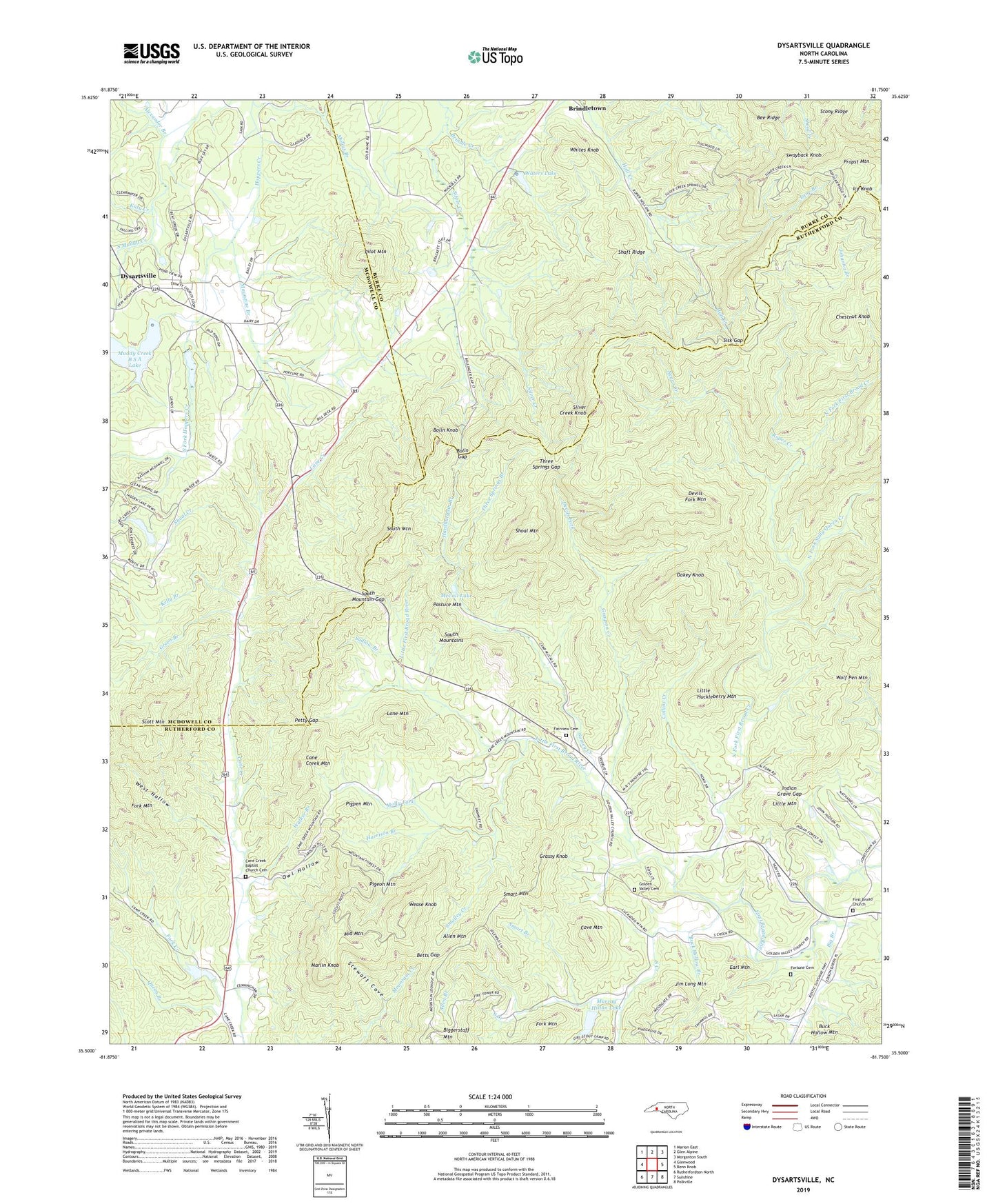
2022 topographic map quadrangle Dysartsville in the state of North Carolina. Scale: 1:24000. Based on the newly updated USGS 7.5' US Topo map series, this map is in the following counties: Rutherford, McDowell, Burke. The map contains contour data, water features, and other items you are used to seeing on USGS maps, but also has updated roads and other features. This is the next generation of topographic maps. Printed on high-quality waterproof paper with UV fade-resistant inks.
Quads adjacent to this one:
West: Glenwood
Northwest: Marion East
North: Glen Alpine
Northeast: Morganton South
East: Benn Knob
Southeast: Polkville
South: Sunshine
Southwest: Rutherfordton North
This map covers the same area as the classic USGS quad with code o35081e7.
Contains the following named places: Alexander Branch, Allen Branch, Allen Mountain, Bee Ridge, Betts Gap, Big Branch, Biggerstaff Mountain, Bolin Gap, Bolin Knob, Brindle Creek, Buck Hollow Branch, Cane Creek Baptist Church Cemetery, Cane Creek Church, Cane Creek Mountain, Chestnut Knob, Collins Creek, Cove Mountain, Cowan School, Devils Fork, Devils Fork Mountain, Dysartsville, Earl Mountain, Fairview Cemetery, Fairview Church, First Broad Church, Flood Control Dam Number 20, Fork Creek, Fork Mountain, Fortune Cemetery, Fortunes Store, Golden, Golden Church, Golden Valley Cemetery, Golden Valley Church, Grassy Knob, Grayson Creek, Green Branch, Hardburgain Branch, Harrison Branch, Icy Knob, Indian Grave Gap, Jim Long Mountain, Johanna Branch, Katy Creek, Kelly Branch, Lane Branch, Little First Broad River, Little Huckleberry Mountain, Little Mountain, Lone Mountain, Magazine Branch, Marlin Knob, McCall Lake, Middle Mountain, Missionary Church, Molly Fork, Mollys Branch, Mountain Home, Muddy Creek B S A Dam, Muddy Creek B S A Lake, Murray Hilton Lake, Murray Hilton Lake Dam, Negro Creek, North Fork First Broad Creek, North Fork Sally Queen Creek, Oakey Knob, Owl Hollow, Pasture Mountain, Petty Gap, Pigeon Mountain, Pigpen Mountain, Pilot Mountain, Propst Mountain, Queen Branch, Roper Creek, Scott Mountain, Shaft Ridge, Shoal Creek, Shoal Mountain, Silver, Silver Creek Church, Silver Creek Knob, Sisk Gap, Smalley Creek, Smart Branch, Smart Mountain, Somey Creek, South Creek, South Fork Hoppers Creek, South Mountain, South Mountain Gap, South Mountain Institute, Stewart Cove, Stony Ridge, Sudlow Branch, Swayback Knob, Three Springs Branch, Three Springs Gap, Township of Golden Valley, Walker Branch, Waters Lake, Waters Lake Dam, Wease Knob, West Hollow, Whites Knob, Wolf Pen Mountain