MyTopo
Robbinsville North Carolina US Topo Map
Couldn't load pickup availability
Also explore the Robbinsville Forest Service Topo of this same quad for updated USFS data
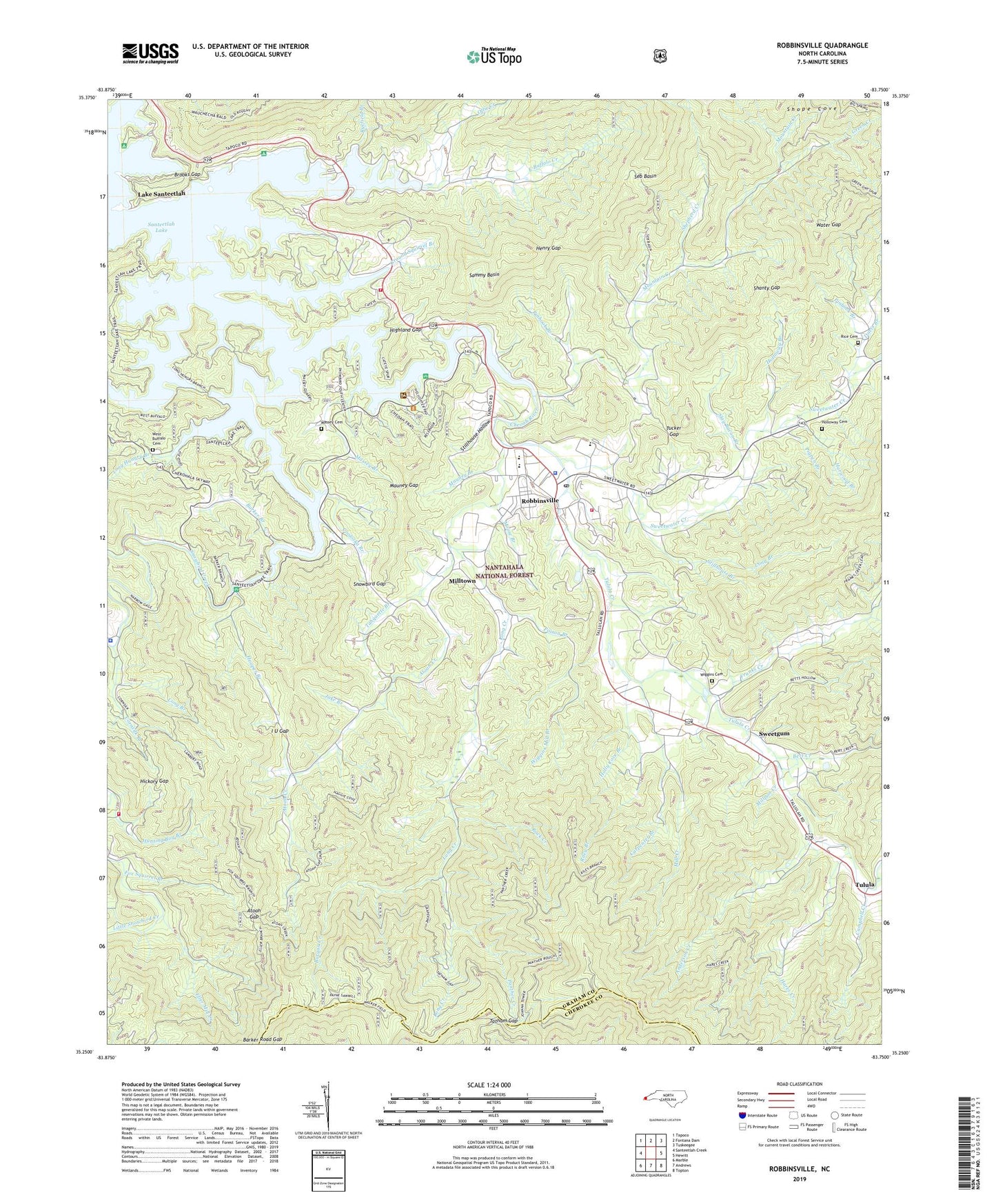
2022 topographic map quadrangle Robbinsville in the state of North Carolina. Scale: 1:24000. Based on the newly updated USGS 7.5' US Topo map series, this map is in the following counties: Graham, Cherokee. The map contains contour data, water features, and other items you are used to seeing on USGS maps, but also has updated roads and other features. This is the next generation of topographic maps. Printed on high-quality waterproof paper with UV fade-resistant inks.
Quads adjacent to this one:
West: Santeetlah Creek
Northwest: Tapoco
North: Fontana Dam
Northeast: Tuskeegee
East: Hewitt
Southeast: Topton
South: Andrews
Southwest: Marble
This map covers the same area as the classic USGS quad with code o35083c7.
Contains the following named places: 17 Land Tract, 28771, 373 Land Tract, 477 Land Tract, 588 Land Tract, 589 Land Tract, 91 Land Tract, 93 Land Tract, Anderson Creek, Atoah Church, Atoah Creek, Atoah Gap, Auntney Branch, Barker Branch, Barker Road Gap, Beech Creek, Bert Creek, Brooks Gap, Buffalo Church, Burgan Creek, Campbell Creek, Carpenter Branch, Ceoah Paint Campground, Cheoah Church, Cheoah Ranger District Office, Cherokee Police Department, Cooloska Branch, Cooper Knob, Cornsilk Branch, Davis Branch, Deep Gap, Deyton Camp, Dobson Hill, Eagle Knob, East Buffalo Church, East Buffalo Creek, Eller Cove, Eller Mill Creek, Fox Squirrel Branch, Franks Creek, Graham County, Graham County Emergency Medical Services, Graham County Fire Department Santeetlah Station 3, Graham County Rescue Squad, Graham County Sheriff's Office, Graham County Volunteer Fire Department Fort Hill Station, Green Creek, Green Gap, Ground Squirrel Branch, Hares Creek, Harwood Branch, Henry Gap, Hickory Gap, Highland Gap, Holloway Branch, Holloway Cemetery, Holly Cove Branch, Hooper Branch, Horse Range Ridge, Hunting Boy Branch, I U Gap, Jake Branch, Joanna Bald Fire Tower, John Teeseteska 367 404 405 Land Tract, Lake Santeetlah, Leonard Phillips Dam, Leonard Phillips Lake, Lone Oak Church, Long Branch, Long Creek, Long Creek Church, Long Hungry Branch, Massey Branch, Massey Cemetery, Mauney Branch, Mauney Gap, Mill Creek, Millpon Creek, Milltown, Moose Branch, Mountain Creek, Mountain Creek School, Ollie Creek, Panther Creek, Phillips Airport, Pigpen Branch, Pine Ridge Camp, Pinhook Branch, Pinnacle Knob, Poison Branch, Prince of Peace Catholic Church, Rice Cemetery, Riley Branch, Robbinsville, Robbinsville Elementary School, Robbinsville High School, Robbinsville Post Office, Rock Creek, Ryefield Branch, Sammy Basin, Santeetlah Lake, Seb Basin, Shanty Gap, Shepherd Creek, Shope Cove, Slay Bacon Branch, Snowbird Cherokee Indian School, Snowbird Community, Snowbird Creek, Snowbird Fire and Rescue, Snowbird Gap, Snowbird Mountains, Snowbird Picnic Area, Stillhouse Branch, Stillhouse Hollow, Sweetgum, Sweetwater Creek, Tahquette Branch, Tatham Gap, Teeseteska Ridge, Teyahalee Bald, The Hog Back, Town of Lake Santeetlah, Town of Robbinsville, Township of Cheoah, Tucker Gap, Tulula, Tulula Creek, Upper Cornsilk 374 Land Tract, Walker Field, Water Gap, West Buffalo Cemetery, West Buffalo Creek, Wiggins Cemetery, Wiggins Mill Branch, Zion Hill Church