MyTopo
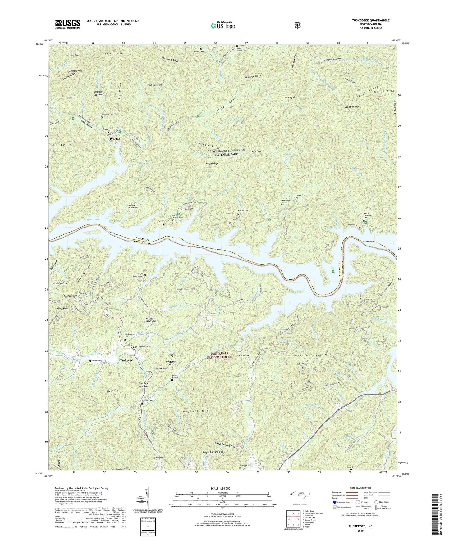
Tuskeegee North Carolina US Topo Map
Couldn't load pickup availability
Also explore the Tuskeegee Forest Service Topo of this same quad for updated USFS data
2023 topographic map quadrangle Tuskeegee in the state of North Carolina. Scale: 1:24000. Based on the newly updated USGS 7.5' US Topo map series, this map is in the following counties: Swain, Graham. The map contains contour data, water features, and other items you are used to seeing on USGS maps, but also has updated roads and other features. This is the next generation of topographic maps. Printed on high-quality waterproof paper with UV fade-resistant inks.
Quads adjacent to this one:
West: Fontana Dam
Northwest: Cades Cove
North: Thunderhead Mountain
Northeast: Silers Bald
East: Noland Creek
Southeast: Wesser
South: Hewitt
Southwest: Robbinsville
This map covers the same area as the classic USGS quad with code o35083d6.
Contains the following named places: Apple Tree Branch, Bailey Branch, Bearpen Branch, Bearpen Gap, Big Branch, Big Butte, Big Elk Knob, Big Fork Ridge, Big Ridge, Blankenship Cemetery, Bluff Branch, Boelinger Branch, Bone Valley Cemetery, Bone Valley Creek, Bradshaw Cemetery, Breedlove Cemetery, Briggs Garland Cove, Briggs Garland Gap, Brock, Brown Fork, Cable Branch, Cable Cemetery, Cable Cove, Cable Gap, Calhoun Branch, Chambers Creek, Chesquaw Branch, Chestnut Log Branch, Chestnut Log Gap, Cindy Branch, Clark Branch, Cody Branch, Cook-Mill Creek Cemetery, Coot Cove, Deep Gap, DeLozier Gap, Edwards Cemetery, Fairview Cemetery, Firescald Ridge, Fontana Lake, Garland Branch, Gunlock Ridge, Gunter Cemetery, Haw Gap Branch, Hickory Bottom, Hickory Bottom Branch, Hickory Cove, Higdon Cemetery, Hogback Mountain, Horseshoe Ridge, Hyde Branch, Indian Camp Branch, Johnson Cemetery, Johnson Gap, Johnson Gap Branch, Kirkland Branch, Laurel Branch, Licklog Gap, Little Branch, Little Elk Knob, Little Laurel Branch, Loudermilk Ridge, Lovin Entry Branch, Maggie Cable Cemetery, Maple Branch, Medlin Branch, Meetinghouse Branch, Meetinghouse Mountain, Mill Branch, Mitchel Cemetery, Nelms Family Cemetery, North Fork Tuskeegee Creek, Owensby Branch, Pendleton Creek, Perry Knob, Pikey Cemetery, Pilkey Creek, Pine Gap Branch, Pinnacle Ridge, Poison Cove Branch, Posey Cemetery, Possum Hollow, Powell Branch, Proctor, Proctor Branch, Proctor Cemetery, Pullback Ridge, Ramp Cove, Right Fork Cold Spring Branch, Roaring Branch, Rough Branch, Rowan Branch, Sandy Gap Branch, Sawyer Creek, Sawyer Creek Cemetery, Sawyer Creek Church, Shehan Branch, Snakeden Ridge, Soapstone Gap, South Fork Sawyer Creek, South Fork Tuskeegee Creek, Stecoah Creek, Sugar Fork, Taylor Branch, The Horseshoe, The Pinnacle, Tobacco Branch, Township of Stecoah, Tuskeegee, Tuskeegee Creek, Walker Gap, Walnut Hollow, Walnut Hollow Gap, Wasulu Ridge, Welch - Kirkland Cemetery, Welch Bald, White Pine Branch, Whiteside Creek, Whiteside Gap, Wildcat Gap, Williams Cove, Wolf Creek, Yellow Branch, Yellow Branch Cemetery