MyTopo
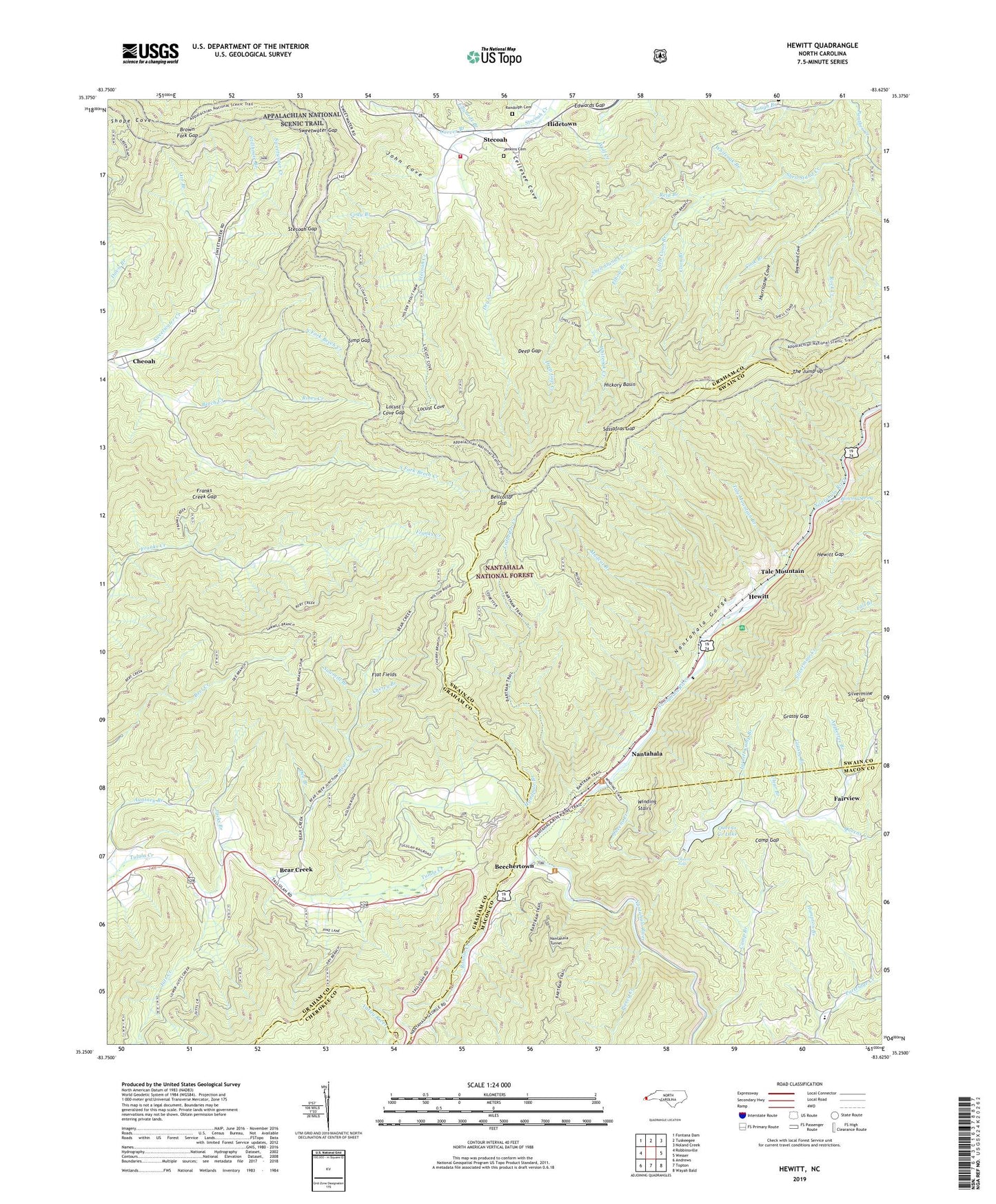
Hewitt North Carolina US Topo Map
Couldn't load pickup availability
Also explore the Hewitt Forest Service Topo of this same quad for updated USFS data
2022 topographic map quadrangle Hewitt in the state of North Carolina. Scale: 1:24000. Based on the newly updated USGS 7.5' US Topo map series, this map is in the following counties: Graham, Swain, Macon, Cherokee. The map contains contour data, water features, and other items you are used to seeing on USGS maps, but also has updated roads and other features. This is the next generation of topographic maps. Printed on high-quality waterproof paper with UV fade-resistant inks.
Quads adjacent to this one:
West: Robbinsville
Northwest: Fontana Dam
North: Tuskeegee
Northeast: Noland Creek
East: Wesser
Southeast: Wayah Bald
South: Topton
Southwest: Andrews
This map covers the same area as the classic USGS quad with code o35083c6.
Contains the following named places: Appletree Branch, Bear Creek, Beechertown, Bellcollar Gap, Bert Creek Lead, Blowing Spring, Briertown Mountain, Brown Fork Gap, Cabin Branch, Camp Branch, Camp Branch School, Camp Gap, Carver Branch, Cellesee Cove, Cheoah, Cheoah Bald, Cherry Branch, Clear Branch, Cody Branch, Cook Branch, Coon Branch, Dee Branch, Deep Gap, Deep Gap Creek, Deep Gap Mountain, Dogwood Cove, Dry Creek, Edwards Branch, Edwards Gap, Elbow Branch, Fairview, Ferebee Memorial Picnic Area, Flat Fields, Franks Creek Gap, Franks Creek Lead, Grassy Branch, Grassy Gap, Grassy Top, Hampton Branch, Handpole Branch, Hewitt, Hewitt Gap, Hewitt Quarry, Hickory Basin, Hidetown, Hurricane Cove, Jacks Branch, Jarrett Camp Branch, Jenkins Cemetery, John Cove, Juts Creek, Laurel Branch, Ledbetter Creek, Little Bald, Little Coon Branch, Locust Cove, Locust Cove Gap, Mudcut Branch, Nantahal River Launch Site, Nantahala, Nantahala Gorge Recreation Site, Nolton Ridge, North Fork Beech Creek, Orr Branch, Partridge Creek, Piercy Creek, Queens Creek, Queens Creek Dam, Queens Creek Lake, Queens Falls, Randolph Cemetery, Rattlesnake Knob, Reid Branch, Rines Creek, Rock Creek, Rowlin Creek, Rowlin School, Sassafras Gap, Sassafras Gap Recreation Site, Sawmill Branch, Shell Stand Creek, Silvermine Gap, Simp Gap, South Fork Beech Creek, Stecoah, Stecoah Gap, Stecoah Township Rescue Squad and Fire Department, Stecoah Union School, Stillhouse Branch, Sweetwater Gap, Swim Bald, Talc Mountain, Tale Mountain Branch, The Jump-up, Whiteoak Branch, Whiteoak Creek, Winding Stairs, Wykle Hill