MyTopo
Walkertown North Carolina US Topo Map
Couldn't load pickup availability
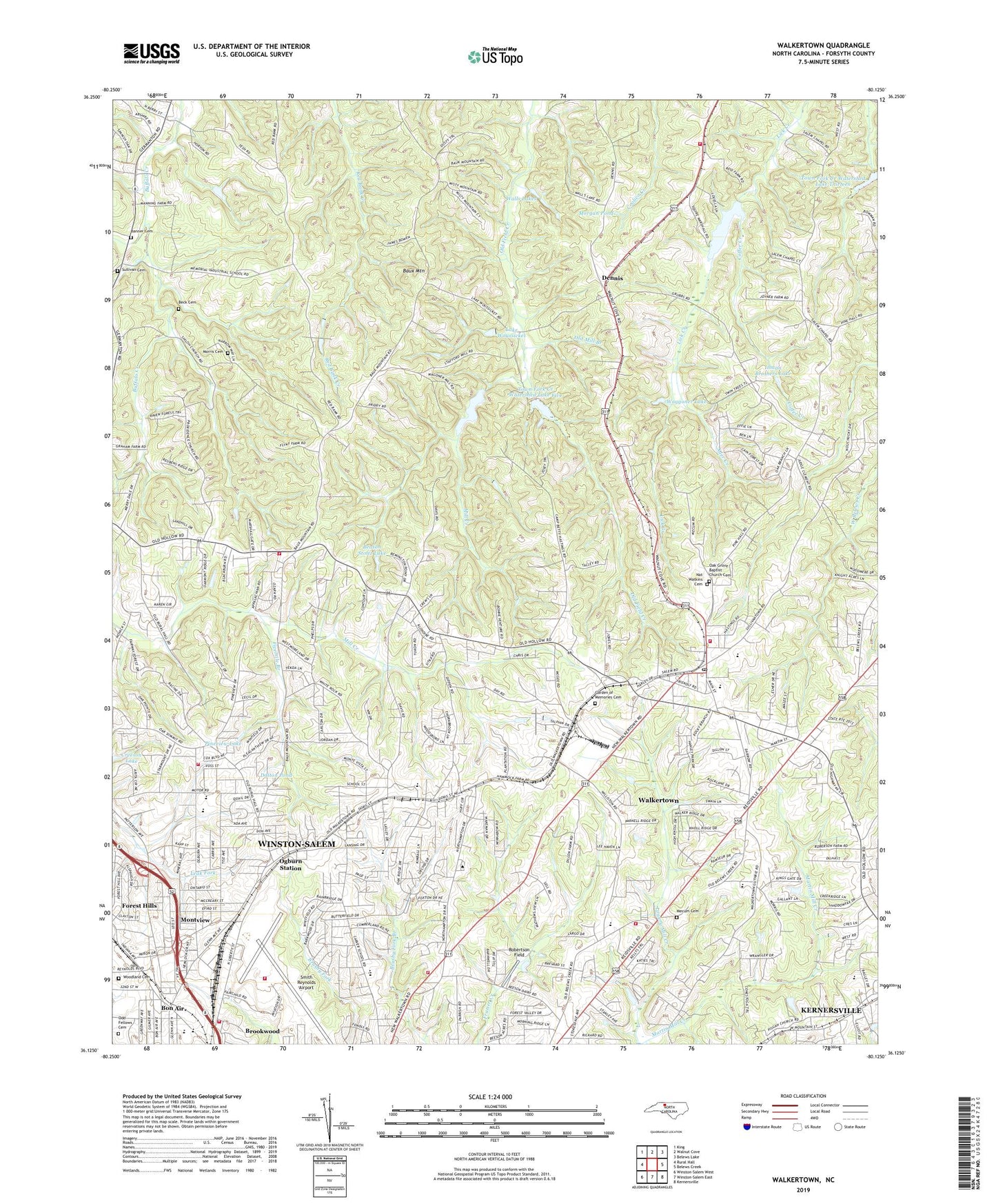
2022 topographic map quadrangle Walkertown in the state of North Carolina. Scale: 1:24000. Based on the newly updated USGS 7.5' US Topo map series, this map is in the following counties: Forsyth. The map contains contour data, water features, and other items you are used to seeing on USGS maps, but also has updated roads and other features. This is the next generation of topographic maps. Printed on high-quality waterproof paper with UV fade-resistant inks.
Quads adjacent to this one:
West: Rural Hall
Northwest: King
North: Walnut Cove
Northeast: Belews Lake
East: Belews Creek
Southeast: Kernersville
South: Winston-Salem East
Southwest: Winston-Salem West
This map covers the same area as the classic USGS quad with code o36080b2.
Contains the following named places: Ader Creek, Banner Cemetery, Baux Mountain, Baux Mountain Church, Beason Stoltz Dam, Beason Stoltz Lake, Beck Cemetery, Bethlehem Church, Blaylock Lake, Blaylock Lake Dam, Bon Air, Brookwood, Calvary Church, Camp Betty Hastings, Camp Civitan, Camp Lasater, Carver High School, Center Stage at Walkertown, Chalk Level, Chestnut Trails, City View Volunteer Fire Department, Coffer Creek, Creekwood Acres, Dalton Pond, Darla Don, Day Acres, Dennis, Dennis Church, Dilhast, Fivemile Branch, Forest Hills, Forsyth County Fire Department, Garden of Memories Cemetery, Gospel Light Chapel, Grubbs Lake, Grubbs Lake Dam, Hanes High School, Hatt Church, Inman Brothers Dam, Inman Brothers Lake, Jones Pond, Kansas Branch, Lake Woussicket, Lovell Lake, Lovell Lake Dam, Lowrance School, Macedonia Church, Marshall Church, Mecum Cemetery, Memorial Industrial School, Middle Fork Township, Mill Creek, Mineral Springs Church, Mineral Springs Elementary School, Mineral Springs Park, Mineral Springs Volunteer Fire Department and Rescue Squad Station 18, Montview, Morgan Pond, Morris Cemetery, Morris Chapel, Mount Olive Church, Mount Pleasant Church, Nat Watkins Cemetery, North Side Shopping Center, Oak Grove Baptist Church Cemetery, Oak Grove Church, Oak Summit School, Odd Fellows Cemetery, Ogburn Station, Old Hollow Estates, Old Mill Branch, Piedmont Park, Pineview Lake, Pleasant Hope Church, Providence Church, Red Bank Church, Robertson Field, Rough Fork, Salem Chapel Fire Department Station 24, Sedges Garden, Shiloh Church, Shouse Temple, Smith Reynolds Airport, Sullivan Cemetery, Town Creek Watershed Dam Number Thirteen, Town Fork Creek Watershed Dam Number Five, Town Fork Creek Watershed Dam Number Six, Town Fork Creek Watershed Dam Number Two, Town Fork Creek Watershed Lake Five, Town Fork Creek Watershed Lake Six, Town Fork Creek Watershed Lake Thirteen, Town Fork Creek Watershed Lake Two, Town of Walkertown, Township of Middle Fork I, Township of Middle Fork II, Township of Salem Chapel, Trick-Um Creek, Waggoner Lake, Walkertown, Walkertown Elementary School, Walkertown Fire Department Station 22, Walkertown Middle School, Walkertown Post Office, Walkertown Shopping Center, Walls Lakes, White Rock School, Winston - Salem Fire Department Liberty North Fire Station 3, Winston - Salem Fire Department Station 12, Winston - Salem Fire Department Station 9 Ogburn Avenue, Winston Salem Rescue Squad, Woodland Cemetery, ZIP Codes: 27051, 27105