MyTopo
Winston-Salem East North Carolina US Topo Map
Couldn't load pickup availability
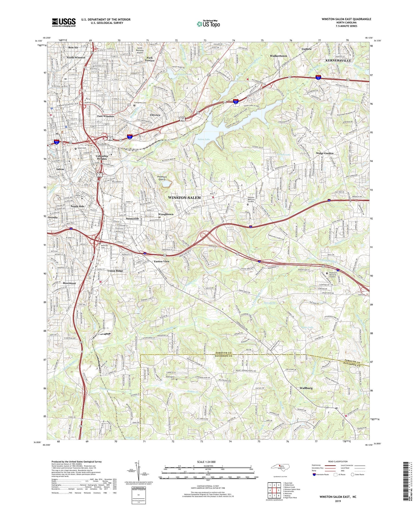
2022 topographic map quadrangle Winston-Salem East in the state of North Carolina. Scale: 1:24000. Based on the newly updated USGS 7.5' US Topo map series, this map is in the following counties: Forsyth, Davidson. The map contains contour data, water features, and other items you are used to seeing on USGS maps, but also has updated roads and other features. This is the next generation of topographic maps. Printed on high-quality waterproof paper with UV fade-resistant inks.
Quads adjacent to this one:
West: Winston-Salem West
Northwest: Rural Hall
North: Walkertown
Northeast: Belews Creek
East: Kernersville
Southeast: High Point West
South: Midway
Southwest: Welcome
This map covers the same area as the classic USGS quad with code o36080a2.
Contains the following named places: Arcadia, Ashley School, Atkins High School, Bellevue Cemetery, Benton Convention Center, Blevins Airport, Blum Park, Bowman-Gray Stadium, Boys School, Brushy Fork, Brushy Fork Branch, Brushy Fork School, Buck Branch, Center City Post Office, Central Park, Central Park Pool, Charleston, Cityview, Cityview School, Civitan Park, Columbia Heights, Crews Church, Dreamland Park School, East Forsyth High School, East Winston, East Winston Center, Eastok School, Easton View, Evergreen Cemetery, Fairview School, Fiddlers Creek, Fishers Branch, Forest Park, Forest Park Elementary School, Forsyth County Courthouse, Forsyth County Emergency Medical Services, Forsyth County Sheriff's Office, Forsyth Vocational High School, Four Seasons, Fourteenth Street Park, Fourteenth Street School, Frazier Creek, Friedland Church, Glen High Estates, Gray High School, Guthrie, Happy Hill Park, Hartman Branch, Hill School, Hines Lake, Hiram H Ward Federal Building, Holly Acres, Hopewell Church, John Vogler House, Kerners Mill Creek, Konnoak Elementary School, Lower Angel Lake, Lower Angel Lake Dam, Lowery Mill Creek, Martin Mill Creek, Merriweather Estates, Miksch Tobacco Shop, Morningside Manor, Mount Zion Church, Museum of Early Southern Decorative Arts, Myers Pond, New Friendship Baptist Church, New Mount Vernon Methodist Church, Nichols Lake, Nichols Lake Dam, North School, North Winston, Oak Grove Church, Oak Lawn Church, Oaklawn Memorial Gardens, Old Mount Vernon Church, Old Salem, Park Terrace, Parkview Shopping Center, Philo Middle School, Piedmont Memorial Gardens, Piedmont Quarry, Reynolds Memorial Hospital, Reynolds Park, Rolling Acres, Rosemont, Saint Delight Church, Salem, Salem Cemetery, Salem College, Salem Lake, Salem Lake Dam, Salem Tavern, Samaritan Baptist Church, Sawmill Branch, Sedge Garden, Sedge Garden School, Shalimar, Shultz Shoemaker Shop, Single Brothers House, Skyland Park, Skyland School, Skyview Park, Smith Creek, Soakas Creek, South Side, South Winston Station, Sprague Street Park, Sunnyside, Swaim Creek, Tar Branch, Township of Broadbay, Union Ridge, Vierling House, Wallburg, Wallburg Elementary School, Wallburg Fire Department, Wallburg Post Office, Wallburg School, Washington Cemetery, Washington Park, Waughtown, Waughtown Post Office, WBFJ-AM (Winston-Salem), Willowbend, Winkler Bakery, Winston - Salem Fire Department AB Bullard Fire Station 1, Winston - Salem Fire Department Lester E Ervin Fire Station 4, Winston - Salem Fire Department Palmer Lane South Fire Station 5, Winston - Salem Fire Department Parkview Fire Station 11, Winston - Salem Fire Department Station 17, Winston - Salem Police Department, Winston Lake, Winston Lake Dam, Winston Lake Golf Course, Winston Salem Post Office, Winston-Salem, Winston-Salem Air Force Station, Winston-Salem City Hall, Winston-Salem State University, Woodbridge, Woodland School, WSMX-AM (Winston-Salem), WSNC-FM (Winston-Salem), ZIP Codes: 27101, 27107, 27110