MyTopo
Tarboro North Carolina US Topo Map
Couldn't load pickup availability
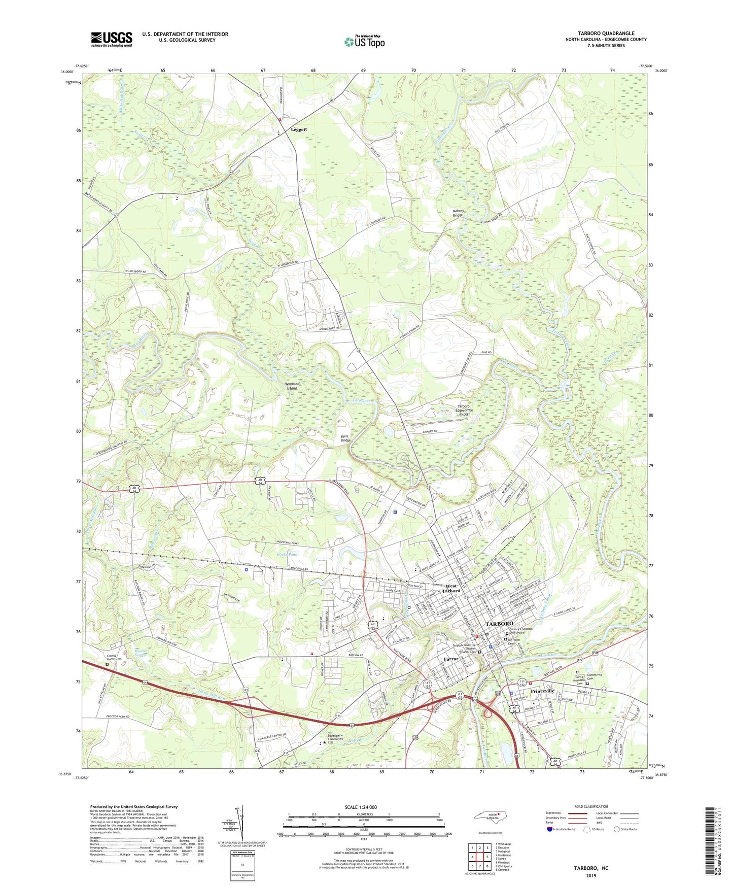
2022 topographic map quadrangle Tarboro in the state of North Carolina. Scale: 1:24000. Based on the newly updated USGS 7.5' US Topo map series, this map is in the following counties: Edgecombe. The map contains contour data, water features, and other items you are used to seeing on USGS maps, but also has updated roads and other features. This is the next generation of topographic maps. Printed on high-quality waterproof paper with UV fade-resistant inks.
Quads adjacent to this one:
West: Hartsease
Northwest: Whitakers
North: Draughn
Northeast: Hobgood
East: Speed
Southeast: Conetoe
South: Old Sparta
Southwest: Pinetops
This map covers the same area as the classic USGS quad with code o35077h5.
Contains the following named places: Alcohol Law Enforcement, Austin Pines, Bells Bridge, Belvedere, Brentwood, Bridger School, Burlington Park, Calvary Church, Calvary Episcopal Churchyard, Clifton Ridge, Coker-Wimberly School, Colonial Woods, Community Cemetery, County Home Cemetery, Cromwell Heights, Dancy Memorial Cemetery, Dancys Landing, Deans Heights, Deep Creek, East Tarboro Canal, Edgecombe County, Edgecombe County Courthouse, Edgecombe County Rescue Squad, Edgecombe County Sheriff's Office, Edgecombe Criminal Division, Edgecombe Hills, Edgecombe Technical Institute, Fairview, Farrar, Fishing Creek, Forest Acres, Glenburnie, Grace Church, Greenwood Cemetery, Harts Mill Run, Hatcher Swamp, Hemmed Island, Hendricks Creek, Hilma Park, Holly Creek, Hope Lodge, Leggett, Leggett Canal, Leggett Volunteer Fire Department, Logsboro, Lyndale Acres, Mabrey Bridge, Maple Springs Church, Maple Swamp, Martin Middle School, McNair Crossing, Mobile Home Estates, North Carolina State Highway Patrol Troop C District 1 Substation, North Edgecombe High School, North Tarboro School, Old Salem Church, Old Town Cemetery, Panola Heights, Parkhill Mall, Pattillo Elementary School, Penders Chapel, Penders Mill Run, Pine Ridge, Princeville, Princeville Elementary School, Princeville Police Department, Princeville Town Hall, Princeville Volunteer Fire Department, Raccoon Branch, Runnymeade, Saint James Church, Southern Terrace, Speight Forest, Stafford Forest, Stoney Point Elementary School, Summerfield, Sunrise Park, Sunset Estates, Swift Creek, Tarboro, Tarboro Edgecombe Academy, Tarboro Fire Department Station 1, Tarboro Fire Department Station 2, Tarboro High School, Tarboro Police Department, Tarboro Post Office, Tarboro Primitive Baptist Church Cemetery, Tarboro Town Hall, Tarboro-Edgecombe Airport, Teller High School, Town of Leggett, Town of Princeville, Town of Tarboro, Township 1-Tarboro, Vidant Edgecomb Hospital, WCPS-AM (Tarboro), Weeks Pond, Weeks Pond Dam, West Hills, West Tarboro, White Oak Swamp, WKTC-FM (Tarboro), Woodgreen, ZIP Code: 27886