MyTopo
Wahpeton North Dakota US Topo Map
Couldn't load pickup availability
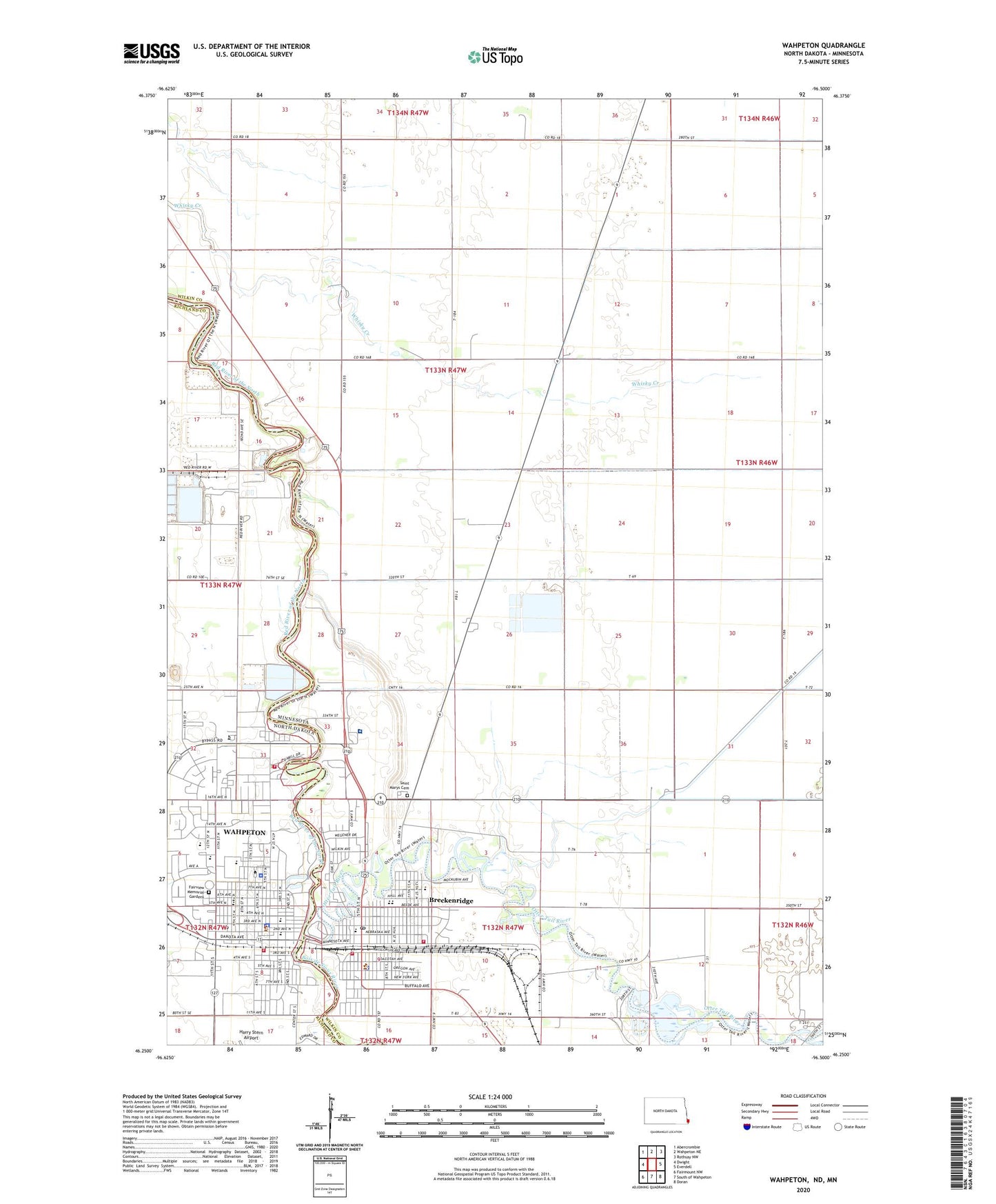
2024 topographic map quadrangle Wahpeton in the states of Minnesota, North Dakota. Scale: 1:24000. Based on the newly updated USGS 7.5' US Topo map series, this map is in the following counties: Richland, Wilkin. The map contains contour data, water features, and other items you are used to seeing on USGS maps, but also has updated roads and other features. This is the next generation of topographic maps. Printed on high-quality waterproof paper with UV fade-resistant inks.
Quads adjacent to this one:
West: Dwight
Northwest: Abercrombie
North: Wahpeton NE
Northeast: Rothsay NW
East: Everdell
Southeast: Doran
South: South of Wahpeton
Southwest: Fairmount NW
This map covers the same area as the classic USGS quad with code o46096c5.
Contains the following named places: Ambulance Service, Babcock Residence Hall, Ballweber Hall, Barnard Hall, Bisek Hall, Bois de Sioux Country Club, Bois de Sioux River, Boise De Sioux Mobile Estates, Breckenridge, Breckenridge Elementary and Middle School, Breckenridge Fire Department Station 1, Breckenridge Fire Department Station 2, Breckenridge High School, Breckenridge Historical Marker, Breckenridge Lake, Breckenridge Lake Dam, Breckenridge Lutheran Church, Breckenridge Police Department, Breckenridge Post Office, Breckenridge Public Library, Building Construction Technology Building, Burch Hall, Central Elementary School, Chahinkapa Park, Chahinkapa Zoo, Circle of Nations School, City of Breckenridge, City of Wahpeton, Clair T Blikre Activities Center, County Ditch Number Twentyeight, Earl Skip Bute Alumni Stadium, Ed Werre Arena, Fairview Memorial Gardens, Faith Evangelical Free Church, First Baptist Church, Forkner Residence Hall, Frank Vertin Athletic Field, Friendship Sculpture Monument, Gayle Miller Softball Complex, Gewalt Park, Grace Lutheran Church, Harry Stern Airport, Haverty Hall, Headwaters Park, Hektner Hall, Henry Stern and Ella Stern Cultural Center, Horton Hall, Inspiration Lutheran Brethren Church, Jefferson Park, KBMW-AM (Breckenridge) (Wahpet), Kids Korner Playground, Kindom Hall of Jehovahs Witnesses, Leach Public Library, Lions Park, Main Street Rotary Park, Mayme Green Allied Health Center, McMahon Hall, Mechanical Systems Building, Mildred Johnson Library, Nordgaard Residence Hall, North Dakota State College of Science, North Dakota State College of Science Police Department, North Dakota State College of Science Student Center, Northwest College Complex Apartments, Old Main Building, Otter Tail River, Ox Cart Trail Park, Patterson Maintenance Center, Railroad Park, Richards School, Richland County Courthouse, Richland County Historical Museum, Richland County Jail, Richland County Sheriff's Office, Riley Residence Hall, Robertson Residence Hall, Saint Catherines Living Center, Saint Francis Healthcare Hospital, Saint Francis Home, Saint Johns Elementary School, Saint Mary's Catholic Church, Saint Marys Cemetery, Saint Mary's School, Satterlee Hall, Schuett Hall, Schulz Residence Hall, Southeast College Complex Apartments, Technical Center, Thirty-Six College Complex Apartments, Township of Connelly, Trade Technology II Building, United Methodist Church, Valley Christian Assembly Church, Wahpeton, Wahpeton City Hall, Wahpeton Fire Department Main Station, Wahpeton Fire Department Northside Station, Wahpeton High School, Wahpeton Middle School, Wahpeton Police Department, Wahpeton Post Office, Walton Residence Hall, Welles Park, Wilkin County Courthouse, Wilkin County Historical Society Library, Wilkin County Jail, Wilkin County Museum, Wilkin County Sheriff's Office, Zimmerman Elementary School, ZIP Code: 58076