MyTopo
Carrollton Ohio US Topo Map
Couldn't load pickup availability
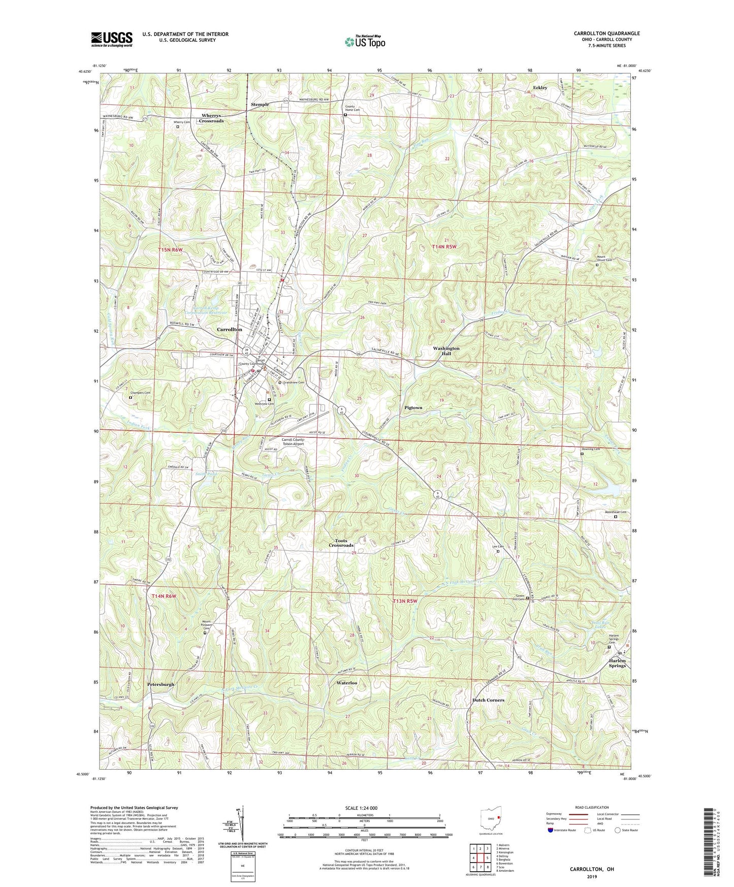
2023 topographic map quadrangle Carrollton in the state of Ohio. Scale: 1:24000. Based on the newly updated USGS 7.5' US Topo map series, this map is in the following counties: Carroll. The map contains contour data, water features, and other items you are used to seeing on USGS maps, but also has updated roads and other features. This is the next generation of topographic maps. Printed on high-quality waterproof paper with UV fade-resistant inks.
Quads adjacent to this one:
West: Dellroy
Northwest: Malvern
North: Minerva
Northeast: Kensington
East: Bergholz
Southeast: Amsterdam
South: Scio
Southwest: Bowerston
This map covers the same area as the classic USGS quad with code o40081e1.
Contains the following named places: Algonquin Mill, Becki Lynn Court, Bell-Heron Middle School, Carroll County, Carroll County Courthouse, Carroll County Home, Carroll County Sheriff's Office, Carroll County Volunteer Fire Department, Carroll County-Tolson Airport, Carroll Hills School, Carroll Hills Training Center, Carroll Kemp Corporation Dam, Carroll Kemp Corporation Reservoir, Carroll View Terrace, Carrollton, Carrollton Elementary School, Carrollton High School, Carrollton Post Office, Carrollton Village Fire Department, Champers Cemetery, Chestnut Grove School, County Home Cemetery, Downing Cemetery, Dutch Corners, Eckley, Eckley Post Office, Emergency Medical Transport Carrollton Station 3, EMT Ambulance, Fawcett School, Friday Creek, Gantz Creek, Grandview Cemetery, Green Hill Cemetery, Harlem Springs, Harlem Springs Cemetery, Harlem Springs Elementary School, Harlem Springs Post Office, Heritage Hills, Hickory Grove, Hills Trailer Court, Honey Run, Lee Cemetery, Minor's Mobile Home Park, Moorehead Cemetery, Mount Olivet Cemetery, Mount Olivet Church, Mount Pleasant Cemetery, Mount Pleasant Church, Mud School, Our Lady of Fatima School, Petersburgh, Pigtown, Pleasant Hill Church, Puskarich Brothers Lake, Puskarich Brothers Lake Dam, Puskarich Limestone Quarry, Rolling Meadow Acres, Roudebush School, Smith Pond, Smith Pond Dam, Smith School, Stemple, Toot School, Toots Crossroads, Town Creek, Township of Center, Township of Union, Township of Washington, Trail Run Lakes, Trail Run Lakes Dam, Village of Carrollton, Washington Hall, Washington Hall School, Waterloo, Waterworks Park, Westview Cemetery, Wherry Cemetery, Wherrys Crossroads, Wyncrest, ZIP Code: 44615