MyTopo
Clifton Ohio US Topo Map
Couldn't load pickup availability
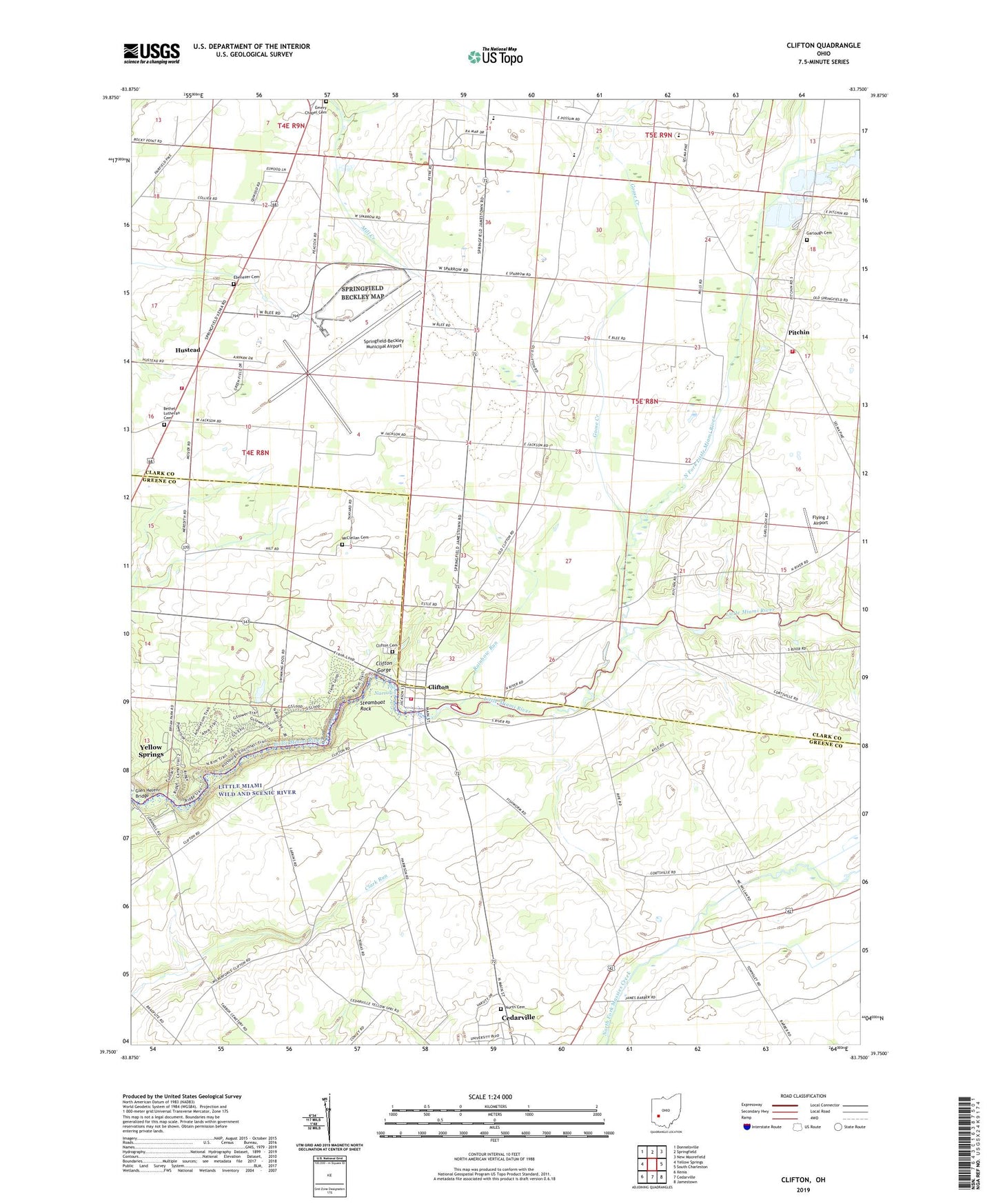
2023 topographic map quadrangle Clifton in the state of Ohio. Scale: 1:24000. Based on the newly updated USGS 7.5' US Topo map series, this map is in the following counties: Clark, Greene. The map contains contour data, water features, and other items you are used to seeing on USGS maps, but also has updated roads and other features. This is the next generation of topographic maps. Printed on high-quality waterproof paper with UV fade-resistant inks.
Quads adjacent to this one:
West: Yellow Springs
Northwest: Donnelsville
North: Springfield
Northeast: New Moorefield
East: South Charleston
Southeast: Jamestown
South: Cedarville
Southwest: Xenia
This map covers the same area as the classic USGS quad with code o39083g7.
Contains the following named places: Arboretum Trail, Bethel Church, Bethel Lutheran Cemetery, Blue Hole, Calvary Church, Camp Birch, Camp Clifton, Camp Cooper, Camp Greene, Cemetery, Clifton, Clifton Cemetery, Clifton Gorge, Clifton Gorge State Nature Preserve, Clifton Mill, Clifton Post Office, Clifton United Presbyterian Church, Crawley Field, Ebenezer Cemetery, Emery Chapel United Methodist Church, Flying J Airport, Garlough Cemetery, Goose Creek, Green Special School, Grinnell Mill Historic District, Horace Mann Memorial Monument, Hustead, Hustead Emergency Services, Hustead Post Office, John Bryan State Park, Lower Picnic Area, McClellan Cemetery, Miami Township Fire and Rescue Station 2, North Fork Little Miami River, Orton Memorial Monument, Orton Memorial Trail, Orton Picnic Area, Peacock Acres, Peifer Orchards, Pitchin, Pitchin Post Office, Pitchin Village Fire Department, Rainbow Run, Shawnee High School, South Gorge Trail, Springfield-Beckley Air Guard Station, Springfield-Beckley Municipal Airport, Steamboat Rock, The Narrows, Township of Green, Township of Miami, Village of Clifton, Wingo Picnic Area, Youngs Jersey Dairy, ZIP Codes: 45314, 45316, 45502