MyTopo
Medina Ohio US Topo Map
Couldn't load pickup availability
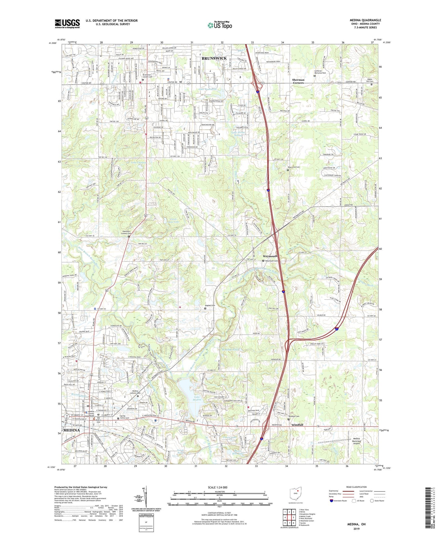
2023 topographic map quadrangle Medina in the state of Ohio. Scale: 1:24000. Based on the newly updated USGS 7.5' US Topo map series, this map is in the following counties: Medina. The map contains contour data, water features, and other items you are used to seeing on USGS maps, but also has updated roads and other features. This is the next generation of topographic maps. Printed on high-quality waterproof paper with UV fade-resistant inks.
Quads adjacent to this one:
West: Mallet Creek
Northwest: West View
North: Berea
Northeast: Broadview Heights
East: West Richfield
Southeast: Wadsworth
South: Seville
Southwest: Westfield Center
This map covers the same area as the classic USGS quad with code o41081b7.
Contains the following named places: Academy Farms, Ames Plaza Shopping Center, Applewood Elementary School, Archway Plaza Shopping Center, Bagdad Cemetery, Bradway Creek, Brunswick, Brunswick Branch Medina County District Library, Brunswick Center Cemetery, Brunswick Division of Fire Station 1, Brunswick Division of Police, Brunswick High School, Brunswick Hills Fire and Rescue Station 1, Brunswick Hills Golf Course, Brunswick Plaza Shopping Center, Brunswick Post Office, Bunker Hill Golf Course, C R Towslee Elementary School, Carlson Ambulance Transport Service, Carol-Jane Lake, Carol-Jane Lake Dam, Champion Creek, Church of God, Church of God in Christ, City of Brunswick, City of Medina, Crestwood Park, Edwards Middle School, Ella Canavan Elementary School, First Baptist Church, First Christian Church, Forest Lake, Forest Lake Dam, Friendship Baptist Church, Garfield Elementary School, Goodyear Creek, Grace Church, Gravel Creek, Hadcock Center Shopping Center, Hamilton Corners Cemetery, Hickory Ridge Elementary School, Hillside Orchard, Huntington Elementary School, Lake Brunswick, Lake Brunswick Dam, Lake Chateau, Lake Chateau Dam, Lake Medina, Lake Medina Dam, Lake Sleepy Hollow, Laurel Square Shopping Center, Lifecare Medical Services Medina Substation, Lutheran Memorial Park, Maple Hill Cemetery, Medina, Medina Catholic Cemetery, Medina Christmas Tree Farm, Medina City Hall, Medina Claggett Junior High School, Medina County Courthouse, Medina County District Library, Medina County Law Library, Medina Fire Department - Station 1, Medina High School, Medina Hospital, Medina Municipal Airport, Medina Police Department, Medina Post Office, Medina Public Square Historic District, Medina Shopping Center, Medina Township Fire Department - Station 1, Medina Township Fire Department - Station 2, Medina Township Police Department, Memorial Park, Miranda Pond, Miranda Pond Dam, Mount Pleasant Church, North Branch West Branch Rocky River, North Court Plaza Shopping Center, Ohio State Highway Patrol - Medina Patrol Post 52, Old Medina Cemetery, Orchard Path Creek, Plaza 71 Shopping Center, Pleasant Valley Golf Course, Plum Creek, Pythian Sisters Home, Ray Mellert Park, Reagan Park, Roscoe Ewing Park, Rustic Hills Lake, Rustic Hills Lake Dam, Saint Francis Xavier Roman Catholic Church, Saint Marks Church, Saint Matthew Evangelical Lutheran Church, Saint Pauls Episcopal Church, Saint Xavier School, Second Baptist Church, Sherman Corners, Sidney Fenn Elementary School, Skyland Golf Course, Spring Grove Cemetery, Torok Pond, Torok Pond Dam, Town Line Cemetery, Township of Brunswick Hills, Township of Medina, Township of Medina City, Victorian Village Shopping Center, Weymouth, Weymouth Cemetery, Willetts Addition Comprehensive School, Willetts Middle School, Windfall, Windfall Cemetery, Winding Trail Lake, Winding Trail Lake Dam, WRMR-AM (Cleveland), ZIP Codes: 44212, 44256