
MyTopo
Salem Ohio US Topo Map
Couldn't load pickup availability
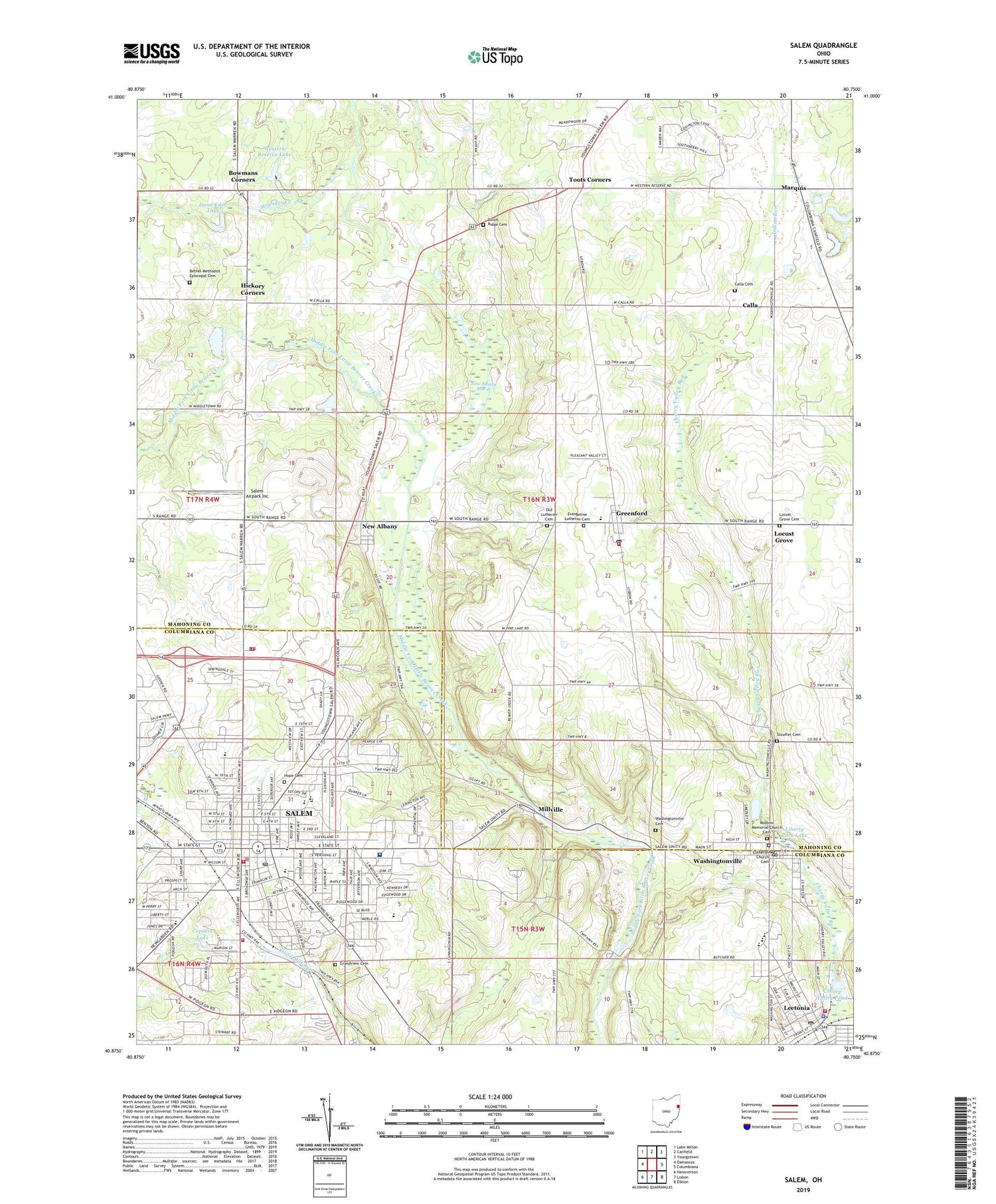
2019 topographic map quadrangle Salem in the state of Ohio. Scale: 1:24000. Based on the newly updated USGS 7.5' US Topo map series, this map is in the following counties: Mahoning, Columbiana. The map contains contour data, water features, and other items you are used to seeing on USGS maps, but also has updated roads and other features. This is the next generation of topographic maps. Printed on high-quality waterproof paper with UV fade-resistant inks.
Quads adjacent to this one:
West: Damascus
Northwest: Lake Milton
North: Canfield
Northeast: Youngstown
East: Columbiana
Southeast: Elkton
South: Lisbon
Southwest: Hanoverton
Contains the following named places: Allegheny Wesleyan Methodist Church, Believers Christian Fellowship Church, Bethel Methodist Episcopal Cemetery, Bowmans Corners, Buckeye Elementary School, Calla, Calla Cemetery, Callahan Ditch, Centennial Park, Cherry Valley Pond, City of Salem, Concord Church, Copacia Lake, Dunn Eden Lake, Dutch Ridge Cemetery, Eastgate Plaza Shopping Center, Emmanuel Lutheran Church, Evangeline Lutheran Cemetery, First Baptist Church, First Christian Church, First Friends Church, First Presbyterian Church, First Presbyterian Church of Leetonia, First United Methodist Church, First United Methodist Church of Leetonia, Fourth Street School, Goodman Ditch, Grandview Cemetery, Green Township Volunteer Fire Department, Greenford, Greenford Post Office, Greenford Station, Hickory Corners, Holy Trinity Lutheran Church, Hope Cemetery, Huffman Fruit Farm, K L G Mobile Intensive Company, Kelley Park, Knaufville, Knaufville Post Office, Leetonia, Leetonia Fire Department, Leetonia High School, Leetonia Police Department, Leetonia Post Office, Less And Less Orchards, Liberty Park Lake, Locust Grove, Locust Grove Cemetery, Lutheran Church Cemetery, Marquis, McKinley School, Millville, New Albany, New Albany Marsh, New Albany Post Office, Norkus Orchard, Old Lutheran Cemetery, Orchard Hill Elementary School, Perry Township Police, Perry Township Volunteer Fire Department North Station, Perry Township Volunteer Fire Department South Station, Prospect Elementary School, Reilly Elementary School, Robbins Memorial Church, Robbins Memorial Church Cemetery, Saint Patricks Catholic Church, Saint Paul Catholic Church, Saint Pauls School, Salem, Salem Airpark Inc, Salem Church, Salem Church of the Nazarene, Salem City Hall, Salem City Police Department, Salem Community Hospital Heliport, Salem Fire Department, Salem High School, Salem Middle School, Salem Mobile Home Park, Salem Plaza Shopping Center, Salem Post Office, Salem Public Library, Salem Regional Medical Center, Sells Crossing, South Range West Intermediate School, Southeast Elementary School, Southeast Friends Church, Stouffer Cemetery, Toots Corners, Township of Green, Township of Perry, Township Park, Twin Pines Apostolic Church, Village of Leetonia, Village of Washingtonville, Washington Post Office, Washingtonville, Washingtonville Cemetery, Washingtonville Elementary School, Washingtonville Post Office, Waterworth Memorial Park, Western Reserve Lake, White House Fruit Farm, WQXK-FM (Salem), ZIP Codes: 44460, 44490


