MyTopo
Duncan North Oklahoma US Topo Map
Couldn't load pickup availability
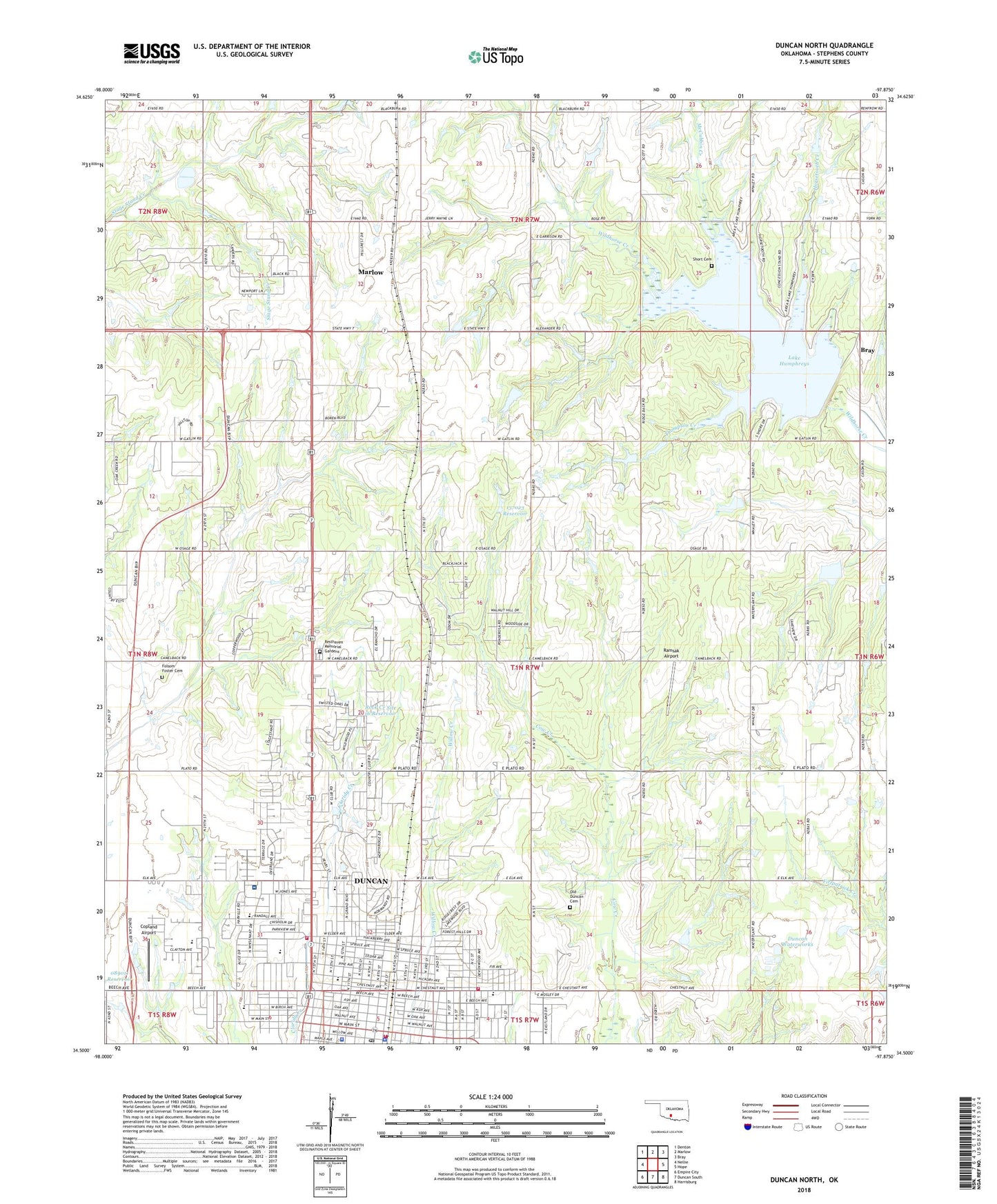
2022 topographic map quadrangle Duncan North in the state of Oklahoma. Scale: 1:24000. Based on the newly updated USGS 7.5' US Topo map series, this map is in the following counties: Stephens. The map contains contour data, water features, and other items you are used to seeing on USGS maps, but also has updated roads and other features. This is the next generation of topographic maps. Printed on high-quality waterproof paper with UV fade-resistant inks.
Quads adjacent to this one:
West: Nellie
Northwest: Denton
North: Marlow
Northeast: Bray
East: Hope
Southeast: Harrisburg
South: Duncan South
Southwest: Empire City
This map covers the same area as the classic USGS quad with code o34097e8.
Contains the following named places: All Saints Episcopal Church, American Medical Response Duncan / Marlow, Assumption Catholic Church, Bethel Assembly of God, Bible Church, Camp Winkler, Chisholm Trail Church - Christ, Christian Center, Christian School, Church of God, City of Duncan, Copland Airport, Cotton Hills Christian Church, Cumberland Church, Duncan, Duncan Division, Duncan Fire Department Headquarters, Duncan Fire Department Station 2, Duncan Fire Department Station 3, Duncan High School, Duncan Middle School, Duncan Police Department, Duncan Post Office, Duncan Regional Hospital, Duncan Regional Hospital Heliport, Duncan Waterworks, East Side Church, Eastside Church of Christ, Emerson Elementary School, Emerson School, First Assembly of God Church, First Baptist Church, First Christian Church, First Free Will Baptist Church, First Methodist Church, First United Methodist Church, Folsom Foster Cemetery, Fuqua Park, Gatlin School, Glad Tiding Church, Glorious Church Fellowship, Harvest Hills Baptist Church, Hillcrest Park, Horace Mann Elementary School, Horsetooth Creek, Immanuel Baptist Church, KRHD-AM (Duncan), KRHD-FM (Duncan), Lake Humphreys, Lee School, Lutheran Church Good Shepherd, Mark Twain Elementary School, Marlow, McCasland Rotary Park, McCasland Shopping Center, McCubbin Creek, Memorial Park, Mighty Mite Park, Number 2 Whisenant Shopping Center, Number Two Whisenant Shopping Center, Oak Avenue Church-The Nazarene, Oknoname 089011 Reservoir, Oknoname 137022 Dam, Oknoname 137022 Reservoir, Oknoname 137023 Dam, Oknoname 137023 Reservoir, Oknoname 137027 Dam, Oknoname 137027 Reservoir, Oknoname 137028 Dam, Oknoname 137028 Reservoir, Oknoname 137029 Dam, Oknoname 137029 Reservoir, Old Duncan Cemetery, Open Door Fellowship, Parkview Baptist Church, Plato Elementary School, Ramsak Airport, Resthaven Memorial Gardens, Rock Creek Site 13 Dam, Rock Creek Site 13 Reservoir, Rock Creek Site 16 Dam, Rock Creek Site 16 Reservoir, Saint Pauls United Methodist Church, Saint York Church, Short Cemetery, Stephens County Jail, Stephens County Sheriff's Office, The Church of Jesus Christ of Latter Day Saints, Thompson Creek, Township of Wall, Trinity Baptist Church, Union Center Church, Unity Church, Ward Mall, Wesley United Methodist Church, West Side Christian Church, Western Heights Baptist Church, Wildhorse Creek Site 20 Dam, Wildhorse Creek Site 20 Reservoir, Wildhorse Creek Site 21 Dam, Wildhorse Creek Site 21 Reservoir, Wildhorse Creek Site 22 Dam, Wildhorse Creek Site 22 Reservoir, Will Rogers Pre - K Center, Wisenant Park, Woodlawn School, Woodrow Wilson Elementary School