MyTopo
Gold Hill Oregon US Topo Map
Couldn't load pickup availability
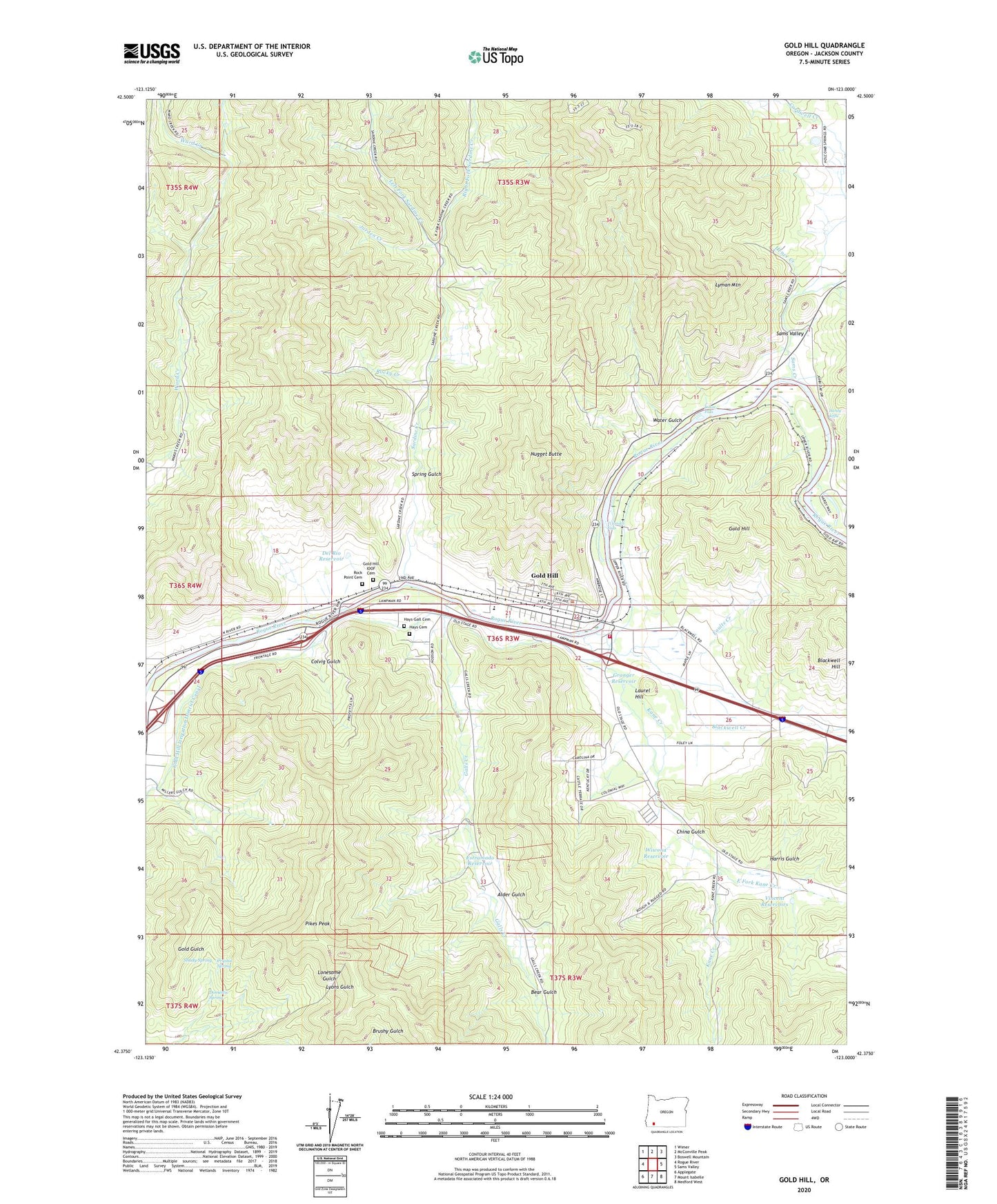
2023 topographic map quadrangle Gold Hill in the state of Oregon. Scale: 1:24000. Based on the newly updated USGS 7.5' US Topo map series, this map is in the following counties: Jackson. The map contains contour data, water features, and other items you are used to seeing on USGS maps, but also has updated roads and other features. This is the next generation of topographic maps. Printed on high-quality waterproof paper with UV fade-resistant inks.
Quads adjacent to this one:
West: Rogue River
Northwest: Wimer
North: McConville Peak
Northeast: Boswell Mountain
East: Sams Valley
Southeast: Medford West
South: Mount Isabelle
Southwest: Applegate
This map covers the same area as the classic USGS quad with code o42123d1.
Contains the following named places: Alder Gulch, Anderson Mine, Bear Gulch, Ben Hur Lampman State Park, Bill Nye Mine, Blackwell Creek, Blackwell Hill, Braden Mine, Cardwell Creek, Cemetery, China Gulch, City of Gold Hill, Colvig Gulch, Crystal Spring, Dardanelles, Dardanelles Post Office, Del Rio Reservoir, Del Rio Vineyards Non - Motorized Jackson County Boat Ramp, Dillon Falls, Domestic Spring, Dowden Falls Non - Motorized Boat Ramp, East Fork Kane Creek, Estramado Reservoir, Faults Creek, Fishers Ferry County Park, Galls Creek, Gold Hill, Gold Hill Beach Park Non - Motorized Boat Ramp, Gold Hill Chavner Water Treatment Plant, Gold Hill City Hall, Gold Hill Historical Society Museum, Gold Hill IOOF Cemetery, Gold Hill Irrigation District Canal, Gold Hill Library, Gold Hill Municipal Court, Gold Hill Post Office, Gold Hill Regional Park, Gold Hill Regional Park Non - Motorized Boat Ramp, Gold Hill Sewage Treatment Plant, Gold Nugget County Recreation Area, Gold Nugget Recreation Area Non - Motorized Boat Ramp, Granger Reservoir, Hanby Middle School, Hardy Riffle, Hardy Riffle County Park, Hardy Riffle Jackson County Park Boat Ramp, Harris Gulch, Hays Cemetery, Hays-Gall Cemetery, Hence Creek, Jackson County Fire District 3 Gold Hill Station, Jorden Creek, Kane Creek, Kell Mine, KRWQ-FM, Laurel Hill, Left Fork Sardine Creek, Little Giant Mine, Lyman Mine, Lyman Mountain, Magerly Reservoir, Molly Mine, Nugget Butte, Patrick Elementary School, Pikes Peak, Right Fork Sardine Creek, Rock Creek, Rock Point, Rock Point Cemetery, Rock Point Post Office, Rocky Creek, Sams Creek, Sams Valley, Sardine Creek, Sardine Creek Non-Motorized Boat Ramp, Shady Spring, Spring Gulch, Sylvanite Mine, Ti'lomikh Falls, Tinpan Mine, Van Der Hellen Gravel Pit, Vincent Reservoirs, Water Gulch, Wiwona Reservoir, Zacher, ZIP Code: 97525