MyTopo
Medford West Oregon US Topo Map
Couldn't load pickup availability
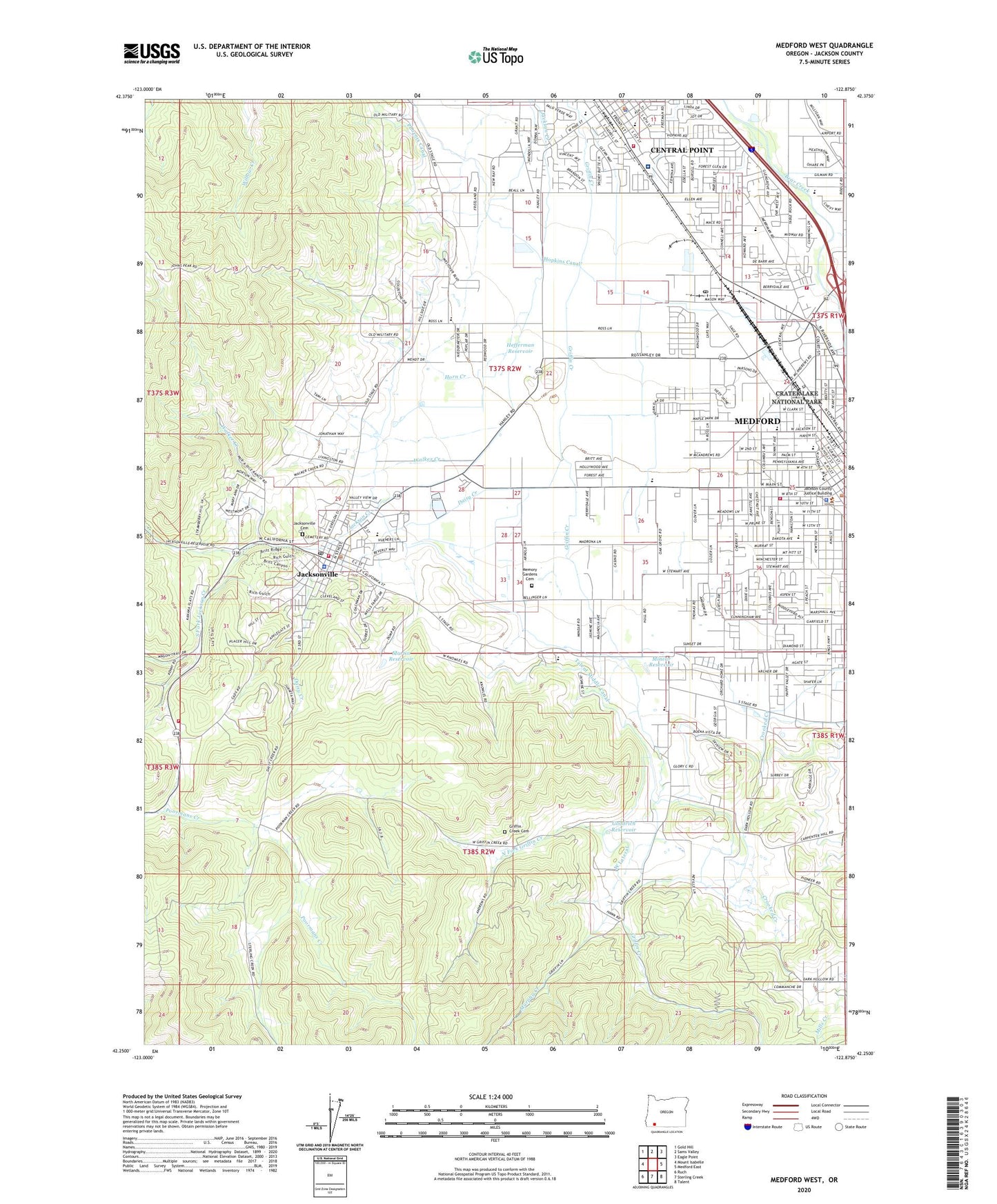
2023 topographic map quadrangle Medford West in the state of Oregon. Scale: 1:24000. Based on the newly updated USGS 7.5' US Topo map series, this map is in the following counties: Jackson. The map contains contour data, water features, and other items you are used to seeing on USGS maps, but also has updated roads and other features. This is the next generation of topographic maps. Printed on high-quality waterproof paper with UV fade-resistant inks.
Quads adjacent to this one:
West: Mount Isabelle
Northwest: Gold Hill
North: Sams Valley
Northeast: Eagle Point
East: Medford East
Southeast: Talent
South: Sterling Creek
Southwest: Ruch
This map covers the same area as the classic USGS quad with code o42122c8.
Contains the following named places: Applegate Valley Rural Fire Protection District Station 5, Bellinger Hill, Boise 1 and 2 Biomass Facility, Britt Festival Pavilion Stage, Britt Garden County Park, Bybee Corner, Cascade Christian High School, Central Point City Hall, Central Point Elementary School, Central Point Library, Central Point Municipal Court, Central Point Police Department, Central Point Public Works Department, City of Jacksonville, Crater Lake Junction, Daisy Creek, Dark Hollow, Goodrich Reservoir, Griffin Creek Cemetery, Griffin Creek Elementary School, Hanley Hill, Hawk Gulch, Hefferman Reservoir, Highlands Orchards, Hopkins Canal, Horn Creek, Howard Elementary School, J Herbert Stone Nursery, Jackson County Fire District 3 Central Point Station, Jackson County Jail, Jackson Elementary School, Jacksonville, Jacksonville Branch Library, Jacksonville Cemetery, Jacksonville Children's Museum, Jacksonville City Hall, Jacksonville Elementary School, Jacksonville Fire Department, Jacksonville Hill, Jacksonville Municipal Court, Jacksonville Museum, Jacksonville Park and Ride, Jacksonville Police Department, Jacksonville Post Office, Jacksonville Public Works Department, Johns Peak, KMED-AM, Madrone Trail Public Charter School, Martin Reservoir, McLoughlin Middle School, Medford, Medford Carrier Annex, Medford City Hall, Medford Division, Medford Fire and Rescue Station 2, Medford Fire Department Station 4, Medford Forest Nursery Dam, Medford Forest Nursery Reservoir, Medford Municipal Court, Medford Nursery Rogue River National Forest, Medford Public Works Department Office, Memory Gardens Cemetery, Miller Gulch, Minear Reservoir, Murphy Creek, North Fork Griffin Creek, Oak Grove Elementary School, Oregon Railway Historical Society Railroad Museum / Park, Perrydale, Phoenix Canal, Rich Gulch, Richardson Elementary School, Rogue River Academy, Rogue River National Forest Headquarters, South Fork Jackson Creek, Timber Products Company Dam, United States Marshals Service Medford, Village Post Office, Walker Creek, Washington Elementary School, West Side School, ZIP Code: 97501