MyTopo
Mercer Lake Oregon US Topo Map
Couldn't load pickup availability
Also explore the Mercer Lake Forest Service Topo of this same quad for updated USFS data
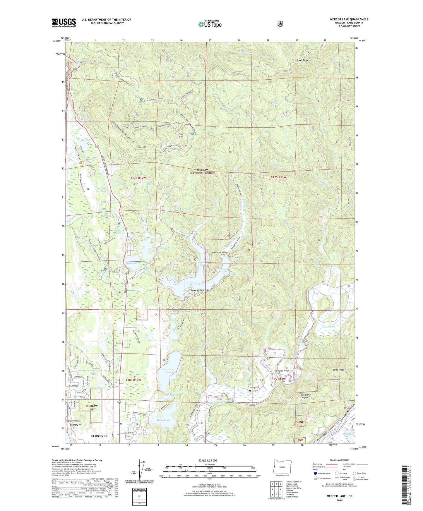
2024 topographic map quadrangle Mercer Lake in the state of Oregon. Scale: 1:24000. Based on the newly updated USGS 7.5' US Topo map series, this map is in the following counties: Lane. The map contains contour data, water features, and other items you are used to seeing on USGS maps, but also has updated roads and other features. This is the next generation of topographic maps. Printed on high-quality waterproof paper with UV fade-resistant inks.
Quads adjacent to this one:
West: Mercer Lake OE W
Northwest: Heceta Head OE W
North: Heceta Head
Northeast: Cummins Peak
East: Tiernan
Southeast: Goodwin Peak
South: Florence
Southwest: Goose Pasture
This map covers the same area as the classic USGS quad with code o44124a1.
Contains the following named places: Ackerley Creek, Ackerley Lake, Alder Dune Recreation Site, Alder Lake, Alder Lake Camp, Bailey Creek, Baker Beach Recreation Site, Bellstrom Canyon, Bender Landing Boat Ramp, Bender Landing County Park, Berry Creek, Billie Creek, Buck Lake, Cannery Hill, Cannery Point, Cape Mountain, Central Coast Ranger District-Florence Office, Clear Creek, Clear Lake, Clover Ridge, Collard Creek, Collard Lake, Condon Creek, Coon Creek, Culver Creek, Dahlin Arm, Dahlin Creek, Darlingtonia State Natural Site, Dowell Arm, Dowells Peninsula, Dry Lake Horse Camp, Duncan Inlet, Dune Lake, Dune Lake Park, Enchanted Valley, Fosback Marsh, Funke Bridge, Harbor Vista County Park, Haring Cemetery, Haring Creek, Heceta Beach Census Designated Place, Heceta Junction, Heceta Junction Lake, Heceta Water District, Herman Peak, Holman Vista Recreation Site, Horse Creek Trailhead, Houghton Landing County Park, Kilmer Spring, Lake Marr, Levage Creek, Lily Lake, Lindsley Creek, Linneus Post Office, Mercer, Mercer Creek, Mercer Lake, Mercer Lake County Park, Mercer Lake Landing Boat Ramp, Mercer Lake Resort, Mercer Lake Resort Boat Ramp, Mercer Post Office, Mitchell Creek, Morris Creek, Munsel Lake, Munsel Landing Boat Ramp, Munsel Landing County Park, Mussel Lake, Nott Lake, Noyes Creek, Oregon State Police Department - Florence Worksite, Quarry Creek, Rath Creek, Sandpines Golf Links, Siuslaw Valley Fire and Rescue Station 4 Sutton Station, Slover Creek, Sutton Lake, Sutton Launch Boat Ramp, Sutton Recreation Site, The Portage, The Slide, Three Mile Prairie, United States Coast Guard Station Siuslaw, Wendson Substation, ZIP Code: 97439