MyTopo
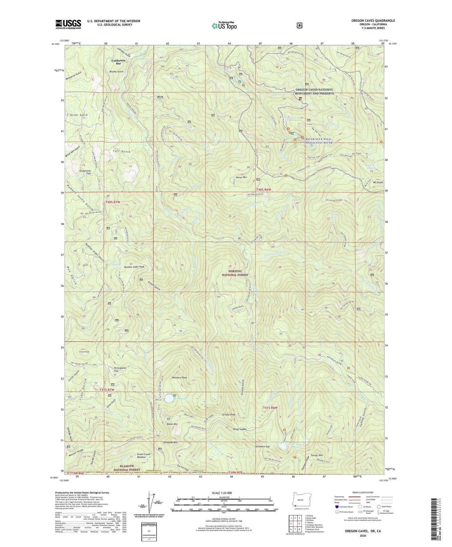
Oregon Caves Oregon US Topo Map
Couldn't load pickup availability
Also explore the Oregon Caves Forest Service Topo of this same quad for updated USFS data
2023 topographic map quadrangle Oregon Caves in the state of Oregon. Scale: 1:24000. Based on the newly updated USGS 7.5' US Topo map series, this map is in the following counties: Josephine, Siskiyou. The map contains contour data, water features, and other items you are used to seeing on USGS maps, but also has updated roads and other features. This is the next generation of topographic maps. Printed on high-quality waterproof paper with UV fade-resistant inks.
Quads adjacent to this one:
West: Takilma
Northwest: Holland
North: Kerby Peak
Northeast: Williams
East: Grayback Mountain
Southeast: Figurehead Mountain
South: Deadman Point
Southwest: Polar Bear Mountain
This map covers the same area as the classic USGS quad with code o42123a4.
Contains the following named places: Althouse Mountain, Althouse Trail, Big Tree, Bigelow Lakes, Blanket Ledge Mine, Bolan Creek, Bolan Creek Mine, Bolan Lake, Bolan Lake Recreation Site, Bolan Lake Trail, Bolan Mine, Bolan Mountain, Boundary Trail, Briggs Cabin, Brush Creek, Brush Creek Camp, Brushy Gulch, California Bar, Carr Gulch, Carson Cabin, Cave Creek Recreation Site, Cedar Camp, China Garden, Cliff Nature Trail, Cohen Creek, Cold Spring, Deadhorse Corral, Deadhorse Creek, Deep Creek, East Fork Bolan Creek, East Fork Sucker Creek Trail, East Tanner Creek, East Tanner Lake, Edmonds Mine, Elkhorn Creek, Fehley Gulch, Forest Service Bolan Lake Non - Motorized Boat Launch, French Gulch, French Peak, Fulk Cabin, Gilmore Cutoff Trail, Gold Center, Gold Dollar Creek, Green Creek Meadow, Grizzly Gulch, Grizzly Mine, Grizzly Peak, Gypsy Queen Mine, Horse Mountain, Iron Gulch, Jackass Creek, Johnson Gulch, Kester Mine, Kings Saddle, Lake Creek, Lake Mountain Trail, Layman Gulch, Left Fork Sucker Creek, Left Hand Fork Brush Creek, Limestone Creek, Limestone Trail, Lucky Strike Mine, Luethye Mine, Matz Draw, Mountain Ranch, Mule Creek, No Name Creek, Number Eight Peak, Onion Gulch, Oregon Caves National Monument and Preserve, Oregon Caves Post Office, Panther Creek, Pepper Camp, Portuguese Flat, Rainbow Mine, Rasmussen House, Serpentine Flat, Slaughterhouse, Sucker Creek Trail, Sundown Gap, Tannen Lakes Trail, Tanner Creek, Tanner Lake, Tanner Lakes, Tanner Mountain, Thirteenmile Creek, Thompson Ridge, Tiger Springs, Tip Top Mine, Weston Mountain, Weston Ridge, Whiskers Peak, Willow Spring, Yeager Creek, Yeager Mine, Yew Creek