MyTopo
Burnham Pennsylvania US Topo Map
Couldn't load pickup availability
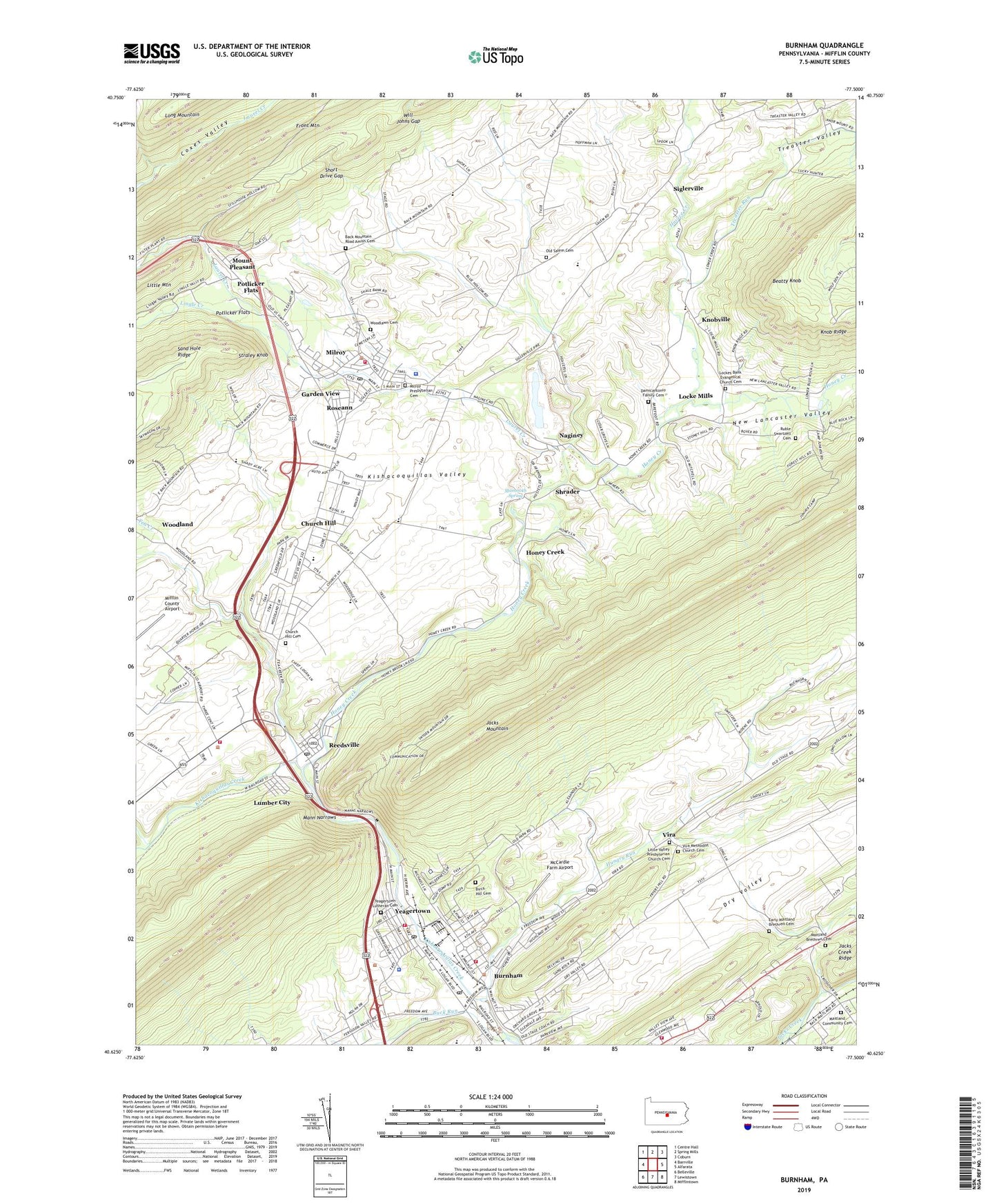
2023 topographic map quadrangle Burnham in the state of Pennsylvania. Scale: 1:24000. Based on the newly updated USGS 7.5' US Topo map series, this map is in the following counties: Mifflin. The map contains contour data, water features, and other items you are used to seeing on USGS maps, but also has updated roads and other features. This is the next generation of topographic maps. Printed on high-quality waterproof paper with UV fade-resistant inks.
Quads adjacent to this one:
West: Barrville
Northwest: Centre Hall
North: Spring Mills
Northeast: Coburn
East: Alfarata
Southeast: Mifflintown
South: Lewistown
Southwest: Belleville
This map covers the same area as the classic USGS quad with code o40077f5.
Contains the following named places: Armagh Township Elementary School, Back Mountain Road Amish Cemetery, Beatty Knob, Birch Hill Cemetery, Borough of Burnham, Brice School, Brown Township Elementary School, Buck Run, Burnham, Burnham Fire Company - Station 1, Burnham Post Office, Camp Juniata, Church Hill, Church Hill Cemetery, Church Hill Census Designated Place, Coffee Run, Coxes Valley Trail, Damicantonio Family Cemetery, Derry Elementary School, Dry Valley, Early Maitland Brethren Cemetery, East Derry Volunteer Fire Company - Station 2, Garden View, Geisinger Lewistown Hospital, Hartman Center Church, Havice Creek, Honey, Honey Creek, Honey Creek Lime Quarry, Hoopes School, Hungry Run, Kishacoquillas High School, Kishacoquillas School, Knobville, Kratzer Trail, Laurel Creek, Lingle Creek, Little Valley Presbyterian Church Cemetery, Locke Mills, Lockes Bank Evangelical Church Cemetery, Lumber City, Lumber City Census Designated Place, Maitland, Maitland Brethren Cemetery, Maitland Church, Maitland Community Cemetery, Mammoth Spring, Mann Narrows, McCardle Farm Airport, McNitt School, Mifflin County Regional Police Station, Milroy, Milroy Census Designated Place, Milroy Hose Company Station 7, Milroy Post Office, Milroy Presbyterian Cemetery, Mount Pleasant, Mount Pleasant Census Designated Place, Naginey, New Lancaster Valley, Old Salem Cemetery, Potlicker Flats, Potlicker Flats Census Designated Place, Reedsville, Reedsville Census Designated Place, Reedsville Post Office, Reedsville Volunteer Fire Company Station 6, Roseann, Ruble Swartzell Cemetery, Saint Johns Church, Saint Pauls Church, Short Drive Gap, Shrader, Siglerville, Siglerville Census Designated Place, Straley Knob, Tea Creek, Township of Derry, Treaster Run, Treaster Valley, Vira, Vira Methodist Church Cemetery, Will Johns Gap, Woodland, Woodlawn Cemetery, Yeagertown, Yeagertown Census Designated Place, Yeagertown Fire Company Station 3, Yeagertown Lutheran Cemetery, Yeagertown Post Office, ZIP Codes: 17009, 17099