MyTopo
Derry Pennsylvania US Topo Map
Couldn't load pickup availability
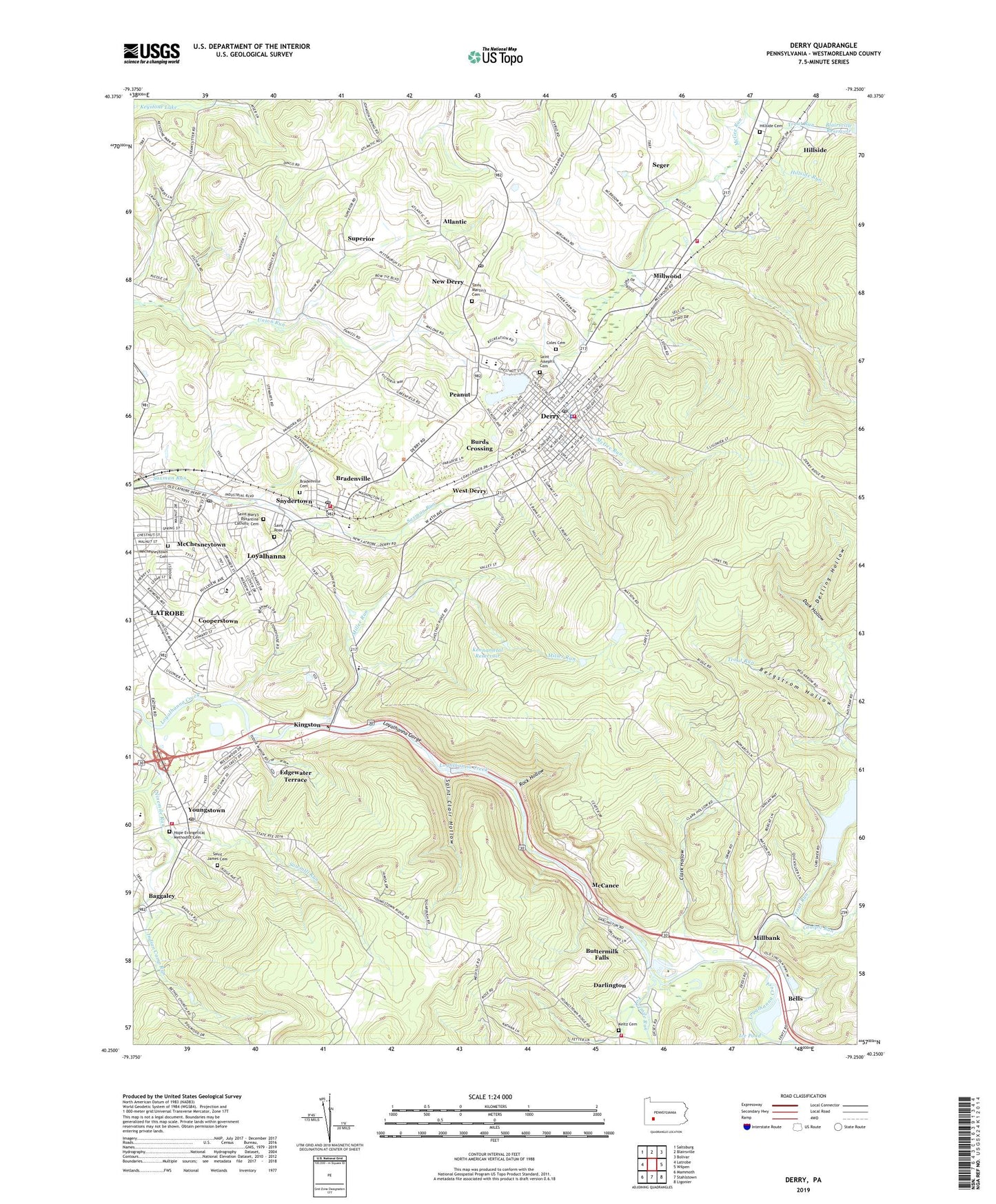
2019 topographic map quadrangle Derry in the state of Pennsylvania. Scale: 1:24000. Based on the newly updated USGS 7.5' US Topo map series, this map is in the following counties: Westmoreland. The map contains contour data, water features, and other items you are used to seeing on USGS maps, but also has updated roads and other features. This is the next generation of topographic maps. Printed on high-quality waterproof paper with UV fade-resistant inks.
Quads adjacent to this one:
West: Latrobe
Northwest: Saltsburg
North: Blairsville
Northeast: Bolivar
East: Wilpen
Southeast: Ligonier
South: Stahlstown
Southwest: Mammoth
Contains the following named places: Atlantic, Baggaley, Baggaley Dam, Bakers, Bells, Bergstrom Hollow, Blairsville-Trout Run Dam, Blue Stone Quarry, Borough of Derry, Borough of Youngstown, Bradenville, Bradenville Census Designated Place, Bradenville Elementary School, Bradenville Post Office, Burds Crossing, Buttermilk Falls, Calvary Temple, Church of Christ, Clark Hollow, Coalpit Run, Coles Cemetery, Cooperstown, Dark Hollow, Darlington, Darlington - Ligonier Township Volunteer Fire Department 3, Derry, Derry Area Junior High School, Derry Area Senior High School, Derry Borough High School, Derry Post Office, Derry Rod and Gun Club Dam, Derry Rod and Gun Club Lake, Derry Township Volunteer Fire Department Company 1 of Bradenville, Derry Volunteer Fire Company, Detling Hollow, Eastern Derry Township Volunteer Fire Department 2, Edgewater Terrace, Elks Golf Club, Ethel Springs Dam, Ethel Springs Lake, Fourmile Run, Grandview Elementary School, Hillside, Hillside Cemetery, Hillside Church, Hillside Run, Hope Evangelical Methodist Cemetery, Ice Pond, Ice Pond Dam, Idlepark, Idlewild Park, Indian Camp Run, Jack and Jill Nursery School, Keltz Cemetery, Kenametal Dam, Kennametal Reservoir, Kingston, Latrobe Country Club, Latrobe Reservoir, Latrobe Reservoir Dam, Longbridge, Loyalhanna, Loyalhanna Census Designated Place, Loyalhanna Elementary School, Loyalhanna Gorge, Loyalhanna Post Office, McCance, McChesneytown, McCune Run, Mechesneytown Cemetery, Millbank, Miller Run, Millwood, Millwood Census Designated Place, Mutual Aid Emergency Medical Service Derry Station, New Derry, New Derry Elementary School, New Derry Post Office, Ninemile Run, North Fork Coalpit Run, Osburn, Pandora, Peanut, Pershing Cemetery, Ridgeview Park Camp, Rock Hollow, Rose Cemetery, Rose Church, Sacred Heart School, Saint Clair Hollow, Saint James Cemetery, Saint Johns Church, Saint Josephs Catholic Church, Saint Joseph's Cemetery, Saint Martin's Cemetery, Saint Martins Church, Saint Mary's Byzantine Catholic Cemetery, Saint Marys Church, Saint Pauls Church, Sawmill Run, Second Ward Grade School, Seger, Snydertown, Solomon Temple, Superior, Third Ward Grade School, Timberlinks Golf Course, Trout Run, Twomile Run, West Derry, West Derry Grade School, WQTW-AM (Latrobe), Youngstown, Youngstown Post Office, Youngstown Volunteer Fire Department, ZIP Codes: 15620, 15627, 15661, 15671, 15696