MyTopo
Latrobe Pennsylvania US Topo Map
Couldn't load pickup availability
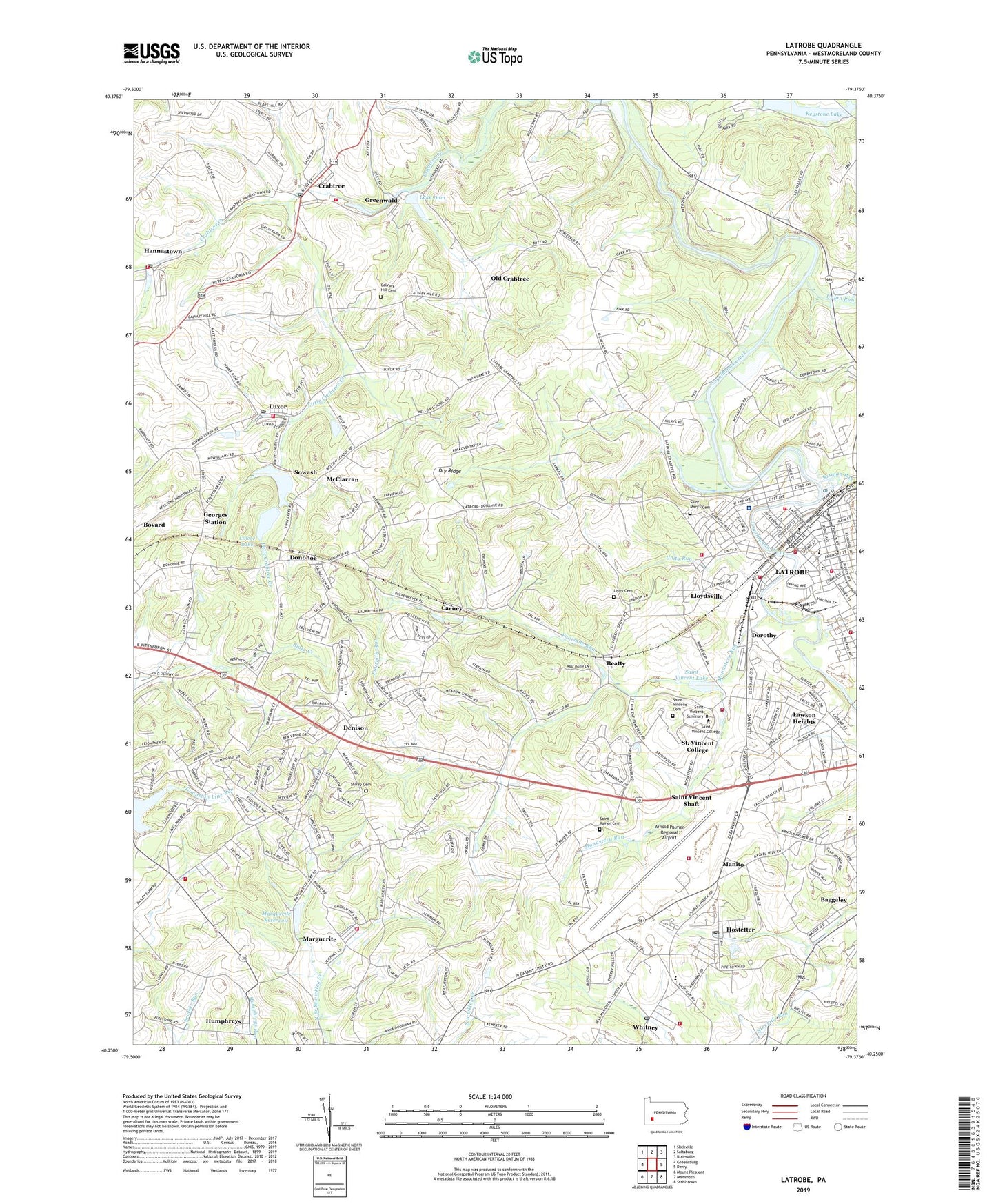
2023 topographic map quadrangle Latrobe in the state of Pennsylvania. Scale: 1:24000. Based on the newly updated USGS 7.5' US Topo map series, this map is in the following counties: Westmoreland. The map contains contour data, water features, and other items you are used to seeing on USGS maps, but also has updated roads and other features. This is the next generation of topographic maps. Printed on high-quality waterproof paper with UV fade-resistant inks.
Quads adjacent to this one:
West: Greensburg
Northwest: Slickville
North: Saltsburg
Northeast: Blairsville
East: Derry
Southeast: Stahlstown
South: Mammoth
Southwest: Mount Pleasant
This map covers the same area as the classic USGS quad with code o40079c4.
Contains the following named places: Adams Memorial Library, Arnold Palmer Regional Airport, Arnold Palmer Regional Airport Fire Department, Baggaley Elementary School, Beatty, Beatty Inn, Bell Memorial Church, Borough of Latrobe, Calvary Hill Cemetery, Carmelite Monastery, Carney, Charter Oak Church, Christ the Divine Teacher School, Crabtree, Crabtree Census Designated Place, Crabtree Post Office, Crabtree Volunteer Fire Department, Davis Run, Denison, Donohoe, Dorothy, Dry Ridge, Dry Ridge Volunteer Fire Department, Eastgate Shopping Plaza, Excela Health Latrobe Hospital, Fairmont Church, Fourmile Run, Georges Station, Greater Latrobe Senior High School, Greensburg YMCA Camp, Greenwald, Greenwalt Dam, Hannastown, Hannastown Post Office, Hannastown Volunteer Fire Department, Hostetter, Hostetter Census Designated Place, Hostetter Post Office, Keystone Lake, Keystone State Park, Lake Dom, Latrobe, Latrobe Elementary School, Latrobe Junior High School, Latrobe Post Office, Latrobe Volunteer Fire Department Free Service Fire Unit 6, Latrobe Volunteer Fire Department Freewill Hose Company 3 and 4, Latrobe Volunteer Fire Department Good Friends Hose Company 5, Latrobe Volunteer Fire Department Goodwill Hose Company 1, Latrobe Volunteer Fire Department Hook and Ladder Company 2 Headquarters, Lawson Heights, Lawson Heights Census Designated Place, Legion-Kenner Park, Little Crabtree Creek, Lloydsville, Lloydsville Volunteer Fire Department, Lower Lake, Luxor, Luxor Church, Luxor Post Office, Luxor Volunteer Fire Department, Manito, Marguerite, Marguerite Dam, Marguerite Reservoir, Marguerite Volunteer Fire Department, McClarran, Monastery Run, Mount Zion Church, Mountain View Elementary School, New Horizons School, Northern Area School, Old Crabtree, Palmers, Prince of Peace Nursery, Saint Bartholomew School, Saint Benedict School, Saint Cecilia School, Saint Joseph Hall High School, Saint Mary's Cemetery, Saint Marys Church, Saint Vincent Cemetery, Saint Vincent College, Saint Vincent College Census Designated Place, Saint Vincent College Volunteer Fire Department, Saint Vincent Lake, Saint Vincent Shaft, Saint Xavier Academy, Saint Xavier Cemetery, Saxman Run, Shirey Cemetery, Sowash, Statlers Par 3 Golf Course, Township of Unity, Twin Lakes Number One Dam, Twin Lakes Park, Union Run, Unity Cemetery, Unity Reservoir, Unity Run, Upper Donohoe Dam, Upper Lake, WCNS-AM (Latrobe), West Latrobe, Westmoreland County, Whitney, Whitney Hostetter Volunteer Fire Department, Whitney Post Office, ZIP Codes: 15624, 15638, 15650, 15662, 15693