MyTopo
Du Bois Pennsylvania US Topo Map
Couldn't load pickup availability
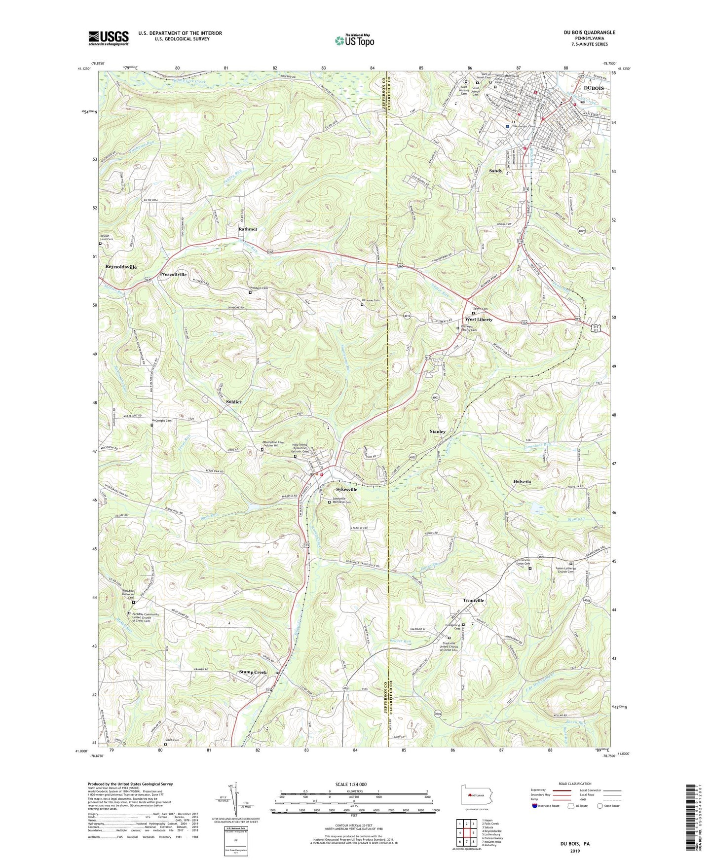
2023 topographic map quadrangle Du Bois in the state of Pennsylvania. Scale: 1:24000. Based on the newly updated USGS 7.5' US Topo map series, this map is in the following counties: Jefferson, Clearfield. The map contains contour data, water features, and other items you are used to seeing on USGS maps, but also has updated roads and other features. This is the next generation of topographic maps. Printed on high-quality waterproof paper with UV fade-resistant inks.
Quads adjacent to this one:
West: Reynoldsville
Northwest: Hazen
North: Falls Creek
Northeast: Sabula
East: Luthersburg
Southeast: Mahaffey
South: McGees Mills
Southwest: Punxsutawney
This map covers the same area as the classic USGS quad with code o41078a7.
Contains the following named places: Assumption Cemetery - Soldier Hill, Aurand School, Beaver Run, Beech Run, Bethany Church, Beulah Land Cemetery, Borough of Sykesville, Borough of Troutville, Buck Run, C and M Junction, Central Christian High School, City of DuBois, Cramer, Crossroads School, Davis Cemetery, Delarme Cemetery, Du Bois, Du Bois Area Junior High School, DuBois Emergency Medical Service Ambulance Service Station 42 - 1, DuBois Police Department, East Branch School, East Du Bois Junction, Eriton, Evangelical Cemetery, Fehley Run, First Ward School, Fourth Ward Hose Company Station 74, Fourth Ward School, Friendship Fire Company Station 71, Goodwill Hose Company Station 75, Helvetia, Helvetia Dam, Highland Street Elementary School, Holy Trinity Byzantine Catholic Cemetery, Juniata Run, Kenderman School, Liberty Post Office, Limestone Run, McConnell School, McCreight Cemetery, McCreight Run, McCreight School, Mount Zion Church, Old West Liberty Cemetery, Owens School, Panther Run, Paradise Church, Paradise Community United Church of Christ Cemetery, Paradise Lutheran Cemetery, Penn Highlands Dubois Regional Medical Center, Pentz Run, Pifer School, Poose Run, Prescottville, Prospect Cemetery, Prospect School, Rathmel, Reisinger Run, Reynoldsville Reservoir, Reynoldsville Storage Dam, Rumbarger Cemetery, Saint Catherine of Siena Cemetery, Saint Joseph Cemetery, Saint Josephs School, Saint Michael Cemetery, Saint Michaels Church, Salem Cemetery, Salem Church, Salem Lutheran Church Cemetery, Sandy, Sandy Census Designated Place, Soldier, Sons of Israel Cemetery, Stanley, Steele School, Stump Creek, Stump Creek Post Office, Sugarcamp Run, Sykes Station, Sykesville, Sykesville Ambulance Station 80, Sykesville Borough Police Department, Sykesville Elementary School, Sykesville Memorial Cemetery, Sykesville Post Office, Sykesville Volunteer Fire Company Station 8, Township of Henderson, Troutville, Troutville Union Cemetery, Troutville United Church of Christ Cemetery, Upper Bucheit School, Volunteer Hose Company Station 72, Wayne School, West Liberty, West Sandy Fire Company Station 36, Wilson School, Wilson Terrace School, ZIP Codes: 15863, 15865, 15866