MyTopo
Jersey Shore Pennsylvania US Topo Map
Couldn't load pickup availability
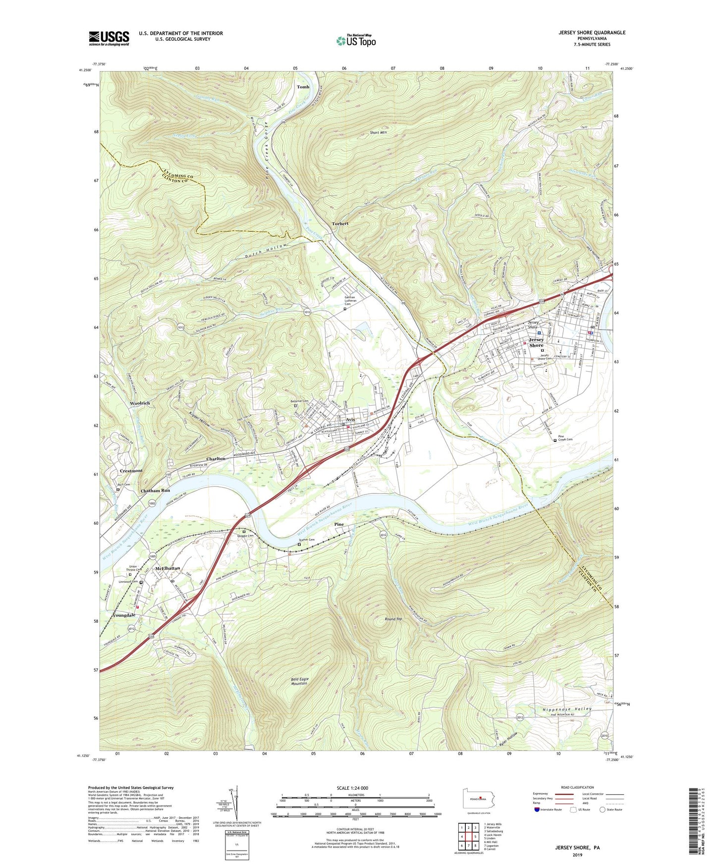
2019 topographic map quadrangle Jersey Shore in the state of Pennsylvania. Scale: 1:24000. Based on the newly updated USGS 7.5' US Topo map series, this map is in the following counties: Clinton, Lycoming. The map contains contour data, water features, and other items you are used to seeing on USGS maps, but also has updated roads and other features. This is the next generation of topographic maps. Printed on high-quality waterproof paper with UV fade-resistant inks.
Quads adjacent to this one:
West: Lock Haven
Northwest: Jersey Mills
North: Waterville
Northeast: Salladasburg
East: Linden
Southeast: Carroll
South: Loganton
Southwest: Mill Hall
Contains the following named places: Aughanbaugh Run, Avis, Avis Elementary School, Avis Post Office, Avis Volunteer Fire Company Station 8, Avis Yard, Bald Eagle Mountain, Bellevue Cemetery, Big Plum Run, Borough of Avis, Borough of Jersey Shore, Boyd Keller Reservoir Dam, Brady School, Browns, Browns Station, Center School, Charlton, Chatham Run, Citizens Hose Company of Jersey Shore Station 45, Crestmont, Dennison Hollow, Dutch Hollow, Ferguson School, Furnace Run, Gamble Run, Garman Church, Garman Lutheran Cemetery, Garman School, Gravel Hill School, Harbor Mills School, Henry Run, Independent Hose Company Station 3, Jersey Shore, Jersey Shore Area Elementary School, Jersey Shore Area Junior High School, Jersey Shore Area Senior High School, Jersey Shore Cemetery, Jersey Shore Hospital, Jersey Shore Post Office, Keller Reservoir Dam, Kissel Trail, Kryder Hollow, Kyler Hollow, Linnwood Cemetery, Little Plum Run, Love Run, McElhattan, McElhattan Census Designated Place, McElhattan Post Office, Nepley Fork, Nice Hollow, Nichols Run, Nippenose Valley, Phelps Chapel, Pine, Pine Creek, Pine Creek Cemetery, Pine Creek Gorge, Pine Creek Township Police Department, Pine Station, Quiggle Cemetery, Red School, Refuge Trail, Rich Cemetery, Round Top, Schultz Fork, Short Mountain, South Avis School, Stamm Cemetery, Sulphur Run, Tiadaghton Valley Mall, Tiadaghton Valley Regional Police Department, Tomb, Torbert, Township of Pine Creek, Township of Porter, Township of Wayne, Union - Throne Cemetery, Wayne Township Landfill, Wayne Township Volunteer Fire Company Station 10, WJSA-AM (Jersey Shore), Woodys Field, Woolrich Census Designated Place, Woolrich Park, WSQV-FM (Jersey Shore), Youngdale, ZIP Codes: 17721, 17740, 17748