MyTopo
Lock Haven Pennsylvania US Topo Map
Couldn't load pickup availability
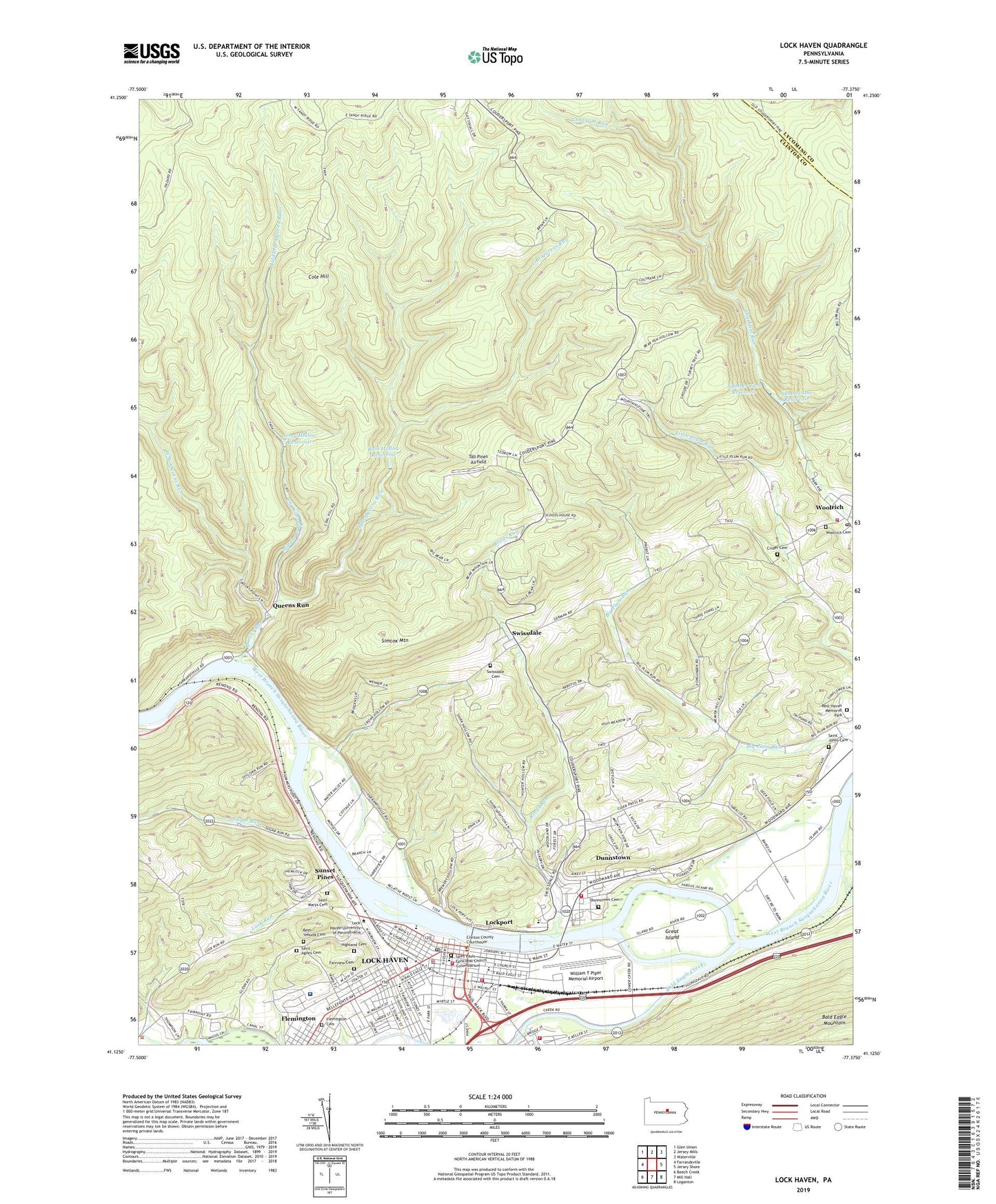
2023 topographic map quadrangle Lock Haven in the state of Pennsylvania. Scale: 1:24000. Based on the newly updated USGS 7.5' US Topo map series, this map is in the following counties: Clinton, Lycoming. The map contains contour data, water features, and other items you are used to seeing on USGS maps, but also has updated roads and other features. This is the next generation of topographic maps. Printed on high-quality waterproof paper with UV fade-resistant inks.
Quads adjacent to this one:
West: Farrandsville
Northwest: Glen Union
North: Jersey Mills
Northeast: Waterville
East: Jersey Shore
Southeast: Loganton
South: Mill Hall
Southwest: Beech Creek
This map covers the same area as the classic USGS quad with code o41077b4.
Contains the following named places: Albert N Raub Hall, Annie Halenbake Ross Library, Archibald Paul Akeley Building, Bald Eagle Creek, Beth Yehuda Cemetery, Borough of Flemington, Campus Village, Castanea Fire Company Station 3, Citizens Hose Company Station 6, City of Lock Haven, Clinton County Sheriff's Office, Cole Hill, Cornelius M Sullivan Hall, Crider Cemetery, David W Thomas Fieldhouse, Deborah M Bentley Hall, Deise School, Dickey School, Dunnstown, Dunnstown Cemetery, Dunnstown Census Designated Place, Dunnstown Volunteer Fire Company Station 5, East Branch Queens Run, Elizabeth K Zimmerle Gymnasium, Fairpoint Church, Fairview Cemetery, Flemington, Flemington Cemetery, Fredericks Family Carillion, George B Hursh and E Ross Nevel Senior Building, George B Stevenson Library, Gerald R Robinson Learning Resource Center, Great Island, Gruger Hollow Trail, Hand In Hand Hose Company Station 1, Hanna Park, Harold D Woolridge Hall, Harveys Run, Heckler School, Helen L McEntire Hall, Highland Cemetery, Hope Hose Company Station 2, Hubert H Jack Stadium, Immaculate Conception School, James H Rogers Gymnasium, Jerry Hollow Reservoir, Jesse Scott Himes Hall, John Sloan Fine Arts Center, Katherine A Glennon Health Center, Levi J Ulmer Hall, Liberty Church, Lock Haven, Lock Haven Emergency Medical Services Station 22, Lock Haven Hospital, Lock Haven Hospital Heliport, Lock Haven Police Department, Lock Haven Post Office, Lock Haven University of Pennsylvania, Lockport, Long Hollow Trail, Lusk Run, Lydia Gross Hall, McElhattan Creek, McGhee School, Middle Branch Queens Run, Mohawk Club, Morris De Turk High Hall, Number One Reservoir, Number Two Reservoir, Penn School, Pennsylvania Canal, Philip M Price Performance Center, Queens Run, Ram Hollow Reservoir, Recreation and Honors Building, Reeds Run, Rest Haven Memorial Park, Richard T Parsons Union Building, Robb School, Saint Agnes Cemetery, Saint Agnes School, Saint Johns Cemetery, Saint Marys Cemetery, Saint Pauls Episcopal Church Columbarium, Samuel Jacob Smith Hall, SCC Student Recreation Center, Simcox Mountain, Sugar Run, Sunset Pines, Swissdale, Swissdale Cemetery, Swissdale School, Tall Pines Airfield, Thomas Annex, Township of Allison, Township of Dunnstable, Township of Woodward, WBPZ-AM (Lock Haven), WBPZ-FM (Lock Haven), West Branch Queens Run, William McCollum Field, William R North Hall, William T Piper Memorial Airport, Woodward School, Woolrich, Woolrich Cemetery, Woolrich Post Office, Woolrich Volunteer Fire Company Station 12, ZIP Code: 17779