MyTopo
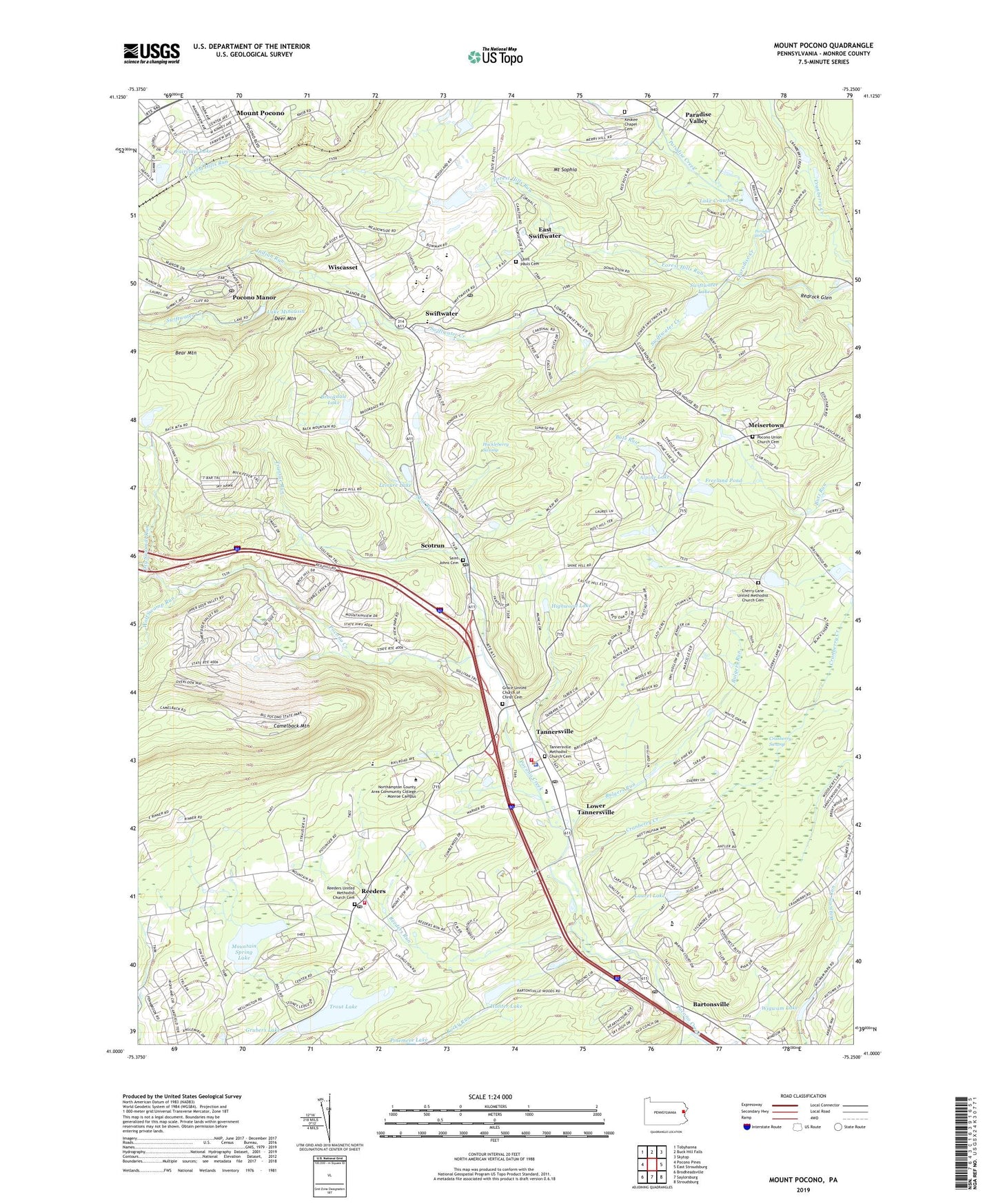
Mount Pocono Pennsylvania US Topo Map
Couldn't load pickup availability
2023 topographic map quadrangle Mount Pocono in the state of Pennsylvania. Scale: 1:24000. Based on the newly updated USGS 7.5' US Topo map series, this map is in the following counties: Monroe. The map contains contour data, water features, and other items you are used to seeing on USGS maps, but also has updated roads and other features. This is the next generation of topographic maps. Printed on high-quality waterproof paper with UV fade-resistant inks.
Quads adjacent to this one:
West: Pocono Pines
Northwest: Tobyhanna
North: Buck Hill Falls
Northeast: Skytop
East: East Stroudsburg
Southeast: Stroudsburg
South: Saylorsburg
Southwest: Brodheadsville
This map covers the same area as the classic USGS quad with code o41075a3.
Contains the following named places: Alpine Dam, Alpine Lake, Barton Glen, Bartonsville, Bartonsville Post Office, Bartonsville School, Big Pocono Overlook, Big Pocono State Park, Birchwood-Pocono Airpark, Borough of Mount Pocono, Brookdale Lake, Brookdale Lake Dam, Bulgers Run, Butz School, Camelback Mountain, Camelback Ski Area, Camelback Trail, Central Pocono Ambulance, Cherry Lane Church, Cherry Lane United Methodist Church Cemetery, Coolbaugh, Coolmoor, Cranberry Creek, Cranberry Swamp, Deer Mountain, Dry Sawmill Run, East Swiftwater, Fairview Lake, Forest Hills Run, Freeland Pond, Grace Church, Grace United Church of Christ Cemetery, Highwood Lake, Horace B Rowland State Heliport, Huckleberry Swamp, Hunter Lake, Hunter Lake Dam, Indian Run, Indian Trail, Jackson Township School, Jackson Township Volunteer Fire Company Station 27, Keokee Chapel Cemetery, Keokee Church, Kirk in the Woods Church, Lake Crawford, Lake Crawford Dam, Lake Minausin, Lake Minausin Dam, Lake Swiftwater Dam, Laurel Lake, Leisure Lake, Lindenmere Dam, Lower Tannersville, Meisertown, Meistertown Dam, Monroe County, Mount Airy Dam, Mount Airy Lodge Ski Area, Mount Pocono, Mount Pocono Overlook, Mount Sophia, Mountain School, Mountain Spring Lake, Mountain Springs Dam, Noahs Ark Dam, Our Lady of Victory Church, Paradise Falls, Paradise Valley, Parkside, Pennsylvania State Police Troop N Swiftwater Station, Pocono Elementary Center, Pocono Hotel Dam, Pocono Laurel Lake, Pocono Manor, Pocono Manor Dam, Pocono Manor Golf Course, Pocono Manor Post Office, Pocono Manor Ski Area, Pocono Mountain Junior-Senior High School, Pocono Mountain Volunteer Fire Company Station 2, Pocono Township Police Department, Pocono Township Volunteer Fire Company Station 34, Pocono Union Church, Pocono Union Church Cemetery, Ransberry Heights, Reeders, Reeders Post Office, Reeders Run, Reeders United Methodist Church Cemetery, Rocky Run, Saint Johns Cemetery, Saint Johns Church, Saint Marys Church, Saint Pauls Cemetery, Saint Pauls Church, Sand Spring Run, Scot Run, Scotrun, Scotrun Post Office, Ski Haven Lake Estates, Stricklands Wissasset Golf Course, Swiftwater, Swiftwater Creek, Swiftwater Lake, Swiftwater Post Office, Tannersville, Tannersville Learning Center, Tannersville Methodist Church Cemetery, Tannersville Post Office, Tannersville Station, Township of Jackson, Township of Paradise, Township of Pocono, Transue Run, Trinity Church, Trout Lake, Whitestone Dam, Wigwam Lake, Wigwam Lake Dam, Wigwam Lake Estates, Wilson Dam, Wiscasset, Wolf Swamp Run, ZIP Codes: 18321, 18332, 18344, 18349, 18352, 18355, 18370, 18372