MyTopo
Tamaqua Pennsylvania US Topo Map
Couldn't load pickup availability
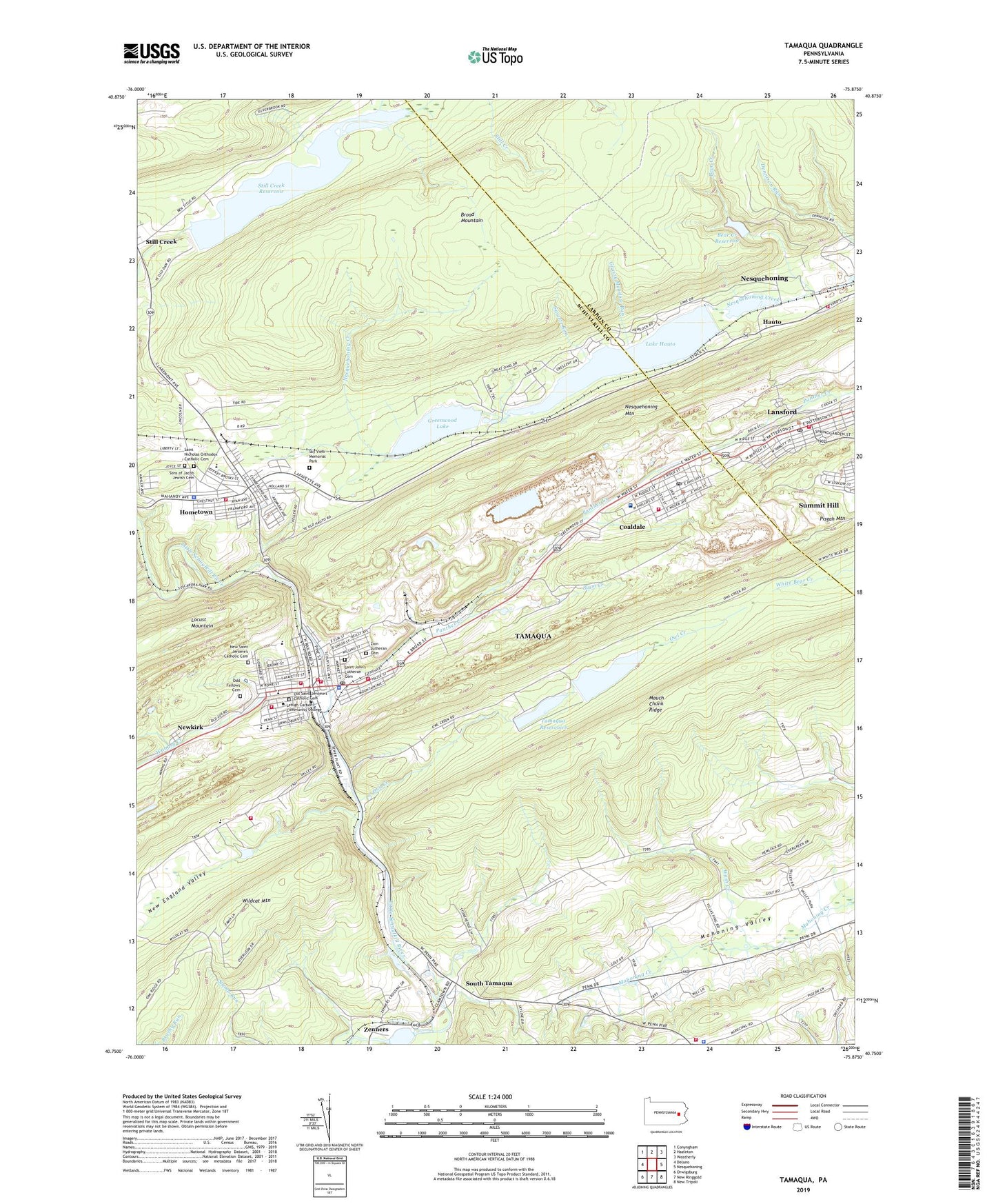
2019 topographic map quadrangle Tamaqua in the state of Pennsylvania. Scale: 1:24000. Based on the newly updated USGS 7.5' US Topo map series, this map is in the following counties: Schuylkill, Carbon. The map contains contour data, water features, and other items you are used to seeing on USGS maps, but also has updated roads and other features. This is the next generation of topographic maps. Printed on high-quality waterproof paper with UV fade-resistant inks.
Quads adjacent to this one:
West: Delano
Northwest: Conyngham
North: Hazleton
Northeast: Weatherly
East: Nesquehoning
Southeast: New Tripoli
South: New Ringgold
Southwest: Orwigsburg
Contains the following named places: American Fire Company 1 District 15, American Hose Company District 65 Station 1, Arlington Yards, Bear Creek, Bear Creek Dam, Bear Creek Reservoir, Borough of Coaldale, Borough of Lansford, Borough of Tamaqua, Camp Wildcat, Citizens Fire Company District 65 Station 2, Coaldale, Coaldale Borough Police Department, Coaldale Post Office, Coaldale Volunteer Fire Company District 40 Station 1, East End Fire Company District 65 Station 3, Grassy Meadow Run, Greenwood Dam, Greenwood Lake, Hauto, Hauto Station, Hauto Volunteer Fire Company District 13, Hometown, Hometown Census Designated Place, Hometown Mall, Hometown Volunteer Fire Company District 25 Station 1, Lake Hauto, Lake Hauto Dam, Lansford, Lansford Post Office, Lansford Volunteer Ambulance, Locust Creek, Longacre Siding Station, Lower Owl Creek Dam, Mayor's Office, Nesquehoning Mountain, New England, New England Fire Company District 32 Station 1, New England School, New England Valley, New Saint Jerome's Catholic Cemetery, Newkirk, Odd Fellows Cemetery, Old Saint Jerome's Catholic Cemetery, Owl Creek, Owl Creek School, Panther Creek, Pisgah Mountain, Rabbit Run, Rabbit Run Dam, Robin Run, Rush Elementary School, Rush Township Police Department, Saint John's Lutheran Cemetery, Saint Lukes Miners Memorial Hospital, Saint Nicholas Orthodox Catholic Cemetery, Sky View Memorial Park, Skyview Memorial Park, Slum Creek, Sons of Jacob Jewish Cemetery, South Tamaqua, South Ward Fire Company District 65 Station 4, State Game Lands Number 227, State Game Lands Number 257, Still Creek, Still Creek Dam, Still Creek Reservoir, Swartz Run, Tamaqua, Tamaqua Area High School, Tamaqua Area Junior High School, Tamaqua Community Ambulance Association, Tamaqua Elementary School, Tamaqua Police Department, Tamaqua Post Office, Tamaqua Rescue Squad, Tamaqua Reservoirs, Township of Rush, Upper Owl Creek Dam, Upper Owl Creek Reservoir, Valley Park Estates, Village Square Mall, Wabash Creek, Wash Creek, Wash Creek School, West Penn Fire Company District 37 Station 1, West Penn Township Elementary School, West Penn Township Police Department, Wildcat Mountain, Zenners, Zion Lutheran Cemetery, ZIP Codes: 18218, 18232, 18252