MyTopo
Chester South Carolina US Topo Map
Couldn't load pickup availability
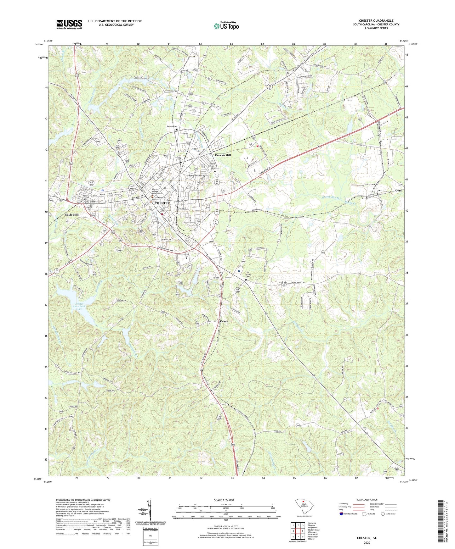
2024 topographic map quadrangle Chester in the state of South Carolina. Scale: 1:24000. Based on the newly updated USGS 7.5' US Topo map series, this map is in the following counties: Chester. The map contains contour data, water features, and other items you are used to seeing on USGS maps, but also has updated roads and other features. This is the next generation of topographic maps. Printed on high-quality waterproof paper with UV fade-resistant inks.
Quads adjacent to this one:
West: Baton Rouge
Northwest: Armenia
North: Lowrys
Northeast: Edgemoor
East: Richburg
Southeast: Stover
South: Blackstock
Southwest: Carlisle SE
This map covers the same area as the classic USGS quad with code o34081f2.
Contains the following named places: Airlee, Atkinson Pond D-0228 Dam, Benson Cemetery, Bethel Church, Bethel United Methodist Church, Bolins Pond D-0229 Dam, Brockman School, Brooklyn, Brooklyn African Methodist Episcopal Church, Brooklyn School, Carmel Presbyterian Church, Cedar Grove, Cedar Rock Church, Cedar Rock School, Center for Retarded Children, Chapel Branch, Chester, Chester Associate Reformed Presbyterian Church, Chester Christian School, Chester City Hall, Chester County, Chester County Courthouse, Chester County Fairgrounds, Chester County Library, Chester County Rescue Squad, Chester Division, Chester Fire Department Station 1, Chester Fire Department Station 10, Chester High School, Chester Historic District, Chester Mall Shopping Center, Chester Plaza Shopping Center, Chester Police Department, Chester Post Office, Chester Reservoir, Chester State Park, Chester State Park Lake, Chesterville Female Seminary, Church of God, City of Chester, College Street School, County Farm Industrial Park, Dora Jones-Gayle Elementary School, Douglas School, Eureka Baptist Church, Eureka Church, Eureka Community House, Eureka Mill, Eureka Mill Census Designated Place, Eureka Mills, Eureka School, Evans, Evergreen Cemetery, Faith Church, Finley School, First Baptist Church, Foote Street Elementary School, Forest Hills, Friendship Church, Gayle Mill, Gayle Mill Census Designated Place, Gayle School, Grassy Run Branch, Harshaw Pond Dam D-3666, High Point School, Hilltop Acres, Jones School, Lakewood, Lincolnville Church, Logan Farm, Metropolitan African Methodist Episcopal Church, Mount Calvary Baptist Church, Mount Hebron Cemetery, Mount Olive Baptist Church, MUSC Health Chester Medical Center, Old Purity Cemetery, Old Wilson Church, Oliver Church, Orrs Baptist Church, Parkway Baptist Church, Peden Oaks, Peoples Plaza Shopping Center, Pineview Lakes, Pleasant Grove Church, Pleasant View Church, Pryor Hospital, Purity Presbyterian Church, Quail Hollow, Rocky Creek WCD Dam Number Eight D-0214, Rocky Creek WCD Dam Number Nine D-0215, Rocky Creek WCD Dam Number Six D-0213, Rolling Hills Estates, Ruckers Crossroads, Saint James Church, Saint Josephs Catholic Church, Saint Marks Episcopal Church, Saluda Square Shopping Center, Sanctified Church, Sandy River Church, Second Wilson Baptist Church, South Carolina Highway Patrol Troop 4 Post C, South Carolina Noname 12001 D-0206 Dam, South Carolina Noname 12006 D-0210 Dam, South Carolina Noname 12011 D-0211 Dam, South Carolina Noname 12012 D-0223 Dam, South Carolina Noname 12013 D-0224 Dam, South Carolina Noname 12014 D-0225 Dam, South Carolina Noname 12021 D-0222 Dam, South Carolina Noname 12022 D-0227 Dam, South Carolina Noname 12023 D-0220 Dam, South Carolina Noname 12025 D-0218 Dam, South Chester Fire Department Station 2, Southside School, Springwood Lakes, Stringfellow, Threemile Branch, Trinity Church, Twomile Branch, Union Church, WDZK-FM (Chester), Westside Baptist Church, WGCD-AM (Chester), Williamsville Church, Witherow School, Woodward Baptist Church, Wylie Mills, Wylie Park, York Road School, York Terrace, ZIP Code: 29706