MyTopo
McColl South Carolina US Topo Map
Couldn't load pickup availability
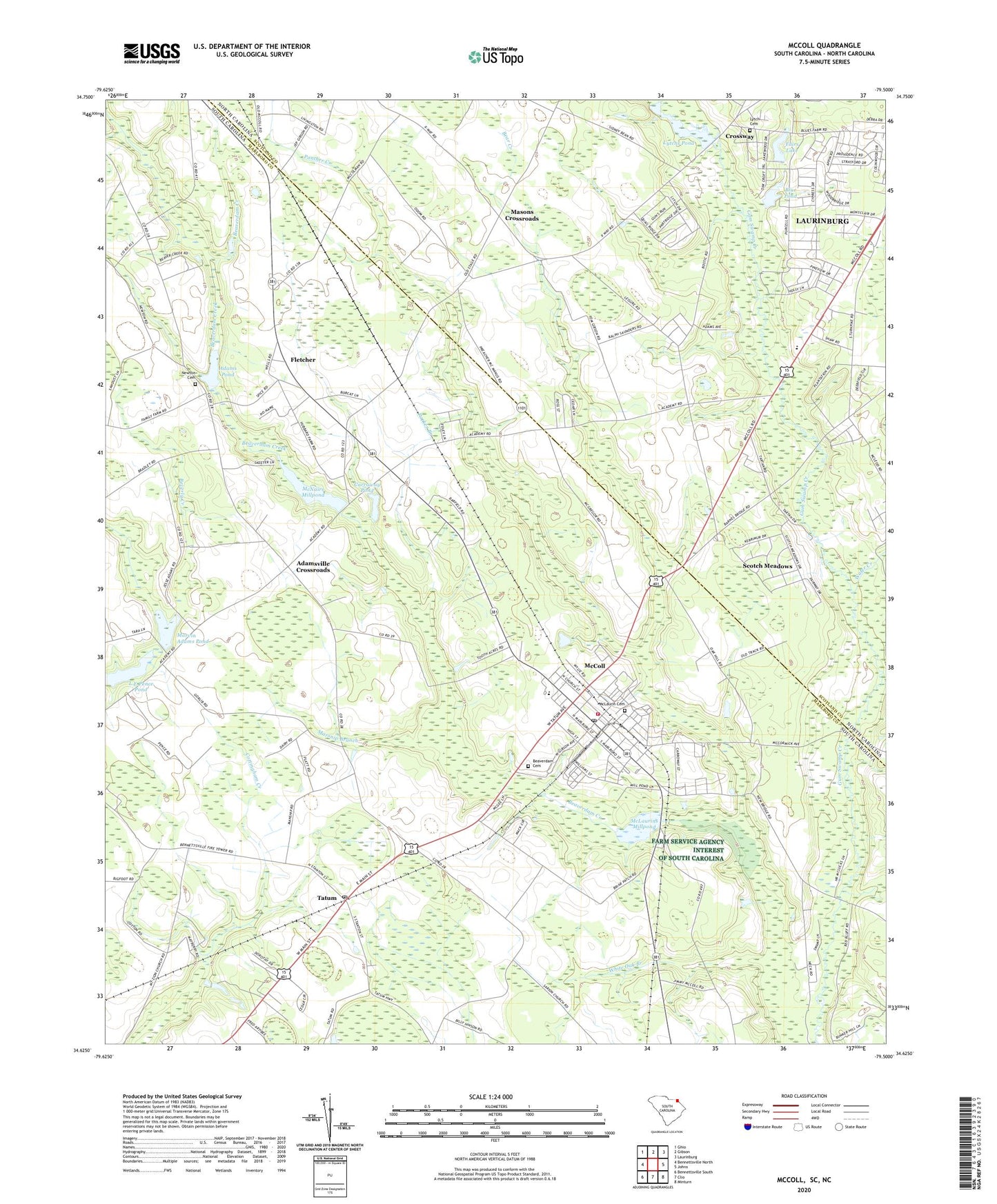
2024 topographic map quadrangle McColl in the states of South Carolina, North Carolina. Scale: 1:24000. Based on the newly updated USGS 7.5' US Topo map series, this map is in the following counties: Marlboro, Scotland. The map contains contour data, water features, and other items you are used to seeing on USGS maps, but also has updated roads and other features. This is the next generation of topographic maps. Printed on high-quality waterproof paper with UV fade-resistant inks.
Quads adjacent to this one:
West: Bennettsville North
Northwest: Ghio
North: Gibson
Northeast: Laurinburg
East: Johns
Southeast: Minturn
South: Clio
Southwest: Bennettsville South
This map covers the same area as the classic USGS quad with code o34079f5.
Contains the following named places: Adams Pond, Adams Pond Dam D-3439, Adamsville Crossroads, Adamsville School, Bear Creek, Beaverdam Cemetery, Bennettsville Lookout Tower, Blue Acres, Blue Pond, Blue Pond Dam, Carraway Pond, Carraway Pond Dam D-3447, Community Chapel, Crossway, Delta Pond Dam D-3462, Dry Branch School, Eastside Baptist Church, Emmanuel Church, Fairplain Church, Fairs Lake, Fairs Lake Dam, First Baptist Church, Fletcher, Fletcher Grove Church, Fletcher Grove School, Fletcher Memorial School, Fletchers Chapel, Friendship Church, Highland Park, Hopewell Church, Hopewell School, Idlewood, Kenmoor, L E Pence Pond, Laurin Lake, Lytch Cemetery, Lytchs Pond, Main Street Methodist Church, Marsnip Branch, Marvin Adams Pond, Masons Crossroads, Matthews Chapel, Mc Nairs Millpond, McCall Church, McCall Pond Dam D-3448, McCall School, McColl, McColl Church of God, McColl Division, McColl Elementary School, Mccoll Fire Department, McColl Middle School, McColl Post Office, McColl-Fletcher Memorial High School, McLaurin Cemetery, McLaurins Mill, McLaurins Millpond, McNairs Mill, Montclair, Mount Zion Church, Newton Cemetery, Panther Creek, Parker Branch, Pine Forest, Pine Grove Church, Piney Plain Church, Reedy Creek Church, Saint Paul School, Saint Pauls Church, Scotch Meadows Census Designated Place, Scotch Meadows Country Club, South Carolina Noname 35011 D-3446 Dam, South Carolina Noname 35041 D-2949 Dam, Stewartsville Church, Sunset Church, Tatum, Town of McColl, Town of Tatum, Trinity Church, Water Creek, Whispering Pines, White Oak Branch, Woodrun, X Way Mill Pond, X Way Mill Pond Dam, ZIP Codes: 29570, 29594