MyTopo
Rabon Crossroads South Carolina US Topo Map
Couldn't load pickup availability
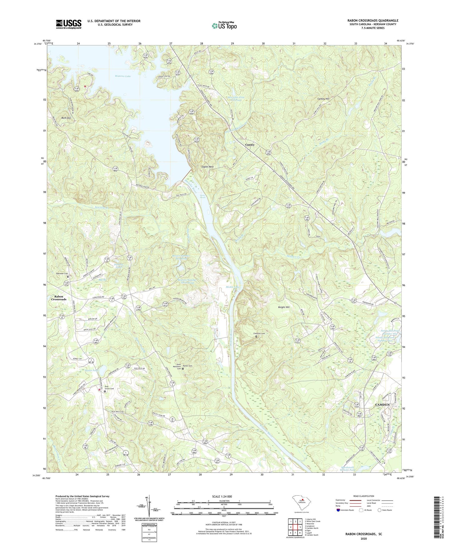
2024 topographic map quadrangle Rabon Crossroads in the state of South Carolina. Scale: 1:24000. Based on the newly updated USGS 7.5' US Topo map series, this map is in the following counties: Kershaw. The map contains contour data, water features, and other items you are used to seeing on USGS maps, but also has updated roads and other features. This is the next generation of topographic maps. Printed on high-quality waterproof paper with UV fade-resistant inks.
Quads adjacent to this one:
West: Longtown
Northwest: Liberty Hill
North: White Oak Creek
Northeast: Westville
East: Camden North
Southeast: Camden South
South: Lugoff
Southwest: Elgin
This map covers the same area as the classic USGS quad with code o34080c6.
Contains the following named places: A P Bowen Number Two Pond Dam D-2533, A P Bowens Number One Pond Dam D-2534, A P Bowens Number Three Pond Dam D-2535, Adamsons Mill, Barker School, Bee Branch, Bee Tree, Bowen Number Two Pond, Bowens Number One Pond, Bowens Number Three Pond, Branham Heights, Buck Hill, Camden Conference Center, Cantey, Cantey Hill, Cantey Hill School, Chesnuts Ferry, Chestnut Cemetery, Chestnuts Mill, Eagles Nest, Ebenezer Cemetery, Ebenezer Church, Flint Hill Church, Gains Church, Gents Crossing, Good Hope Church, Good Hope School, Grannies Quarter Creek, Graves Ford, Grooms Park, Hensons Store, Horse Head Branch, Joseph Kershaw School, Kershaw County Fire Department Pine Grove, Kershaw County Fire Department Pine Grove Substation, Kirkover Hills, Knight Hill, Knight Hill School, Knights Hill, Knights Hill Plantation, Knights Mill, Lake Wateree, Loves Shoals, Macdonald Willetts Pond, McGuirts Flint Hill Pond, McGuirts Flint Hill Pond Dam D-2500, McGuirts House Pond Number One, McGuirts House Pond Number One Dam D-2524, McGuirts House Pond Number Two, McGuirts House Pond Number Two Dam D-2525, Mickle Lake, Mickle School, Oliver Pond, Oliver Pond Dam D-2529, Parker Cemetery, Parker Church, Parker School, Parkers Pond, Parkers Pond Dam D-1326, Pilgrim Church, Pine Grove Cemetery, Pine Grove Church, Pine Grove School, Rabon Crossroads, Rocky Branch, Roundton Church, Saint Matthews Cemetery, Saint Matthews Methodist Episcopal Church, Saint Pauls Church, Sanders Creek, Sanders Creek Church, Sandy Hill Pond Number Two, Sawneys Creek, Scott Park, Shiloh Church, South Carolina Noname 28016 D-2522 Dam, South Carolina Noname 28025 D-1145 Dam, South Carolina Noname 28046 Dam, Spring Lake, Springdale Plantation, Springdale Race COurse, Springvale Baptist Church, Sunny Hill Plantation, Sunny Hill Pond Dam Number Two D-2526, Sunnyhill, Susie Barfield Pond Dam D-2531, Susies Pond, Vaughans Mill, Vaughns Mill Pond, Wateree Canal, Wateree Dam, Wateree Power Plant, Wateree School, Windsor Heights, Woodward Park