MyTopo
Birchwood Tennessee US Topo Map
Couldn't load pickup availability
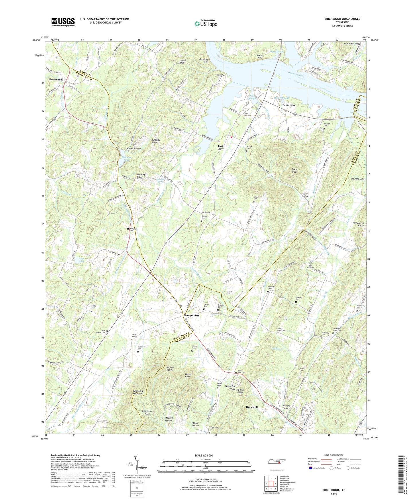
2019 topographic map quadrangle Birchwood in the state of Tennessee. Scale: 1:24000. Based on the newly updated USGS 7.5' US Topo map series, this map is in the following counties: Hamilton, Meigs, Bradley. The map contains contour data, water features, and other items you are used to seeing on USGS maps, but also has updated roads and other features. This is the next generation of topographic maps. Printed on high-quality waterproof paper with UV fade-resistant inks.
Quads adjacent to this one:
West: Grasshopper Creek
Northwest: Graysville
North: Big Spring
Northeast: Goodfield
East: Charleston
Southeast: East Cleveland
South: South Cleveland
Southwest: Snow Hill
Contains the following named places: Agency Creek, Agency Creek Recreation Area, Allford Branch, Anderson Cemetery, Anderson Spring Branch, Barger Cemetery, Barger Knob, Bedwell Branch, Bettis Cemetery, Birchwood, Birchwood Baptist Church, Birchwood Post Office, Birchwood School, Brittsville, Brittsville Baptist Church, Burdette Church, Burdette Ridge, Burnette Church, Camelot, Clint Hill Cemetery, Clint Hill School, Cofer Cemetery, Commissioner District 1, Corinth Cemetery, Davis Cemetery, East View, East View Baptist Church, East View Cemetery, East View School, Eastview Baptist Church, Eastview Elementary School, Etola, Fisher Hollow, Flag Pond, Fransico Cemetery, Fuller Slough, Funderburg Cemetery, Gamble Cemetery, Georgetown, Georgetown Baptist Church, Georgetown Post Office, Goodman Bluff, Graham Cemetery, Gum Springs Baptist Church, Gunstocker Creek, Hinkle Cemetery, Hooper Slough, Horner Hollow, Hunter Cemetery, Jewell Bluff, Johnson Cemetery, Judd Slough, Kincannon Ferry, Kincannons Ford, Lewis Branch, Lewis Valley, Lick Creek, Matthews Cemetery, McClanahan Cemetery, McClanahan Ferry, McCulley Ridge, McCulley Spring, McGaha Hollow, McKinney Cemetery, Meadowview Elementary School, Meigs County Emergency Services Fire Rescue Station 1, Misty Ridge, Mount Zion Cemetery, Mount Zion Methodist Church, Mount Zion Ridge, Mungers Pond, Mungers Pond Dam, Murphy Cemetery, Neeley Cemetery, New Union Church, NIRA Rod and Gun Club, No Pone Valley, Pleasant Hill School, Russell Ferry, Saint Elmo Cemetery, Saint Elmo Church, Saint Elmo School, Smith Cemetery, Smith Chapel Cemetery, Standfield Cemetery, Standfield Church, Stokes Hill, Sugar Creek, Swafford-David Cemetery, Taliaferro Gap, Texas Knobs, West Fork Gunstocker Creek, White Hollow, Wolf Pond, ZIP Codes: 37308, 37336