MyTopo
Graysville Tennessee US Topo Map
Couldn't load pickup availability
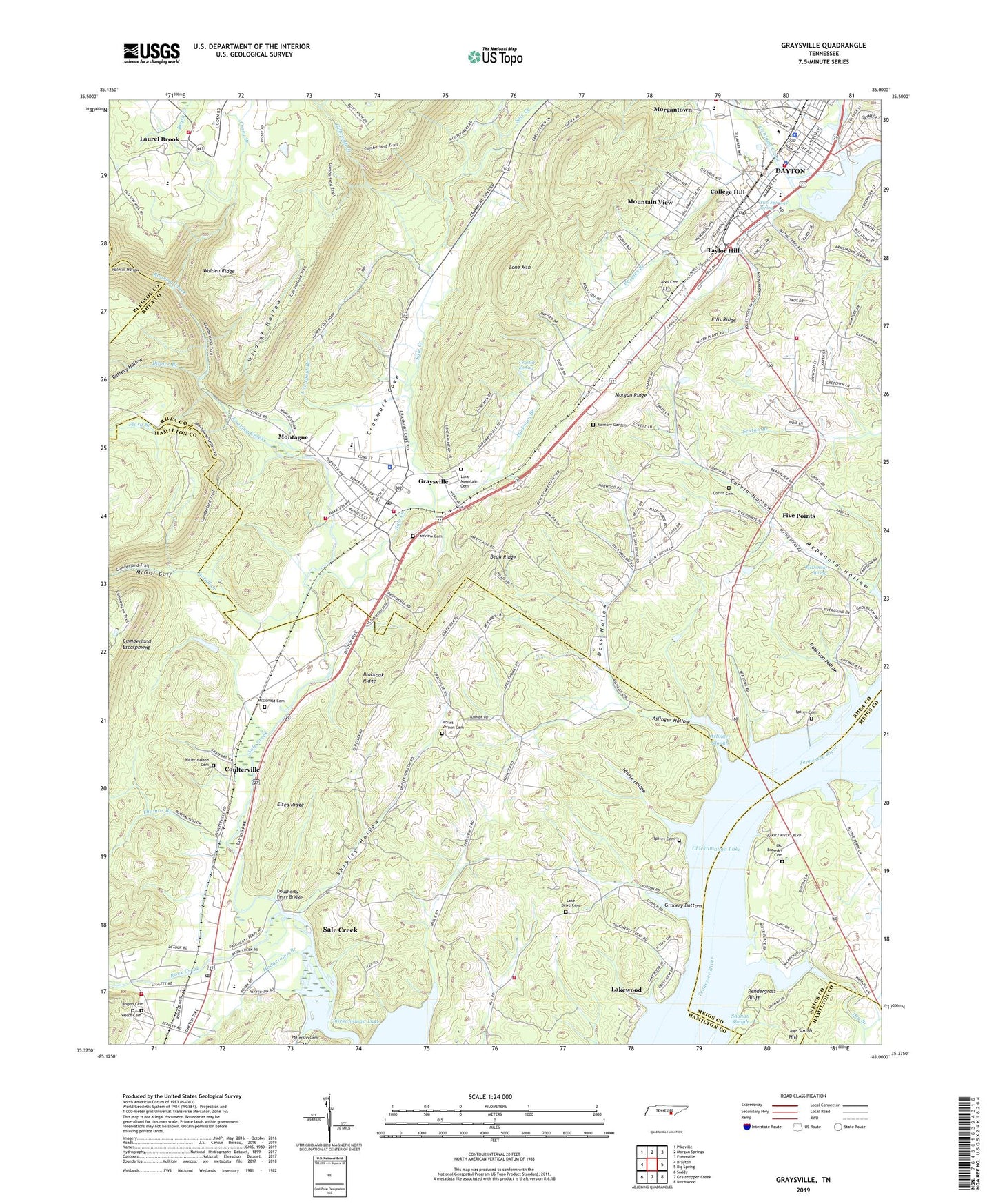
2022 topographic map quadrangle Graysville in the state of Tennessee. Scale: 1:24000. Based on the newly updated USGS 7.5' US Topo map series, this map is in the following counties: Rhea, Hamilton, Meigs, Bledsoe. The map contains contour data, water features, and other items you are used to seeing on USGS maps, but also has updated roads and other features. This is the next generation of topographic maps. Printed on high-quality waterproof paper with UV fade-resistant inks.
Quads adjacent to this one:
West: Brayton
Northwest: Pikeville
North: Morgan Springs
Northeast: Evensville
East: Big Spring
Southeast: Birchwood
South: Grasshopper Creek
Southwest: Soddy
This map covers the same area as the classic USGS quad with code o35085d1.
Contains the following named places: Abel Cemetery, Aslinger Hollow, Aslinger Slough, Battery Hollow, Bean Ridge, Bear Branch Access Area, Blackoak Ridge, Blythe Ferry, Broyles Branch, Brush Creek, Bryan Hill, Calvary Baptist Church, Church of Christ, City of Dayton, College Hill, Commissioner District 6, Commissioner District 8, Corvin Cemetery, Corvin Hollow, Coulterville, Cranmore Cove, Crystal Spring, Curry Branch, Dayton, Dayton City Hall, Dayton Fire Department Station 1, Dayton Masonic College, Dayton Municipal Park, Dayton Plaza Shopping Center, Dayton Police Department, Dayton Post Office, Dayton Public Library, Dinner Branch, Doss Hollow, Dougherty Ferry Bridge, Doughty Ferry, Dry Branch, Ellis Ridge, Elsea Ridge, Fairview Cemetery, First Baptist Church, First Baptist Church of Sale Creek, First Church of Christ, First United Methodist Church, Five Points, Five Points School, Flora Branch, Garrison Church, Gilbreath Creek, Grace Bible Church, Graysville, Graysville Church of God, Graysville Elementary School, Graysville Police Department, Graysville Post Office, Graysville United Methodist Church, Graysville Volunteer Fire Department, Grocery Bottom, Harbor Lights Boat Dock, Hickman Branch, Hinkle Hollow, Hiwassee Ferry, Hiwassee River, Hodgetown Branch, Lake Drive, Lake Drive Baptist Church, Lake Drive Cemetery, Lakewood, Laurel Brook, Laurelbrook Volunteer Fire Department Station 770, Litchfield Branch, Lone Mountain, Lone Mountain Cemetery, Maley Hollow, Mc Donald Hollow, McDonald Cemetery, McDonald Spring, McDonalds Mill, McGill Creek, McGill Gulf, Memory Garden, Miller-Nelson Cemetery, Montague, Morgan Ridge, Mount Marriah African Methodist Episcopal Church, Mount Olive Church, Mount Olive United Methodist Church, Mount Vernon Cemetery, Mount Vernon Church, Mount Zion Baptist Church, Mountain View, Mountain View Church, Mountain View United Methodist Church, New Providence Church, New Providence School, Old Browder Cemetery, Patterson Cemetery, Pendegrass Park, Pendergrass Bluff, Point Park, Polecat Hollow, Rhea Central Elementary School, Rhea Central High School, Rhea County Courthouse, Rhea County Fire Department Station 760 Garrison Fire District, Rhea County Fire Department Station 780 Graysville Fire District, Rhea County Jail, Rhea County Sheriff's Department, Richland Park Shopping Center, Roaring Creek, Robinson Hollow, Rock Creek, Rogers Cemetery, Sale Creek, Sale Creek Census Designated Place, Sale Creek Post Office, Sale Creek School, Sale Creek Volunteer Fire and Rescue Station 2, Sale Creek Volunteer Fire and Rescue Station 4, Seventh Day Adventist Church, Shahan Slough, Shipley Hollow, South Dayton, Spivey Cemetery, Spivey Church, Spivey School, Swinging Bridge Park, Taylor Hill, Thomas Branch, Town of Graysville, Trinity United Methodist Church, Two Spjrings spring, Wayside Church, WDNT-AM (Dayton), Welch Cemetery, Wildcat Hollow, WNFM-FM (Dayton), ZIP Code: 37373