MyTopo
Big Spring Tennessee US Topo Map
Couldn't load pickup availability
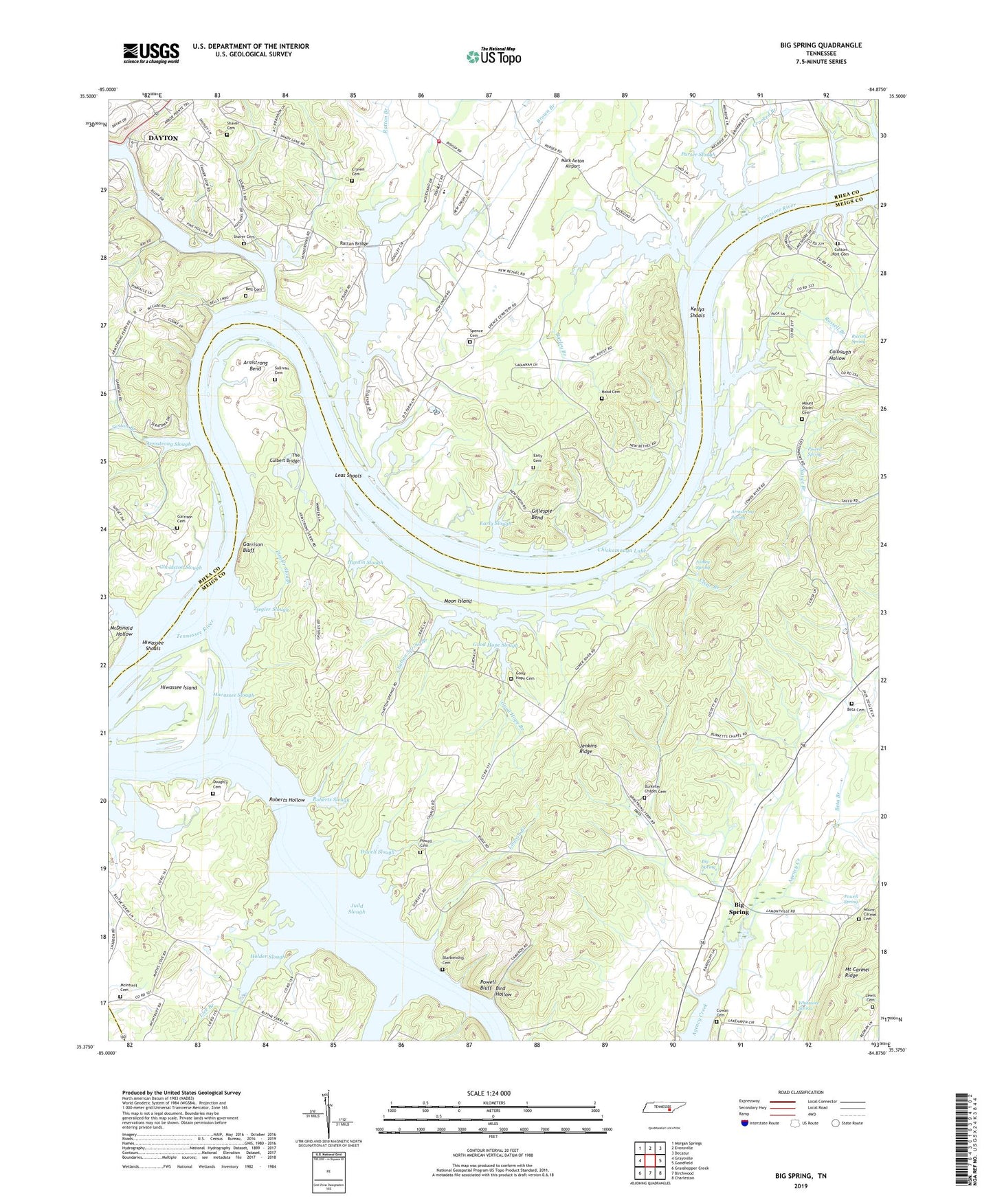
2022 topographic map quadrangle Big Spring in the state of Tennessee. Scale: 1:24000. Based on the newly updated USGS 7.5' US Topo map series, this map is in the following counties: Meigs, Rhea, Hamilton. The map contains contour data, water features, and other items you are used to seeing on USGS maps, but also has updated roads and other features. This is the next generation of topographic maps. Printed on high-quality waterproof paper with UV fade-resistant inks.
Quads adjacent to this one:
West: Graysville
Northwest: Morgan Springs
North: Evensville
Northeast: Decatur
East: Goodfield
Southeast: Charleston
South: Birchwood
Southwest: Grasshopper Creek
This map covers the same area as the classic USGS quad with code o35084d8.
Contains the following named places: Armstrong Bend, Armstrong Ferry, Armstrong Ferry Recreation Area, Armstrong Slough, Armstrong Spring, Ashley Spring, Barley Branch, Bell Cemetery, Bells Landing, Beta Branch, Beta Cemetery, Beta Church, Big Spring, Big Spring-East View Division, Big Springs Church of Christ, Bird Hollow, Blankenship Cemetery, Blue Water Campground, Blythe Ferry Goose Management Area, Brown Branch, Bryan College, Bunker Hill Ferry, Burkett Chapel, Burketts Chapel Cemetery, Burketts Chapel School, Cayuga Town, Center Point School, Chatten Spring School, Chatton Spring Branch, Chickamauga Lake, Chub Arnold Landing, Clear Branch, Colbaugh Hollow, Commissioner District 2, Commissioner District 7, Coppinger Creek, Cotton Port, Cotton Port Cemetery, Cotton Port Church, Cotton Port Ferry, Cotton Port Marina and Campground, Cotton Port Road Church, Cotton Port Wildlife Management Area, Cottonport School, Cowan Cemetery, Craven Cemetery, Crawford Branch, Crooked Branch, Dallas Lake, Doughty Cemetery, Early Cemetery, Early Slough, Edgewater, Frazier School, Garrison Bluff, Garrison Cemetery, Garrison Ferry, Garrison School, Gholdston Slough, Gillespie Bend, Good Hope Branch, Good Hope Cemetery, Good Hope Church, Good Hope Slough, Gravel Hill School, Hardin Slough, Hiwassee Garrison, Hiwassee Island, Hiwassee Shoals, Hiwassee Slough, Hiwassee Wildlife Refuge, Holder Slough, Hood Cemetery, Jenkins Ridge, Kellys Shoals, Kingsfield Landing, Lagoon Branch, Lake Richland Boat Dock, Leas Shoals, Lewis Cemetery, Lick Branch, Lower Moon Landing, Mark Anton Airport, McDonald Hollow, McInturff Cemetery, Moon Island, Moon Landing, Mount Carmel Cemetery, Mount Carmel Church, Mount Carmel Ridge, Mount Carmel School, Mount Olivet Cemetery, Mount Olivet Church, Mud Creek, Nance Branch, New Bethel Church, New Union Church, Pineland, Pineland Ferry, Piney Acres, Powell Bluff, Powell Cemetery, Powell Slough, Powell Spring, Purser Slough, Rattan Branch, Rattan Bridge, Rhea County Fire Department Station 750 Frazier Fire District, Richland Creek, Roberts Hollow, Roberts Slough, Russell Branch, Russell Spring, Salem Church, Sexton Branch, Shaver Cemetery, Spence Cemetery, Sullivan Cemetery, Tennessee Wildlife Refuge, The Culbert Bridge, Tucker Ferry, Whitmore Spring, Ziegler Island, Ziegler Slough