MyTopo
Calderwood Tennessee US Topo Map
Couldn't load pickup availability
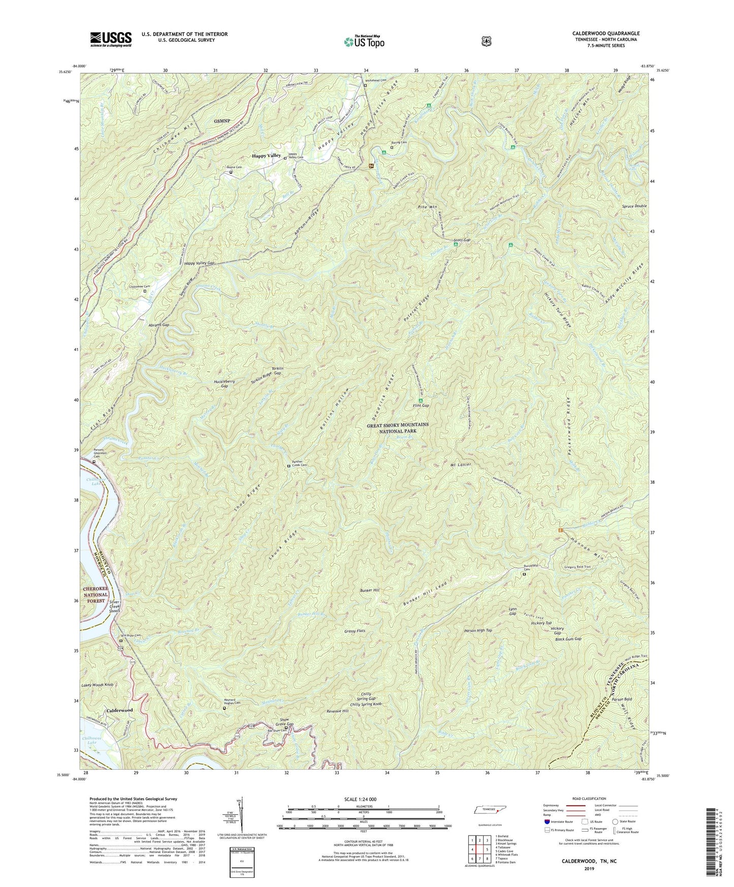
2019 topographic map quadrangle Calderwood in the states of Tennessee, North Carolina. Scale: 1:24000. Based on the newly updated USGS 7.5' US Topo map series, this map is in the following counties: Blount, Swain, Monroe. The map contains contour data, water features, and other items you are used to seeing on USGS maps, but also has updated roads and other features. This is the next generation of topographic maps. Printed on high-quality waterproof paper with UV fade-resistant inks.
Quads adjacent to this one:
West: Tallassee
Northwest: Binfield
North: Blockhouse
Northeast: Kinzel Springs
East: Cades Cove
Southeast: Fontana Dam
South: Tapoco
Southwest: Whiteoak Flats
Contains the following named places: Abrams Creek, Abrams Creek Campground, Abrams Creek Shoals, Abrams Falls, Abrams Gap, Abrams Ridge, Andy McCully Branch, Andy McCully Ridge, Bas Shaw Cemetery, Bear Den Branch, Bell Branch, Bell Cove Branch, Bible Creek, Black Gum Branch, Black Gum Gap, Blacksmith Branch, Boarhog Branch, Boone Cemetery, Boring Cemetery, Bruin Branch, Buck Shank Branch, Bunker Hill, Bunker Hill Branch, Bunker Hill Lead, Burchfield Cemetery, Calderwood, Carsons Iron Works, Cattail Branch, Chilhowee Cemetery, Chilhowee Primitive Baptist Church, Chilly Spring Gap, Chilly Spring Knob, Chilogatee Branch, Cooper Road Campsite, Deadrick Ridge, Flat Ridge, Flint Gap, Flint Gap Campsite, Garland School, Gourley Ford, Grassy Flats, Hannah Branch, Hannah Mountain, Hannah Mountain Trail, Happy Valley, Happy Valley Gap, Happy Valley Missionary Baptist Church, Happy Valley Missionary Baptist Church Cemetery, Happy Valley Ridge, Happy Valley School, Hickory Gap, Hickory Top, Hickory Turn Branch, Hickory Turn Ridge, Huckleberry Branch, Huckleberry Gap, Kingfisher Creek, Kreider Branch, Little Bottom Campsite, Little Bottoms Trail, Lynn Gap, Lynn Gap Branch, Maynard Creek, Maynard Hughes Cemetery, McCully Branch, Mill Branch, Mill Creek, Mink Branch, Mitchell Branch, Mount Lanier, Murray Branch, Oak Flats Branch, Panther Creek, Panther Creek Cemetery, Pardon Branch, Parson Bald, Parson High Top, Parson Lead, Parsons - Ghormley Cemetery, Peckerwood Branch, Peckerwood Ridge, Pine Mountain, Polecat Branch, Polecat Ridge, Rabbit Creek, Rabbit Creek Campsite, Revenue Hill, Rollins Hollow, Sawmill Ridge, Scott Gap, Scott Gap Branch, Shaw Grave Gap, Shootly Branch, Shop Creek, Shop Ridge, Silver Creek Shoals, Skunk Ridge, Slaty Branch, Spruce Double Branch, Stickbait Branch, Sweet Gum Branch, Tabcat Creek, Tarkiln Branch, Tarkiln Gap, Tarkiln Ridge, W H Pryor Cemetery, Weasel Branch, Wedge Ridge, Whitehead Cemetery, Wilham, Wilson Branch, Wolf Ridge, ZIP Code: 37878